

Friday, May 31, 2013
Ensay Burial Ground
Before we leave Ensay I want to show you this beautiful hand-lettered sign mounted on the rusting gate of the burial ground. It made me realize I was on sacred ground, and I did walk over the site with care. I took this photo in 1998. Is the sign still there?
Thursday, May 30, 2013
The Buried Chapel of Ensay
This photo is of the sand buried chapel at Manish on the north end of Ensay, which is visited in chapter 13 of book 2. The chapel was excavated and extensively studied by Dr A.E.W. Miles, and the findings written up in the British Archaeology Review, Series 212, 1989 (ISBN 086054673X). If you are interested there are some copies out there for sale, only $185 or so. A bit pricey for me, so I managed to find a copy of it in a library. There is a fascinating photo in the report that shows the altar of the chapel when it was excavated in 1971. I did not want to post it without permission, which would be hard to get as Dr Miles passed away in 2008.

Wednesday, May 29, 2013
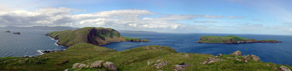
Ruiasg Buidhe Cross
Standing next to Tobar Oran, St Oran's Well, in the grounds of Colonsay House is the 7th or 8th century Riasg Buidhe cross. It has two other names; the Oran Stone, and Dealbh na Leisg (the image of laziness). The stone was taken from a burial ground in Riasg Buidhe village, two kilometres SE of Colonsay House, and is one of the most interesting cross stones in the islands. The praying monk depicted on it is part man, part fish. At the following links you will find more info on this remarkable stone: Canmore and Proceedings of Scottish Antiquaries. Page 121 of the second link has a wonderful illustration of the stone.


Tuesday, May 28, 2013
Lunga Village
I first visited the islands of Scotland in 1989. Mull was the first, followed by Iona on the following day. My wife and I had brought my parents along, and my father became very sick. The entire time we were on Iona he was sick in bed at the Argyll Hotel. He loves cats, and so Fingal, the hotel cat. was a great comfort to him while he recuperated. My wife and I did manage to see some of the sites, and were able to get out on one of the Turas Mara trips to Staffa and Lunga. This photo of my wife Shawna shows her finding some shade in Lunga village, last occupied in 1857.

Monday, May 27, 2013
Erraid Observatory
This is the observatory on Erraid. It was not made for observing stars, but was built on this spot, a hundred feet above the
sea, as a sheltered post to monitor the Dubh Artach lighthouse on its rocky perch,
fifteen miles to the south-west. Floating in the bay below is the Halmar Borge, and in the distance is the hill of Dun-I on Iona.
 |
| The Observatory - Iona in the distance |
 |
| The view from the windows of the observatory |
Sunday, May 26, 2013
Castlebay
Castlebay is one of my favorite places: the friendly people; the flowing Gaelic; the opportunities for exploration on Barra itself; and visits to the historic offshore islands. I have taken many trips to those islands with Donald McLeod on his boat Boy James, and one of the highlights of each trip was the view of Castlebay on the way back after having spent a day on Mingulay, Pabbay, Sandray, or Barra Head.

Saturday, May 25, 2013
The Blathaisbhal Stones
This linear setting of standing stones lies on the northwest shoulder of Blathaisbhal of North Uist. The stones are aligned with another standing stone some three kilometres away in Bealach Maari, the low pass between the hill of Maari (to the left) and the distinctive hump of Crogary Mor (to the right). There is said to be a cave of gold atop Crogary Mor. When I climbed it I found no gold, but the view over North Uist and the Sound of Harris was something to treasure.

Thursday, May 23, 2013
Aird Bheag
It seems so long ago, just a few months before 9/11, that I hiked in to spend the night in Aird Bheag, the true back of beyond of the Hebrides. (See chapter 21 of book 2.) I am looking forward to returning there next month with the Islands Book Trust. They have arranged a visit to remote Aird Bheag in conjunction with the launch of An Trusadh - Memories of Crofting in the Ardveg, by John MacDonald.
 |
| Aird Bheag viewed from the slopes of Mullach na Aird Bheag |
 |
| Inside one of the ruins |
 |
| The Walled Garden |
 |
| The track from the settlement down to Loch Hamanavay |
 |
| A campsite to remember |
 |
| A soggy, but happy camper |
 |
| The way in, and the way out: The Burma Road to Hamanavay climbs to the fog shrouded pass of Bealach Raonasgail |
Ord House - Skye
This is Ord House on the west side of the Sleat Peninsula of Skye. My wife and I stayed here in the spring of 1992 when it was being run as a guest house. It was made famous in Alexander Smith's A Summer in Skye, and Alasdair Alpin MacGregor also mentions staying here in one of his books. Last I heard it was no longer offering B&B and had been put up for sale. Next to the house is the site of Teampull Choan (St Congan's Church). I searched the area for a while, but could not find any trace of it. Congan was the brother of St Kentigerna of Inchcailloch in Loch Lomond, and another place dedicated to him is Kilchoan, where the RO/RO ferry to Tobermory runs.


 |
| Inside Ord House - my wife Shawna and an Ord kitty |
Wednesday, May 22, 2013
Skellig Michael
A few posts ago I mentioned some island failures; one of which was an aborted attempt to climb the south peak of Skellig Michael off the coast of Kerry. (Okay, it's not a Scottish island). The ascent is described in what is one of the most incredible books on an island ever written: The Forgotten Hermitage of Skellig Michael. The link will take you to an on-line version of the book, including all its wonderful illustrations.
It is a straightforward walk up a steep path to get to the monastic ruins on the north peak, and the first photo shows my wife clinging to its summit rock with the dramatic pinnacle of the south peak off in the distance.
It is a straightforward walk up a steep path to get to the monastic ruins on the north peak, and the first photo shows my wife clinging to its summit rock with the dramatic pinnacle of the south peak off in the distance.

Photo 2 of the south peak shows the site of the hermitage oratory and 'The Spit' at the top where a cross incised stone pillar once stood. Pilgrims would make their way up to the spit and then crawl out onto it to kiss the cross. Sadly the cross-stone fell into the sea in the 1970s. I set out to climb the peak, but I soon came to a narrow ledge that wound around a blind corner (see figure 17 in the above link). There was nothing below the ledge but a 400 foot drop to the rocks and sea. I could not do it, and turned back.

Although I had not made it to the south peak, seeing the cluster of beehive cells and oratories of the monastery on the north peak was a memorable experience.

Tuesday, May 21, 2013
Belnahua of the Slate Isles
This is a view of Belnahua of the Slate Isles, visited in chapter 10 of book 1. The name means either the mouth of the cave, or the place of the tomb. The island was a slate quarry for centuries, and the pool you see in the photo is one of its flooded quarry pits. If you ever get the chance to set foot on Belnahua be careful. The terrain is crisscrossed by small tunnels, and one wrong step could be hazardous to your health.

Monday, May 20, 2013
Island Failures
Everyone wants to write about their successes, not their failures. I have had more island-going failures than I care to count. The biggest was a failed ascent of the south peak of Skellig Michael. Someday I will write about that - having to traverse an 8 inch ledge with a shear 400 feet drop to one side scared the hell out of me and I turned back. It seems the older I get, the less head for heights I have (or maybe the more sense I have).
Another failure was trying to set foot on Hyskeir, a small islet with a Stevenson lighthouse built in 1904. I have been on two trips now where we attempted to land, but on both times the swell was too much to get safety ashore. I hope to try again this coming August.
Another failure was trying to set foot on Hyskeir, a small islet with a Stevenson lighthouse built in 1904. I have been on two trips now where we attempted to land, but on both times the swell was too much to get safety ashore. I hope to try again this coming August.
 |
| Hyskeir |
Sunday, May 19, 2013
Corryvreakan Whirlpool
I have been through Corry a few times now. The whirlpool was very active the first time, but was disappointingly quiet on all the other crossings. This photo, from that first time in 2003, shows one of the many mini-whirlpools that make up the maelstrom. There is no better expert on the whirlpool than Mike Murray, who skippered the boat I took this photo from. You can find out more about Mike and the whirlpool here.

Saturday, May 18, 2013
The Water Horse of Loch Lomond 2
We will leave Inchtavannach with Rosa. Instead of swimming, this time she's being chauffeured across on a barge. At this link you can see some photos of one of Rosa's fellow islanders, Shosoni, swimming the waters.
An interesting side note (to me anyway) - my father grew up in Shoshone, Idaho. There they pronounce it "sho-shone", but my father told me the native Americans pronounced it "Sho-shoni". So Shosoni, the island-horse, living so far from Idaho, has an authentic name.

Friday, May 17, 2013
Inchtavannach Campsite 2
A few years ago I spent a night atop the Hill of the Bell on Inchtavannach. It was here that St Kessog rang his bell, and carved into the rock of the summit is graffiti dating back two hundred years.
Sadly the islands in Loch Lomond are often overrun by thoughtless visitors, including many who let their dogs run loose to harass sheep and kill wallabies. But fortunately on the night of my stay I had the summit all to myself. If you zoom in on the photo you might spot a wee bottle of Lagavulin. I was flying home the next day, and since they won't let you take an open bottle through security I had to drink it all up. I slept like a baby.

Thursday, May 16, 2013
The Hill of the Bell
This is the view looking south from the top of Tom na Clag, the hill of the Bell, on the island of Inchtavannach. It was up here that St Kessog rang his bell to call the faithful to service. Sadly the bell went missing a few centuries ago. I try to climb the hill once a year, but that's always been in the spring or summer. How I wish I could have been here on December 31, 2009, when a bell was brought up here to ring in the new year.

Wednesday, May 15, 2013
Inchtavannach Campsite 1
I have been fortunate to have camped on Inchtavannach a few times. This photo shows the first place I camped on a quiet spot above a small bay at the north end of the island. When I woke in the morning I hiked to the top of the island to cook breakfast. The summit is known as the Hill of the Bell. Tomorrow we'll head up there for a look.

Tuesday, May 14, 2013
The Water Horse of Loch Lomond
Meet Rosa, who earns a living pulling a carriage for weddings in and around the village of Luss. She lives on Inchtavannach, an island in Loch Lomond, and here you can see her swimming home. We'll be visiting Rosa's island over the next few days.

Monday, May 13, 2013
The Shiants
We now head across the Minch to the Shiants (the holy or sacred isles). Both these photos were taken from atop Eilean Tige looking north to Garbh Eilean. The first photo also shows the garden isle of the Shiants, Eilean Mhuire, off to the right. If you want to learn more about these islands there is no better book than Adam Nicolson's Sea Room. And in Hereward Proops The Sound of Shiant you'll encounter Na Fir Gorm, the Blue Men of the Minch, who live here in a subterranean cavern only reachable underwater. It's a great read.
 |

Sunday, May 12, 2013
eBooks
I resisted trying out eBooks for years. There is something special about the feel and smell of a printed book, especially old ones. But when my books came out in eBook format last month I broke down and bought a Kindle. I really like it, and the ability to tap on the photos and maps to make them full screen is a great feature. The books were feeling a little lonely on the device, so for $4 I also bought the complete works of Sir Walter Scott and Robert Louis Stevenson. Talk about value for money!
 |
| Expanded map view on Kindle |
 |
| Expanded photo view on Kindle |
Saturday, May 11, 2013
Dry Harbour - South Rona
This is Escape Cottage above the shore of Acairseid Thioram, South Rona's Dry Harbour. The tide was out when I took this photo, so you can see dried-out harbour to the left of the cottage. My wife and I spent a week here in 2004 and 2007. We want to go back.

Friday, May 10, 2013
Bren Guns on South Rona
The first photo is a view of the hilltop south of Rona Light. A flag is flown from the little building whenever they are doing submarine or torpedo testing in the deep waters off Rona. The flag is to alert boaters that they need to steer clear of the area.
When I first climbed the hill I found hundreds of shell casings scattered over every nook and cranny not covered by heather. Commandos had landed in the bay below, and then scrambled up to this high ground. Once here they unleashed a Bren gun, a 22 pound machine gun capable of being fired by one man (see third photo). It was part of a training exercise, one that also included a six mile sortie across Rona, an island with some of the most difficult terrain in the Hebrides. I did not bring a Bren Gun, just a can of beer, which I enjoyed along with the view out over the Minch (second photo).

 |
 |
| Bren Gun |
Thursday, May 9, 2013
Loch Braig - South Rona
This is a view of Loch Braig at the north end of South Rona. To take the photo I left the path to Braig village just south of the loch, and then headed uphill through giant clusters of dense heather. This challenging terrain has been used for commando training, and I later came across some of the litter they'd left behind on a nearby hilltop, which we'll visit tomorrow.
 |
| Loch Braig - South Rona |
Wednesday, May 8, 2013
Moy Castle 6
We will say goodbye to Moy with this photo of the nearby Episcopal Church of St Kilda, built by the MacLaine's around 1876. The dedication to St. Kilda is unusual, for there was probably no such saint. But the site has been holy ground for centuries, as a sandstone cross built into its south wall may date to the 12th century.
 | |
|
Tuesday, May 7, 2013
Moy Castle 5
Leaving the pit prison we ascend a narrow circular stairway to the top of the tower. From the crumbling parapets you can see down into the overgrown interior of the castle. And looking out over the wall an old galley slip can be seen slicing into the shore. Moy castle played a prominent role in the movie I Know Where I'm Going, and it was up here that the fictional stone engraved with a 'curse' was mounted on the wall. If you ever have a chance to get inside Moy, be sure you see the movie first. For although there was never such a stone, it will be a memorable experience for you to stand on the parapets here while recalling the scene when the Laird of Kiloran realizes the true meaning of the words on the stone.

 |
| Galley Slip? |
Monday, May 6, 2013
Moy Castle 4
After exploring the ground floor I was led up a narrow stairway to a small side chamber. On its floor lay a plywood panel, set there to prevent anyone from inadvertently falling into the pit. That had actually happened to one of the owner’s dogs (but they’d managed to rescue it). The panel was lifted up to expose a narrow hole in the floor. Looking down into the dark pit I could make out a flat surface of pitch-black water. The water level was high so I could not see the rock at the bottom where a prisoner could stand to keep their head above the water.
 |
| Entrance to the prison |
 |
| Looking into the pit (the bright spot is the reflection of the camera flash on the water) |
Sunday, May 5, 2013
Moy Castle 3
This ground floor room in Moy castle is what may have been the chapel. Just around the corner a small flight of stairs leads up to the Hall. You can find photos of the hall, and of several other rooms in the castle in this link. Sadly, none of my photos of the hall turned out. This was back in the days of film cameras, when you had no idea what your photos were like until a few weeks after you got home. What a disappointment it was to open an envelope of developed photos only to discover a bunch were underexposed. Of course the challenge these day of having camera cards that can hold hundreds of photos is to not spend all your time taking pictures.
Tomorrow we'll climb a narrow stairway to peer down into the pit prison.

Saturday, May 4, 2013
Moy Castle 2
It was in 1991 that I first visited Moy Castle. I had not done any checking, and assumed I could get inside to see its infamous pit prison. But when I got there I was greeted with this padlocked door. So close, yet so far. As recounted in chapter 30 of book 2, I returned in 2003 after making arrangements to see inside. Tomorrow we'll get this door unlocked and go in.

Friday, May 3, 2013
Moy Castle 1
The last time I saw Moy Castle, on the shore of Loch Buie, was in the summer of 2010, when an Icelandic volcano stranded me in Scotland for a few weeks. But where better to be stranded!
It was then that I took this not so picturesque photo of the castle, for as you can see it was under renovation. The second photo was taken seven years earlier during a visit in 2003, when I was fortunate to be given a tour of the inside of the castle, which we'll see over the next few days.
PS: I just learned that Kindle and eBook versions of the books are now available. See links on the right side of the blog.
PS: I just learned that Kindle and eBook versions of the books are now available. See links on the right side of the blog.
 |
| Moy Castle - 2010 |
 |
| Moy Castle - 2003 |
Thursday, May 2, 2013
Afoot on Kerrera 12
We will say goodbye to Kerrera (for now, anyway) from the top of the island. This view is looking north to Oban. So where shall we head tomorrow? Any suggestions? Mull is not too far away. Perhaps we should visit Moy Castle, famous for its prominent role in the movie I Know Where I'm Going, and for its waterlogged pit prison.

Wednesday, May 1, 2013
Afoot on Kerrera 11
One of the last things you'd expect to find on a Scottish island are parrots. As I was returning to the ferry from Gylen a couple of years ago I came across the Island Parrot Sanctuary. Many of the birds here were rescued after years of living in cages or closets. When I asked why one of the parrots was missing a foot, they told me the awful way that the parrot hunters captured birds. As bait they'd super glue a parrot by the foot to a tree branch. Its cries would draw other parrots in to see what was wrong, and as they did they were captured.


Subscribe to:
Posts (Atom)