On May 21st the ship Hjalmar Bjorge left Oban. Aboard were Joey, Patricia, Janet, John, Francis, Elaine, Clare, Nigel, and myself. There were three crew; skipper Mark, his wife Anna, and Lynda the cook. It was my first cruise acting as a guide, and I was a uncertain as to how the next 10 days would go. But I was certain that the selection of islands we hoped to visit would offer some amazing experiences.
After a calm night at anchor in Tobermory Bay we set out the next morning to attempt to land on Pabbay, a deserted island south of Barra. Under partly sunny skies we approached Pabbay from the east, the white sand beach of Traigh Bhan glowing in occasional sunshine. In short order we were ashore, and made our way to the ruins of what had been Pabbay's only village.
 |
| Ashore on Pabbay |
I'd only been to Pabbay once before, back in 2007 on the boat Boy James, skippered by Donald Macleod (see book 2, chapter 9). Aside from wanting to return to a beautiful and historic island, I wanted to see how they'd permanently mounted its amazing Pictish Symbol stone.
We all made our way across the sands to the village, which was last occupied in 1911. Its cluster of black houses have been drastically altered into sheep pens, and standing above them is the shell of Taigh nam Bochdan, the house of spectres. I will not recount the long, strange history of this haunted house, but you can find it in chapter 9 of book 2.
 |
| Taigh nam Bochdan |
Next to the village is Pabbay's massive burial mound. There used to be a chapel on it, but there's no sign of it these days. At the base of the mound stands the symbol stone. When I saw it in 2007 it was lying prone, as if it had been tossed aside. But a few years ago they securely mounted it upright. I was happy to see they've done that, and that its carvings are no longer subject to direct rainfall and the feet of uncaring visitors.
 |
| Mark & Anna on the burial mound - symbol stone at base |
Even though they did good work by mounting the stone upright, it is something that should have been done a very long time ago; for the mysterious Pictish symbols, the crescent/v-rod, and the lily, are so badly worn that there is not much left of them. The next photo shows the side of the stone with the symbols, but you can not see them. All that's visible is the Christian cross at the top, a later addition to the stone. For a better (and much older) photo see page 87 of book 2 (or this
CANMORE page).
 |
| The worn symbol stone |
After we explored the village I led a group over a grassy ridge to Dunan Ruadh, a broch ruin on the east coast of the island. The broch was in direct line-of-sight with Dun Sandray, a broch on the island of Sandray, three miles to the northeast. The brochs were located such that a fire beacon could easily relay news from island to island that unfriendly visitors were in the area.
 |
| Dunan Ruadh - Sandray in the distance |
 |
| Dunan Ruadh |
The climb over to Dunan Ruadh was hard going through the thick, tall grass that covers most of the island, which makes Pabbay one of the harder islands to explore on foot. After a few hours ashore we gathered back at the beach to board the inflatable and return to Hjalmar Bjorge. Pabbay was an excellent first island of the trip, and next up was nearby Sandray.
 |
| Pabbay anchorage |
But when we went to take a look at the Sandray beach landing, it was too swelly, and so we made our way to anchor for the night in the east bay of Vatersay. There were only a few clouds in the sky, and as there were several hours of daylight left we went ashore for a walk.
 |
| East Bay - Vatersay |
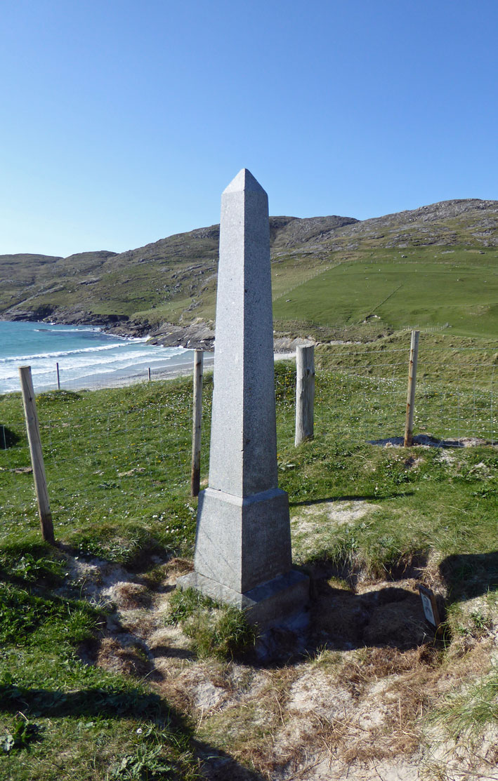
No visit to Vatersay is complete without seeing the Annie Jane memorial, and so we paid our respects to the site where over 300 people are buried who drowned when the immigrant ship Anne Jane ran aground in 1853. You can find a list of the victims
here.
 |
| Annie Jane Monument |
After over 150 years of blowing sand the words carved at the base of the monument are hard to read. Fortunately I copied them down when I first visited Vatersay in 1998:
ON 28th SEPR 1853 THE SHIP ANNIE JANE WITH EMIGRANTS
FROM LIVERPOOL TO QUEBEC WAS TOTALLY WRECKED IN THIS BAY AND
THREEFOURTHS OF THE CREW AND PASSENGERS NUMBERING
ABOUT 350 MEN WOMEN AND CHILDREN WERE DROWNED AND
THEIR BODIES INTERRED HERE
AND THE SEA GAVE UP THE DEAD WHICH WERE IN IT REV: XX 13
I've visited the monument many times over the years, but this time I noticed something different. In the sand next to the obelisk was a board with an old black & white drawing of a man; its title read: Jean Vernier (1822-1853). Reverend Jean Vernier was one of eight members of the French Canadian Missionary Society who were returning to Canada on the Annie Jane. The reverend, and four others of his group did not survive the shipwreck.
 |
| Jean Vernier (1822-1853) |
On the walk back to the beach we met the woman who owns the old Vatersay school house, which is now one-half private residence, one half a
self catering apartment. The woman's dog gave Nigel a good workout by playing fetch with him on the beach.
 |
| Fetch on the beach - old Vatersay schoolhouse in the distance (right) |
In the morning we set out for our next destination - the Monach Isles. We did not know it at the time, but over the next 10 days we would be blessed with non-stop sunshine.