Showing posts with label Burial Grounds. Show all posts

Thursday, May 4, 2017

Cladh Choinnich - South Uist

Sometimes, while reading old books on the Scottish islands, you'll come across a short, and somewhat obscure mention of an historic site; a short mention that only serves to whet your appetite for more. But in many cases that appetite goes unrequited, because you can not find any more information. One such short mention is this from DDC Pochin Mould's West Over Sea:

Above Lochboisdale, to the northward, rises Beinn Ruigh Choinnich, the mountain of Kenneth's shieling; at its foot lies Cladh Choinnich, Kenneth's Field, the site of an old chapel.

Cladh usually means burial ground, and there is a Cladh Choinnich on the west end of Tiree associated with St Kenneth. Knowing some of the fascinating history of Kenneth, a contemporary of St Columba, I was very interested in seeing the site of another chapel and burial ground that may be associated with him. But my search for any more information only turned up a frustratingly brief CANMORE reference that says nothing remains of the chapel and burial ground. But, what if they missed something?  And so I put a visit to South Uist's Cladh Choinnich on my list of things to do.

I visited Cladh Choinnich last year as part of a two-day hike around Beinn Ruigh Choinnich (see the August 24, 2016 post). But the site can be seen by doing a three-mile out and back from the road west of Lochboisdale.


The walk starts at the first bend in the minor road that heads north from the B865, a half mile west of Lochboisdale. From there you will see a path that heads north next to the house at NF 7861 2023. The narrow path can be swampy, so the going is slow. After 15 minutes of walking you'll come to an old bridge at Aurotote that crosses the outflow of Loch a' Bharp.

Bridge at Aurotote
After crossing the bridge turn right and head east along the shore of the outflow. In a half mile you'll reach a large sheepfank that looks to have originally been a substantial farm.


After another 10 minutes of walking you will come to a cluster or jumbled stone ruins, almost completely covered with vegetation. You have reached Cladh Choinnich. 

Looking to Lochboisdale from Cladh Choinnich
There are several low, circular foundations, that may have been beehive type dwellings. In a heavily brackened area I found a low, rectangular arrangement of stones that could have been a chapel, or a burial ground enclosure. Or, for that matter, an ancient livestock pen. But something important was here at one time, something that is remembered in oral history, if not in written history.

Ruins at Cladh Chonnich

Cladh Choinnich

Enclosure?  Cladh Choinnich
For a sacred, but mostly forgotten place like Cladh Choinnich, with so little remaining, you need some imagination to picture it as it was 15 centuries ago. Which makes it all the more interesting. Adding to the delight of walking in to a place like this is that it is so far off the tourist trail that, chances are, you'll have it all to yourself. When I made my two-day hike around this corner of Uist I only encountered one other person, a shepherd out gathering his flock.

Since you've come as far as Cladh Choinnich, you might as well carry on a ways and climb Beinn Ruigh Choinnich. The summit is only a half-mile away (and 900 feet up). The view over South Uist and the Sea of the Hebrides is well worth the climb. But you might want to avoid doing it the first Sunday of August, as that's when the annual Beinn Ruigh Choinnich race is held. The 2016 race was cancelled, because on the first Sunday of August a terrible storm blew through the islands. The same storm that caused an oil rig to go aground off the west side of Lewis.

The record for the run from Lochboisdale to the summit of Beinn Ruigh Choinnich and back is 30 minutes. See the Ben Kenneth Hill Race website for more information.

Monday, January 23, 2017

Cille Chrìosd - Baile-na-Cille

The photo is of the burial ground of St Christopher’s at Baile-na-Cille on Lewis. The dedication to St Christopher is odd for a Hebridean island, so it's more than likely that the Christopher dedication is a corruption of the Gaelic name Cille Chriosd (Christ's Church). This old burial ground was once the site of a chapel, and the centre of an area of sanctuary.

Cille Chriosd - Suainabhal and Uig Lodge in the distance
The photo was taken from the hillside north of the burial ground and near the site of a blackhouse that, local tradition says, was the birthplace of Coinneach Odhar (the Brahan Seer). There are three interesting stories about Cille Chriosd that I've come across over the years.

The first one is told in Bill Lawson's Lewis: The West Coast in History and Legend. The Brahan Seer's mother was spinning wool late one evening near Cille Chriosd when she saw several graves open up, and spitits rise from them and fly away. Later she saw all but one of them return to their graves. To block the last ghost from returning she laid her distaff across the grave. The ghost turned out to be the daughter of the king of Norway, and she pleaded with the Seer's mother to remove the staff. In return for removing it the ghost told her where she could find a stone of vision. The Seer's mother told her son where to find the stone, and Coinneach went on to make many prophecies.

The second story is from Donald MacDonald's Tales and Traditions of the Lewis, and associates the burial ground with the builders of stone circles.

The conical mound wherein are buried the bodies of many Uig people holds a mysterious and sacred association still for those who come near it. For at least a thousand years they have gazed with reverential awe at this site, and before that there was a pagan temple. There is a legend that the mound was first built up by one called Elidhean, who carried the soil (with panniers) on two white horses, from a hill in the vicinity which still bears his name, “Cnoc Elidhean”. Some people say that the builders were the same Mediterranean incomers who built another conical mound like it on Silbury Hill in Wiltshire, and set up the standing stones which rouse in us feelings of awe and wonder.

The third tale is one of revenge carried out on the threshold of the sanctuary of Cille Chriosd. It is told in W C Mackenzie’s book The Western Isles, in a chapter called The Adventures of John Roy Macaulay. It recounts how the sons of MacLeod of Pabbay Mor murdered the family of John Roy Macaulay, following a dispute over the ownership of a cow. Thirteen-year-old John Roy was away at the time, living with his foster-father. MacLeod of Lewis, not happy with the Pabbay MacLeods, ordered that they take John Roy into their custody with a promise to keep him safe.

But his period of safekeeping was not to last long. On a snowy day the MacLeods took him on a hunting trip, and at Tota Choinnich, an old shelter south of Kinlochresort, they tied him to rocks in the snow and left him to the elements.
Ruin of Tota Choinnich
John Roy’s foster-father had a premonition something was wrong and was able to rescue him. Several years later John Roy had his revenge, when he pursued the eldest son of MacLeod of Pabay to the shores of Uig Bay, killing him just before he could reach the sanctuary of Cille Chriosd.

I have spent many nights just a stones throw from the burial ground of Cille Chriosd, for right next to it is the Balnacille Guest House, one of the best in the islands. Fortunately I never saw any spirits rising from the graves, but I did see several amazing sunsets. For more on Cille Chrìosd take a look at this Uig Historical Society page.

Cille Chriosd and Bailenacille Guest House

Saturday, January 14, 2017

Eilean Maree

I first learned of Eilean Maree, a small island in Loch Maree, when I read T Ratcliffe Barnett's Autumns in Skye, Ross and Sutherland (1930). In it is a chapter entitled A Dream of Isle Maree, which describes the author's visit to the island in 1926.  It is a wonderful story, and gives much of the history of this tiny island.

Barnett also mentions the story about bull sacrifices that were once carried out on the island. These were done as late as the 17th century, so pagan practices seem to have persisted there long after St Maelrubha established a cell on the island around the year 700.  (You can read about the sacrificing of bulls in this PSAS report from 1860.)

Eilean Maree
St Maelrubha, born in Ireland in 642AD, left for Scotland in 671, and founded the monastery of Applecross in 673. Between then, and when he died in 722, he was one busy monk; for there are places and church sites dedicated to him all over the isles and the mainland. And there is some thought that many of the 'mor/mory' place names, sometimes translated as references to Mary, may refer to Maelrubha. Two examples being Tobermory on Mull, and Eileanan Mòra (a Gaelic name for the Shiants).

Tombstones on Eilean Maree

Ancient cross-stones on Eilean Maree
There is little left of St Maelrubha's settlement on Eilean Maree; mainly an ancient, moss-cloaked oval stone wall, some 120 feet in its longest diameter, that surrounds the burial ground where Maelrubha's cell once stood; an enclosure similar in size to the cashels I wrote of last time.

The dark burial ground of Eilean Maree
The holy well on the island became a place of pilgrimage for those seeking a cure to insanity, and the pilgrims would leave coins at the well, and in a nearby oak, as offerings. Here is one description of the 'cure' ritual:

The patient is brought into the sacred island, is made to kneel before the altar, where his attendants leave an offering in money; he is then brought to the well, and sips some of the holy water. A second offering is made; that done, he is thrice dipped into the lake; and the same operation is repeated every day for several weeks.

Sounds like quite a good revenue stream in its day. The holy well has since dried up, and the oak has died. But thousands of coins can still be seen lying on the ground, atop stumps, and embedded in dead bits of the tree.


When Queen Victoria visited the island in 1877 she inserted a gold sovereign (pound coin) in the tree. (A local story says the boatman went back to get it.) I looked at many of the coins; most were corroded, and none looked like gold. In amongst all the old coins were many modern ones, as the island is a popular stop-off for kayakers. I did insert a ten pence of my own to ward off insanity. (It didn't work - I'm still crazy about islands.)


In the next photo you can see some of the enclosure's surrounding wall; covered with thick moss, the wall looked like a living thing.


The old tombstones look eerie, sprouting up through the moss in the dark and ever present shade of tall oak and holly trees.


I was taken to Eilean Maree in 2014 by the owner of the Loch Maree Hotel. On the way back he handed me a fishing pole, and we trolled around for a while. Although I didn't catch anything, it had been an amazing day. You can find more about the historic island of Eilean Maree on this Highland Council page.

Returning from the island to the Loch Maree Hotel

Friday, October 28, 2016

'Island' Cemetery - Loch Katrine

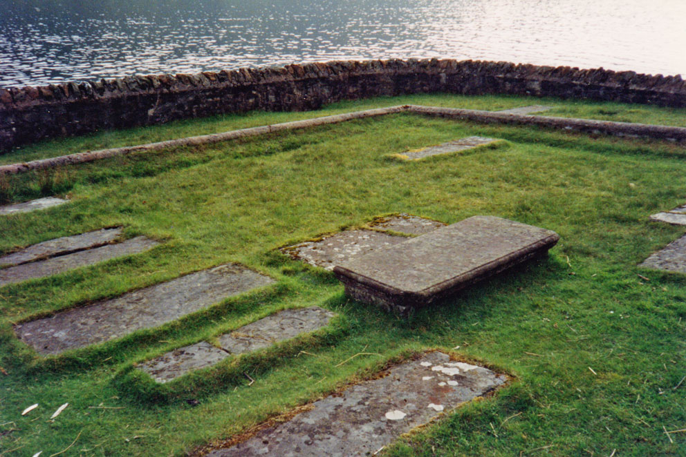
Writing the last post about the Magregors buried on Inchcailloch reminded me of another MacGregor burial ground 12 miles away in Loch Katrine. And yes, I did say 'in' Loch Katrine. 

Portnellen burial ground in Loch Katrine
In the 1800s Loch Katrine was dammed to provide water for Glasgow. In 1922 the water level was raised again, which meant the old burial ground at Portnellen would be submerged. Alasdair Alpin MacGregor, in his Book Wild Drumalbain (1927), has this to say about how the burial ground was protected from the rising waters:

The commissioners were bound to erect, previous to raising the level of Loch Katrine, a substantial stone wall around the burying-ground, on the identical site of the then existing wall... and prior to the raising of the level of the loch, they were required to raise the level of the ground within the said wall, and for a distance of 12 feet outside the same, to a height not less than six feet above the existing level, placing any gravestones in the same positions relatively to the raised surface, as they had occupied with reference to the original surface.

In 1993 my wife and I made the five-mile hike from Stronachlachar to Portnellen to see this 'island' cemetery in Loch Katrine. After walking across the narrow causeway we found about a dozen tombstones. None of the inscriptions were readable, but they are said to date to between 1699 and 1800.

Tombstones in the 'waterproof' enclosure
These tombstones lie some six feet above the actual graves - six feet of solid concrete. Alasdair Alpin wrote humorously write about this in Somewhere in Scotland (1935):

...the MacGregors buried there will require to be hefty fellows when Gabriel sounds the reveille, if they expect to break through the tons of cement which the Glasgow bailies have placed over and around their tombs by the shores of Loch Katrine.

See this CANMORE page for more on the 'island' burial ground at Portnellan.

Thursday, September 15, 2016

The Monks' Field - Boreray

Cladh Mhanaich, the Monks Burial Ground, is an enigmatic place. It is found on the island of Boreray, in the Sound of Harris, and is usually referred to as 'The Monks' Field'. It is a large tract of ground, dotted with a dozen or more large mounds. Aside from the mounds, any obvious signs it had been a cemetery were destroyed when the area was cultivated, long after its use as a burial ground.

Mounds on the Monks' Field 
Erskine Beveridge reported seeing a crossed marked stone here, along with two cup-marked stones. You can see a drawing of the cross-stone on the CANMORE page referenced below, but on my two visits to Boreray I was unable to find it. But I was able to find one of the cup-marked stones, which also had a deep font chiseled in it.

Cup-marked stone & font
It is odd that no excavations of the mysterious mounds has been done, as it would be interesting to know if there are any remains to be found. It was Martin Martin, writing in 1695, who reported that:

The burial place is called the Monks-Field, for all the monks that dyed in the islands north of Egg. Each grave has a stone at both ends, some of which are 3 and others 4 foot high. There are big stones without the burial place, several have little vacuities in them as if made by art; the tradition is, that these vacuities were dug for receiving the monks knees, when they prayed upon them.

Martin’s report has an interesting interpretation of the cup-marked stones - the vacuities being made to receive the knees of kneeling monks. The two 'vacuities' can be seen in the above photo (my knees fit perfectly - maybe I was a monk in a previous life).

The Monks' Field
The people of Boreray did not make use of the Monks' Field for burials. They chose a patch of holy ground on Aird a' Mhorain, a mile away on the shore of North Uist.

Cemetery at Aird a' Mhorain
Boreray is a beautiful, peaceful island; covered in short grass that makes for easy walking. It also has spectacular views over the Sound of Harris. Speaking of those views, on my first visit, several years ago, I saw an amazing sight. Far off on the western horizon was Boreray of St Kilda - I was seeing Boreray from Boreray. During my second visit, last May, the sky was hazy, and Kilda was not visible.

Boreray seen from Boreray (Hirta on left - Boreray on right)
See this CANMORE page for more on Cladh Mhanaich.

Looking to Boreray village from the Monk's Field

Tuesday, June 21, 2016

Garbh Eileach of the Isles of the Sea

During my cruise last month on Elizabeth G we visited the three main Garvellach Isles: Eileach a' Naoimh, Dun Chonnuill, and Garbh Eileach. It was only my second time to set foot on Garbh Eileach, the rough rocky island that gives the island group its name. From the landing jetty it is a short walk to Garbh Eileach House, the only habitable house on the island. No one was home, and it was locked up tight.

Garbh Eileach House
My first visit to Garbh Eileach was in 2002, when I chartered the catamaran Gemini for a day to take me to Dun Chonnuill and Garbh Eileach (see book 1, chapter 9). That trip was in late July, and the bracken was head-high, obscuring much of the ground. One thing I'd wanted to find on Garbh Eileach back then was an old cemetery called Cladh Dhubhan, but with all the thick vegetation I could not find it.

Cladh Dhubhan may have been the place of interment for some of the early ruling families of Dalriada. Around 660 AD, one of the kings was the son of Dunchad mac Duban (Duncan, son of Duban). So perhaps Cladh Dhubhan was named after the father of the king. Another possibility is that one of the Gaelic words for 'brave' is dhubhlan, so perhaps Cladh Dhubhan means burial ground of the brave. On my visit last May the bracken was only starting to sprout, and so it was easy to find the old burial ground; a rectangular enclosure behind the house.

Cladh Dhubhan
There is sparse information on Cladh Dhubhan. The most informative is this short mention in Patrick Gillies' Netherlorn, Argyllshire, and its Neighbourhood:

'On the island of Garbheileach there is a very old graveyard known as Claodh Dhubhan (the burying-place of Duban). More than one prince and certainly one king of Alban was called Dubh; and Dubhan seems to have been a common name; while in 927, Dubthach, son of Duban, fourteenth in descent from Conal Gulban the great-grand-father of Columba, became Superior or Co-arb in Iona.'

That is about all I can find on the mysterious burial ground of Dhubhan, although there is a CANMORE page on it, it is short and uninformative. Finding Cladh Dhubhan was one of many "I'll have to return to an island someday" promises I've made to myself over the years. It took 14 years to keep this particular promise, and it was good to return to this rarely visited Isle of the Sea.

Cladh Dhubhan

Monday, March 9, 2015

Kilvickeon - Ulva

One of the most beautiful spots on Ulva is the burial ground of Cille Mhic Eoghainn (Kilvickeon). It takes a bit of work to see it, as it's five mile walk from Ulva Ferry. Among others, buried here are many Macquarries and Livingstones of Ulva.

Cille Mhic Eoghainn (Kilvickeon) - Staffa in the distance
There are the ruins of two rectangular structures in the burial ground. Although they have not been specifically identified as chapels, they could be, as they are oriented E-W, and in the 1800s a bell was found here. The site is dedicated to St Ernan, the son of St Eoghan (Ernan's uncle was St Columba). Ernan has another site dedicated to him on the Ross of Mull, 12 miles to the south (the subject of the December 19, 2014 post).

Below are a few more photos of Ulva's Kilvickeon that I took in 2005. See this RCAHMS page for more on Kilvickeon, and this Flickr page for some photos of Macquarrie tombstones.


Friday, October 18, 2013

Kilchalmkil - North Uist

I love wandering around the old mound type burial grounds that you find in the islands. This one is Kilchalmkil (St Columba's) in Clachan Sands of North Uist. Sand and time have done their damage and there is no sign of the church that once stood here. The graves are laid out in lines, called roiligein in Gaelic (see page 159 of Bill Lawson's North Uist).


Sunday, March 24, 2013

Jura Journey - Day 4

Today we stop to explore two old chapel sites and their burial grounds. The first is Cill Chaluim Chille, St Columba's Church at Tarbert. The grass-grown foundation of the church can still be seen, and at one end of the burial ground is a 6-foot tall cross-incised standing stone. 
Cill Chaluim Chille - Tarbert
Church foundation and standing stone -  Cill Chaluim Chille
Cill Chaluim Chille
My company at Cille Chaluim Cille
To the side of the road, 1000 feet east of the site, is another, and much larger standing stone. It is easy to find, but not so easy to find is the holy well dedicated to St Columba. It is said to lie at the foot of the low cliffs east of the cemetery. I spent an hour searching in the boggy and fenced off terrain, but I could not find it.
Standing Stone at roadside - Chille Chaluim Cille
Our next stop, four miles up the road, is the burial ground of Kilchianaig at Inverlussa. No traces remain of the chapel dedicated to the mysterious St Cianag. But it is worth a visit both for its beautiful setting, and to see the tombstone of Mary MacCrain, who died in 1856 at the age of 128. Mary was descended from Gillour MacCrain, who died in 1671 and is said to have lived to the ripe old age of 180.

Kilchianaig at Inverlussa
Tombstones in Kilchianaig - Mary MacCrain's at centre
Mary MacCrain's Tombstone