Sunday, May 29, 2022

The Adventures of Hjalmar Bjorge - Season 5, Episode 5

 The Continuing Adventures of Hjalmar Bjorge
Season 5 - Episode 5 - Mingulay to Mull
Exploring the Isles of the West Cruise    April 18-May 2, 2022

From Mingulay we motored across the Sea of the Hebrides to Heisker Rock, where we were delighted by the sight of two minke whales. Peter Hill, author of Stargazing: Memoirs of a Young Lightkeeper, ends his book with a description of his last posting, which was on Hyskeir in 1973. Upon arriving via helicopter, he was greeted by the keepers, along with three other residents of his new posting.

And as we walked across the black lava towards the tallest lighthouse tower I had ever seen, three goats emerged out of the fine sea mist.


There have been no men (or goats) on Hyskeir since it was automated in 1997. (For more on Hyskeir see these posts: https://marccalhoun.blogspot.com/2014/11/scenes-from-heisker.html). The sea was mirror calm as we left Hyskeir and motored over to the west side of beautiful Canna, where we were planning to spend the night. The western cliffs of Canna were teeming with seabirds. 


Just as we rounded the corner to enter the harbour the Calmac ferry Lochnevis rocketed out of the harbour on its way back to Mallaig.


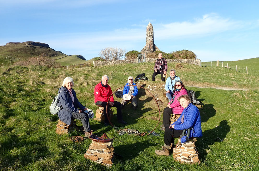
Once ashore I led the group to Rhu Church, also known as the Rocket Church due to its Irish Round tower belfry. It is always a delight to see it, especially on a bright spring afternoon with only wispy clouds floating overhead.


We then headed into the woodlands past John Campbell's grave to reach the Celtic Cross and the burial ground. Campbell's elegant tombstone reads:

Ian Latharna Caimbeul
1.10.1906    25.4.1996
Fear Chanaidh

Campbell died in Italy in 1996, and was buried there. But his body was returned to Canna in 2006. For the story of Campbell's life see The Man Who Gave Away His Island, by Ray Perman.


Our next stop was the bridge to Sanday, where some of us climbed to the high ground overlooking Sanday village. Just to the right of centre in the next photo you can see the Sanday Schoolhouse. The school dates to 1878, and is the subject of Kate Riley's book Canna School Dayshttps://acairbooks.com/product/books/non-fiction-books/history-non-fiction-books/canna-schooldays/


Just before returning to the ship a detour was made to Canna Prison. It is a mini-castle atop a dramatic stack that rises 80 feet above the western shoreline. The structure looks very precarious. I'd climbed it in my younger days, but not wanting to be responsible for the whole thing to come tumbling down, we settled for the view from below.


A fanciful watercolur of the prison was done by Richard Doyle in the 1870s. He titled it 'The Witches' Home'. No witches were soaring about, just curious gulls and kittiwakes.


When we returned to Hjalmar Bjorge we discovered Charlie had acquired prawns from a local fisherman. They made a delicious starter to the evening meal.


Overnight the weather drastically changed for the worse. We needed a place to shelter for the night, so Charlie took us over to the northeast corner of Ardnamurchan, where we anchored in Kentra Bay. In the morning we spent a couple hours ashore exploring the Singing Sands of Kentra. Similar to the Signing Sands of Eigg and Islay, if you scrape your shoes across the sands they make an odd, squeaking sound. Writing in 1844, the geologist Hugh Miller thought highly of the sound:

I walked over it, striking it obliquely at each step, and with every blow the shrill note was repeated. My companions joined me; and we performed a concert, in which, if we could boast of but little variety in the tones produced, we might at least challenge all Europe for an instrument of the kind which produced them.


A few of us made a stunning woodland walk above the sands, which starts with a warning sign about unexploded munitions in the sands. (Now they tell us!)


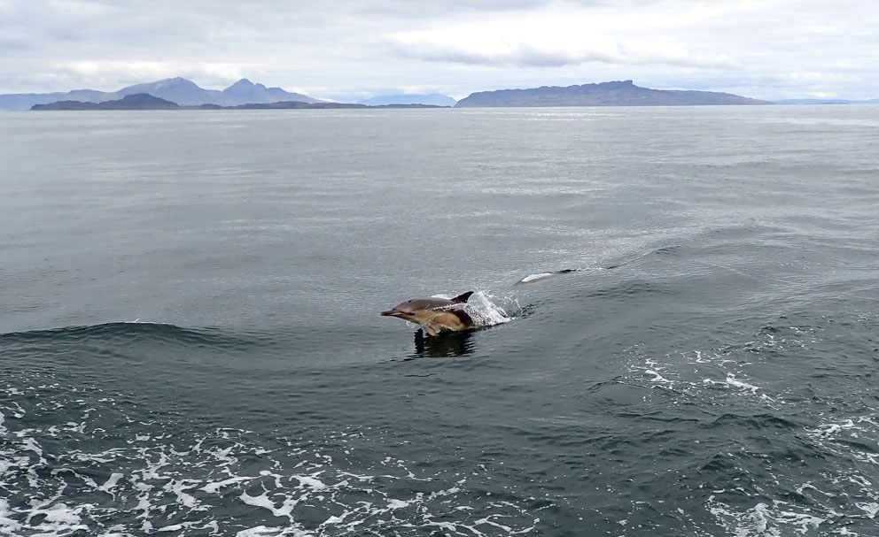
Fortunately, no one was blown up. (That would not have looked good on my Island Guider CV.) And so from Kentra we made our way to the Cairns of Coll, a spot known for whales. We did not see any whales, but we did see something fantastic - something in my thirty-plus years of Hebridean sailing I'd never seen. For over an hour, a large group of bottlenose dolphins bow surfed, and raced alongside the ship. There must have been nearly three dozen of them, gleefully playing with us, and you could tell they were happy to make us smile.


We ended the day on the pontoons of Tobermory Harbour. As we arrived I saw the sailing yacht Zuza tied up. She is a ship of memories for me. Many years ago I'd sailed on her around the Inner Hebrides and the Orkneys with Skipper Tim Wear at the helm. 


After a wander around the village we spent the night on the pontoons, then got an early start back to Oban in the morning.


By noon the next day, we were in Oban to say our goodbyes. It had been an exemplary trip, and we'd been blessed with (mostly) magnificent weather. I want to thank Charlie, Mel, and Steve for being a great crew, and Peter, Liz, Anne, Nigel, Clare, Wolfgang, and Debbie for being such great travelling companions. I hope to sail with you all again, someday.

Wednesday, May 25, 2022

The Adventures of Hjalmar Bjorge - Season 5, Episode 4

The Continuing Adventures of Hjalmar Bjorge
Season 5 - Episode 4 - Mingulay
Exploring the Isles of the West Cruise    April 18-May 2, 2022

After a night at the Monachs, we awoke to a morning of golden sunshine. The engines were fired up, anchor raised, and we set off to the south. Destination: Mingulay. Eighteen years had passed since I was last there, and I was looking forward to showing everyone its large puffin colony. Landing can be tricky, as the beach, which can look deceptively easy to land on, is subject to swells that can overturn a small boat. Charlie anchored just off the south shore of Mingulay Bay, where he set us ashore on the rocks near the ruin of the derrick platform that had been built in 1901. It was poorly built, and was not of much use. The struggling community finally left the island in 1912.


From the landing, we followed a track over to the old school, which has been renovated to house the ranger. Built in 1881, it saw its last pupil in 1910. The ranger was not in residence, so we had the island to ourselves.


Leaving the school, we followed 'Main Street' down to the village. Over the past century, drifting sands have half-buried the black houses near the beach. They are an odd sight, lintel stones in place a foot or two above the ground. It is as if the homes have sunk in quick-sand. The village burial ground lies just above the beach, an oval mound surrounded by a stone embankment. An early chapel dedicated to St Columba once stood on the site, and there are some fifty grave stones, most unmarked and covered by sand. 


The most substantial building here is the Priest’s House. Built of granite blocks, its ground floor had four rooms and a kitchen, which were used as quarters for visiting priests. The chapel on the upper floor, accessed by an external staircase, had been one large room, forty-five by twenty-five feet. It was in June of 1898 that Mass was first held here, celebrated by Father Allan MacDonald. There is a wonderful book about Fr Macdonald, Amy Murray’s Father Allan’s Island, written in 1920. The island referred to in the title is Eriskay, sixteen miles north of Mingulay. Fr MacDonald worked throughout all the Barra Isles until 1905, when he died from pneumonia at the age of forty-six. Murray’s book is a moving portrait of a man who gave his life to a people struggling to survive in these unforgiving isles in the sea.

Sadly, the Priest’s House is now a complete ruin. The roof blew off during a storm in the winter of 1996. When I'd last seen it, in 2004, the walls, and both gables, were still standing. It is now a pile of rubble, littered with fallen stones, shards of the slate roof, and chimney pots sitting oddly upright on the ground. 


To give you an idea of the destruction, the next photo is of the Priest's House in 2003.


Leaving the ruins behind, we headed across the hillside to the puffin colony. 


Once they got used to our presence, the puffins resumed their daily activities, which included a lot of squawking, kissing, and bringing back beak-fulls of sand eels to feed their pufflings. Puffins are known as Tammie-Norries in Shetland; papageitaucher in Germany (the diving parrots); and frilathios in Spain (the little friars, or, if you’re really hungry, maybe the little fryers). But I always think of them as the smiling birds. Not that they smile with their bright orange, red, and yellow bills. But if you watch people watching puffins, you’ll notice a lot of smiles.


It was a picture perfect day. The azure sky crisscrossed by high contrails. Were were now at the apogee of the cruise, and in the morning would start making our way back to Oban. But we'd have two more islands to visit along the way: Canna of Columba and Mull of the mountains.

Sunday, May 22, 2022

The Adventures of Hjalmar Bjorge - Season 5, Episode 3

The Continuing Adventures of Hjalmar Bjorge
Season 5 - Episode 3 - Scarp to the Monachs
Exploring the Isles of the West Cruise    April 18-May 2, 2022

After our wedding surprise in the Sound of Scarp, we set off for the Flannans. They lie 20 miles west of Lewis, and are home to a large gannetry. There had been a monastic hermitage there 1200 years ago, and its three beehive cells are in remarkably good shape. 


We motored into the sheltered bay below the lighthouse island. The tide was low, and we could see that the landing platform, and the stairs that ascend the island from it, were high above the waterline. It can be dangerous to get ashore here, and people have been injured in the attempt. On our 2019 trip we were able to land, but only after setting a rope so we could pull ourselves up to the beginning of the stairs. We did not have the crew complement to set a rope this time, so were unable to land. See this post for photos of the visit in 2019: https://marccalhoun.blogspot.com/2019/08/the-adventures-of-hjalmar-bjorge-season_12.html.


Charlie then took us on a tour around to the infamous West Landing, where the three keepers were washed away. Depending on the swell, landing here can be easier than the east side. But the problem is that a large section of the steps that ascend the cliff have washed away, so without ropes there is no way to ascend.


A look to the skyline above the landing showed two of the island's beehive cells, once home to monks, now home to puffins. The second photo below was taken in 2019, and shows the largest cell, a three-chambered oratory.


We then headed further west to take a look at the Roareim Gannetry. On the way we encountered a pod of white-sided Atlantic dolphins, including a stunning albino dolphin. Truly amazing!


Just off the Roareim Arch we came to a stop to admire the gannets filling the sky. It was raining guano, and a few of us took direct hits. (No matter how much I tried, I could not wash the gannet pooh stain out of my black coat until after I got home and put it through the wash twice). 


After a leisurely tour around the Flannans we turned south to make the five-hour journey down to the low-lying Monach Isles. We made an easy beach landing on Ceann Iar, the second largest of the island group. A sandbar once connected the Monachs to North Uist, but it was washed away during a storm in 1697.


We wandered across the primrose-dotted island to its small shieling village, then made our way to the summit trig-pillar. At 50 feet above sea-level it was not much of a climb.


We were unfortunate with the tide. When it's low you can cross over to the main island with its abandoned settlement, including a small museum in the old school. The following photo shows the flooded crossing.


I took a group photo at the trig pillar, then we returned to the ship. As we did there was some suspense in the air. Would we make it to Mingulay the next day - another 50 miles to the south - before the weather changed?