Sunday, May 31, 2015

Wanderings on Raasay - Kyles Rona & Eilean Tighe

After a week on Berneray (North Uist), my wife and I spent last week on Lewis. The time flew, and so I was not able to post on the walks and boat trips I did there. One walk I made was a spectacular overnight hike from Morsgail to Cliet Fhidigidh, then up past Loch Grunavat to Carinish. Along the way I visited a dozen shieling sites and several beehive cells, including Bothan Ruadh, which I believe is the most remote beehive cell on Lewis. Another exiting day was a boat trip to the tiny island of Eilean Fir Chrothair to see its little beehive cell. I also spent some time in the Mangersta bothy; a hobbit house of sorts hidden in a nook high atop the cliffs of Mangersta. I will post on all these once I get back home.

We're on Raasay now for a few days. Today I hiked from Arnish to Kyles Rona, and then crossed over to the tidal isle of Eilean Tighe. I will also post more on this when I get home, including some photos of Kyles Rona House and the house on Eilean Tighe, both once home to Julia Mackenzie, who writes about living in them in her book Whirligig Beetles and Tackety Boots. Until then, here are a few photos from the walk; one of the best on Raasay, which starts at the end of Calum's Road to Arnish.

Calum's Road
Start of the walk to Eilean Tighe
Looking north from Kyles to Eilean Tighe
The crossing to Eilean Tighe at low tide - with what's left of an old causeway
Looking south to Kyles (north end of Raasay) from atop Eilean Tighe - the tidal gap can just be seen in the centre
South Rona seen from atop Eilean Tighe - Big Harbour at the far left

Thursday, May 28, 2015

Wanderings on North Uist - Eaval & Dun an t-Siamain

For myself, Eaval was a tough nut to crack. Although it is only 1100 feet or so high, the approach to the foot of the hill requires miles of bog-hopping. In the summer of 2013 I was dropped on the shore near Burival, also known as Little Eaval, intent on climbing Eaval. That cut off a mile of bog, but I was only given three hours ashore, and when turn-around-time came I had only managed to climb to about 700 feet. I promised myself I'd return someday to make it to the top.

That promise was kept last week. But instead of repeating the approach to the hill from the north, I decided to climb it from Cladach Chairinis, three miles southwest of the summit. I made the climb in the company of Martin Margulies. Martin wrote the book Mhor and More about his walks on the Uists. Martin had advised me on the route to take on an visit to Glen Corodale I made three years ago (see the March 2013 issue of Scottish Islands Explorer).

From the road end at Cladach Chairinis, Martin and I headed east across the bogs; the sight of Eaval guiding us along. Without the mountain as a guide, the way back would be more of a challenge.

Across the bogs to Eaval
After two miles of bog- and loch-hopping we came to Loch Obasaraigh, where we got a close up look at its ring fort and dun before starting the climb.

Ring-fort and dun in the loch. The ring-fort is to the left (mostly submerged)
Dun & Ring-fort seen from 500 feet up the slopes of Eaval
It was a windy, gray day, but we were lucky in that there was no rain. Three hours after leaving the cars we reached the summit of Eaval.

Martin at the summit of Eaval
It was good to get to the top, especially as it had defeated me two years before. The next photo shows the view north: Burival (AKA Little Eaval) in the middle distance, South and North Lee in the far distance. (The northern approach to Eaval follows the shoreline at the base of Burival.)

Burival, South Lee and North Lee
After enjoying the view (and a snack) we descended to the southwest to the shore of Loch Dun an t-Siamain. I wanted to see if I could walk out across the causeway to the large dun that gives the loch its name.

Dun an t-Siamain from the slopes of Eaval
On reaching the shore we could see that Dun an t-Siamain was massive, as was its causeway made of giant boulders (one wonders how they got them in place). It was an easy stroll across the causeway to the fort.

Dun an t-Siamain
The approach across the causeway
Looking back to the shore - notice the large defensive wall where the causeway meets the fort
From the dun we started our way back to Chairinis. As we found out, without Eaval to guide the way, it is easy to get disoriented in the maze of bogs and lochs. After a wrong turn we managed to make our way back to the cars. Six hours afoot had left us with a thirst, but the proprietor of the nearby Temple View Hotel refused to serve us beer (since we were not residents), so we had to settle for tea and coke. It had been a great day on the hills, and I hope to hike with Martin again. You can read about his adventures on the hills of Uist in Mhor and More, published by the Islands Book Trust.

Sunday, May 24, 2015

Wanderings on North Uist - Dun Caragarry

A walk on North Uist, one I've wanted to do for a long time, is the circumnavigation of South Lee. About 10 years ago I made a long out-and-back day-trip to see the causewayed duns of Loch Hunder, which lie on the west side of South Lee. But there is another old fort, Dun Caragarry, high up on South Lee, that I did not have time to see. And so I decided next time I was on Uist I'd do a two-day hike around South Lee. I'd revisit the duns of Loch Hunder, see Dun Caragarry, and then walk along the north shore of Loch Euphort to find a campsite on the coast.

It's a long walk from the road to Loch Hunder, about three miles of rolling, soggy bog. With a full pack on, if I wasn't careful, a misstep meant sinking to my knees in muck. It took nearly two hours to reach Loch Hunder.

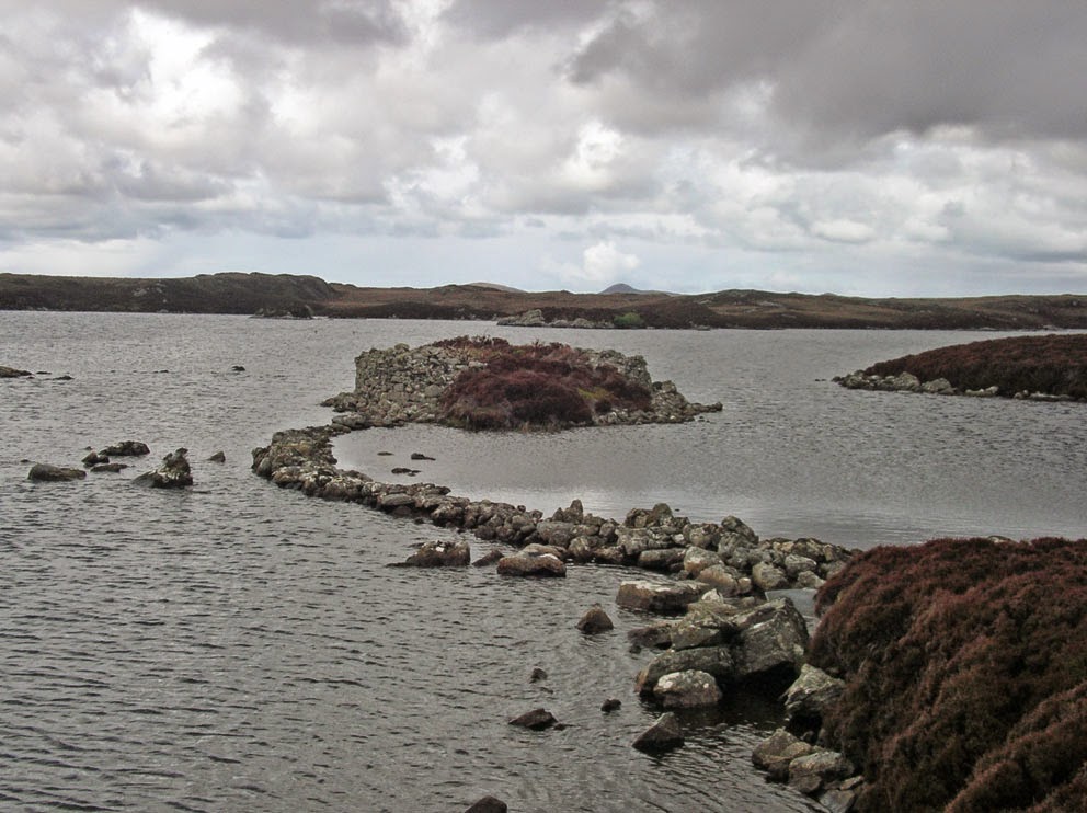
One of the duns in Loch Hunder
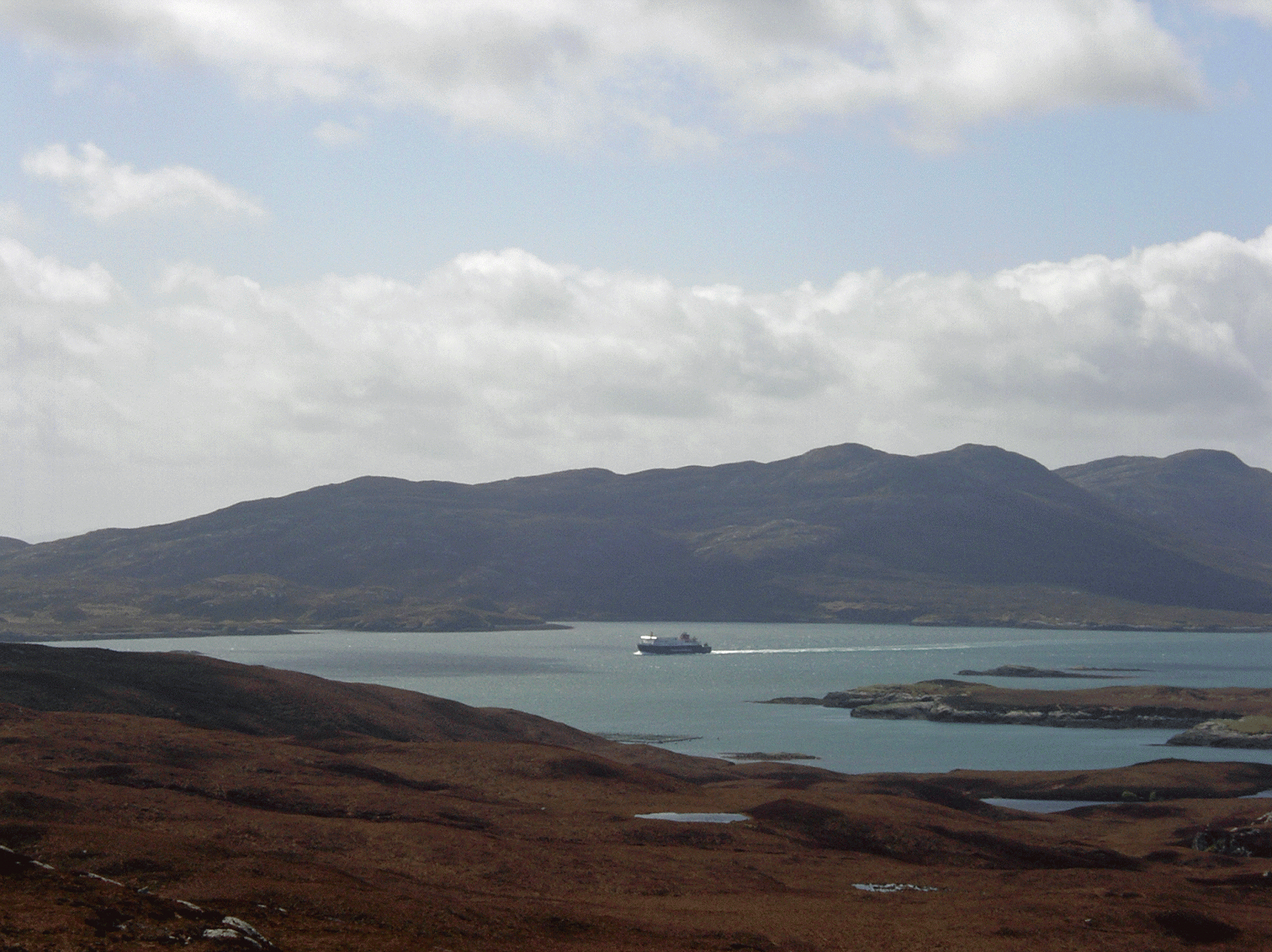
From Loch Hunder I was walking in totally new territory (for me). I reached the shore of Loch Euphort at Aird Bheag, and then followed it east to its narrow entrance from the Minch.

Eaval seen from the north shore of Loch Euphort
The narrow entrance from the Minch to Loch Euphort
Then it was time to climb, some 250 feet, up the shoulder of South Lee. There I came to Dun Caragarry. A dun that, at some point in time, someone built a beehive cell atop from some of the tumbled stones. The CANMORE page on the dun says the dome of the cell is intact, but it has collapsed since they visited it in 1965.

Dun Caragarry
Dun Caragarry - what's left of the beehive
From Dun Caragarry I descended east to the sea, and then followed the coast north looking for a good campsite. The wind was howling from the east, so a few great campsites I found at the beach of Mol Teiltein had to be bypassed, as they were too exposed. Then I came to a narrow inlet by a headland called An t-Aigeach. It was very sheltered, and at its head was a little beach where I decided to pitch the tent.

Home sweet home
Although it had been blowing, there'd not been a drop of rain all day. But just as I set up the tent the rain started to fall. It did not stop for 14 hours, and I spent all evening and night hunkered down in the tent. Fortunately I was so tired from the hike that I managed to sleep through most of it. The rain stopped at 7am, I packed up, and set out to the west to climb the pass between North and South Lee.

The pass was deceptive. From a distance it looked like there was an old peat track that would make for an easy hike (next photo). 

Looking up the east side of the pass
But on closer inspection it was not a track. It was a giant bank of heather covered peat, with swampy ground on either side. I had no choice but to follow it to the top of the pass to Loch Lee. From there a similar peat bank dropped down the west side of the pass to the vast moor I'd crossed the day before. 

The west side of the pass
Although I was a long walk away from 'civilization', the town of Lochmaddy was only a mile away across Loch nam Madadh. I was fortunate, in that the sun was out and there was no rain, and I had a brilliant walk back to the road. My wife picked me up, and then we had fish & chips at the Lochmaddy Hotel, some of the best we've ever had.

Lochmaddy seen from the moorland below North Lee
Before we headed up to Lewis there was one more walk I wanted to do on North Uist; I wanted to climb Eaval. I'd started to climb it on an August afternoon two years ago, but I ran short of time and had to turn back. Eaval would definitely be climbed this time, and even better was that I was going to climb it with Martin Margulies. Martin wrote the book Mhor and More about his many walks on the Uists. I was looking forward to meeting him and ascending Eaval.

Thursday, May 21, 2015

Wanderings on North Uist - Taigh Talamhant

We made the transatlantic crossing a week ago, and are now up on Berneray. Tried Icelandair for a change, as they have flights from Seattle to Glasgow via Reykjavik. Nice flights, but our checked bags, including all my camping gear (except my boots -which I always carry on), missed the connection. They did manage to expedite things, and our luggage arrived in Oban the day before the ferry left for South Uist.

The cottage we're staying in on Berneray is called The Smiddy, It is in a beautiful location overlooking the machair at Borve. 


The property is run by Gloria MacKillop. We last saw Gloria in 2001, when her and her husband, 'Splash', were doing B&B. I first met Gloria and Splash when I stayed here before my first trip to St Kilda in 1999 (see book 2, chapter 14). Splash passed away in 2009, and Gloria finally stopped doing B&B last year. Yesterday my wife and I paid a visit to his grave.


The weather in the Western Isles has been miserable this week: blowing and rain/hail mix. The forecast stone outside the Berneray shop is wet and swinging. Hopefully it won't go missing later this week.


A few days ago the storms abated and I went for a hike to Taigh Talamhant, a souterrain with three entrances that DDC Pouchin-Mould wrote about in West Over Sea. It is described as being quite roomy, and the entrances large enough to still get into. So I threw a couple of flashlights in my pack and set out to find it.

The souterrain lies on the west side of Loch Thacleit, three miles northeast of Lochmaddy. To get there I drove the single track to Lochportain, and left the car in a lay-by near Loch an Duin. From there I huffed and I puffed my way south to the summit of Beinn Thacleit. It's only about 400 feet high, but the ground was a soggy mush, and I had to navigate around several lochs. At the top I was rewarded with a great view over to Lochmaddy.

Lochmaddy seen from Beinn Thacleit
Ferry from Uig (Skye) arriving at Lochmaddy
From Beinn Thacleit I descended to Loch Thacleit and crossed the isthmus between it and Loch Grota. 
Loch Thacleit
I found the first of the three entrances to the souterrain nestled in a small depression halfway up the west shore of Loch Thacleit. I dug the flashlights out of my pack, and made my way down to the entrance.
The first entrance
But it was not to be. With all the rain the souterrain was half filled with water. Without a snorkel there'd be no way to get inside. I wandered over a small rise to find the other two entrances, hoping they'd be drier.

The second entrance
But they were'nt. There was no way to get inside, and I had to be content with sticking my head in a few feet  - next time I'll have to bring scuba gear. I was disappointed not to get inside, but I'd still had a good walk on the hills with not another person in sight. See this CANMORE page for more info on Taigh Talamhant. My next walk will be an overnighter to the fort of Dun Carragary, high on the slopes of South Lee.

Thursday, May 7, 2015

Ewen Little Head

Crannogs, man-made island strongholds, are interesting structures. The first I remember seeing is possibly the most seen crannog in Scotland. It lies in Loch Sguabain (Mull), a quarter-mile off the A849, and is easily seen from the tour buses that take thousands of people every year to Iona.

This particular crannog is more interesting than most. It has a name, and some of its history is known. Called 'Caisteal Eoghainn a' Chinn Bhig' (the castle of Ewen little head), it was last occupied by Ewan Maclaine in the 16th Century. You can read about Ewen, and how he lost his little head, in Thomas Hannan's The Beautiful Island of Mull, and in Alasdair Alpin Macgregor's The Ghost BookEwen was killed during a battle nearby (some Maclean/Maclaine infighting), and his head was cut off.

Macgregor includes Ewen's tale in chapter 3 of The Ghost Book - a chapter entitled  Haunted Lochbuie - because Ewen's headless ghost, riding atop a horse, is said to haunt Lochbuie House and the surrounding area. Seeing (or hearing) Ewen ride by was said to mean there'd be a death in the Maclaine family. Ewen was said to have been heard the night that Murdoch Maclaine, the 22nd chief, died in 1909. See the December 9, 2014 post for more on the death, and funeral, of Murdoch Maclaine. And see this CANMORE page for more on Ewen's Fort.

Ewen's Fort - Loch Sguabain
A mile and a half northeast of Loch Sguabain, on the hillside below the ruin of Torness cottage, you will find a small cairn that marks the spot where Ewen was decapitated in the battle of Glen Forsa. Every time I pass by I like to stop and add a stone to this memorial to Ewen Little Head, the Headless Horsemen of Lochbuie.

Ewen's Cairn - Glen Lussa