Showing posts with label Vatersay. Show all posts

Thursday, October 22, 2015

Rubh 'Aird-Laoigh - A Hidden Corner of Vatersay

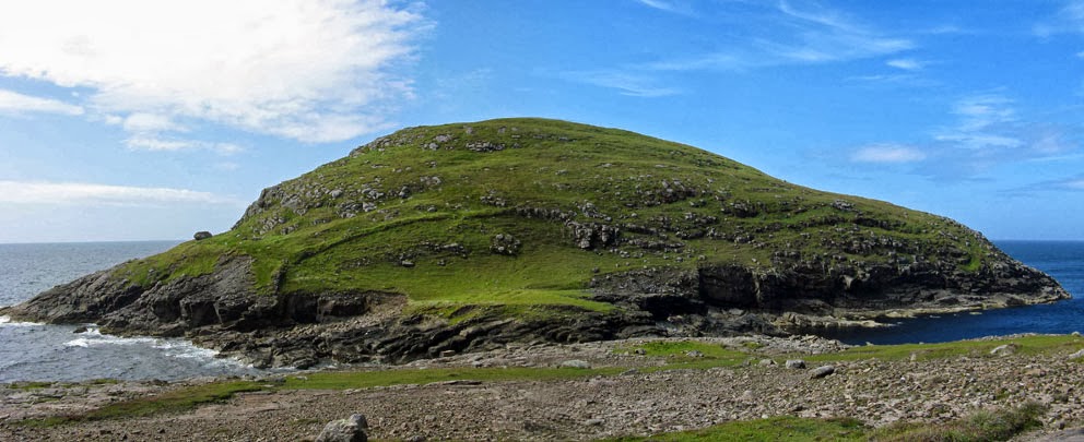
A hidden corner of Vatersay that I've visited twice over the years is Rubh 'Aird-Laoigh. I'm not sure of the translation, but it may mean something like the headland of the tall calf. It is a spectacular place, a rocky headland just beyond a white-sand beach, where tremendous breakers roll in from the open Atlantic.

Route to Rubh 'Aird-Laoigh
The headland is hidden only in the sense that you can not get there by car, but is easy to reach on foot. Take the bus to Vatersay from Castlebay and get off at the bus shelter a half-mile after the causeway. From there follow the side road west a half-mile to a white-sand beach called Traigh Bharlish. 

Traigh Bharlish
Where the track ends above the beach you turn left to go through a gate to reach the open hillside. Keep going a short way west to reach Rubh 'Aird-Laoigh.

Rubh 'Aird-Laoigh
On my last visit to the headland I had to tip-toe past a herd of cattle. Slow-going was required because a big old bull, with a ring in his nose, was watching my every step. Several calves were grazing nearby and, appropriately, considering the name of the place, they were quite tall.

Under observation on Rubh 'Aird-Laoigh
The headland is a beautiful place. And if you are in the mood for more coastal hiking you can carry on westwards to the fortress islet of Birusalum before climbing 600 feet to the top of Heishibhal Mor, the highest point on Vatersay. From there a scenic traverse can be made to the top of Heishibhal Beag before dropping down to the road near the Vatersay Community Hall where you can catch the bus back to Castlebay. If you make this walk it will be one where, chances are, you'll not see another soul, even on a beautiful summer day.

Rubh 'Aird Laoigh

Tuesday, April 21, 2015

High Atop Vatersay

Here are some views that await those who take the time to ascend Heishaval Mor, the highest point on Vatersay.

Atlantic breakers rolling into the West Bay - Sandray in the distance
A calm East Bay - the old schoolhouse (now self catering) at lower left
A late afternoon view to Castlebay
The Vatersay Causeway
The next photo was a poor attempt to duplicate Robert Adam's photo of the same scene in 1922. (See this Univ. of St Andrews page - photo item # RMA-H-1061.)

Snowy east slopes of Heisibhal Mor
The last view is of Muldonaich, an island I hope to visit someday.

Looking east to Muldonaich

Saturday, January 17, 2015

Vatersay Pay and Display

This is what happens on Vatersay when you forget to Pay and Display.

East Beach Car Park, Vatersay

Monday, June 9, 2014

Vatersay of the Beaches - 4

We'll end our tour of Vatersay's beaches with a visit to Traigh Caragrich and Traigh Uinessan on the northwest tip of the island. They are easy to reach. Once over the causeway drive a mile and a half, turn left, and then follow the road past the church of Our Lady of the Waves and St John. Continue to the bus turnaround at the end of the road and park on the turf. Standing here is Taigh Sanna, a self catering house in a wonderful location. Traigh Caragrich is a 30-second walk to the east. 

Traigh Caragaich at road's end
Once past the beach, a five minute walk to the east takes you to Uinessan. Although many references say Uinessan is a tidal island, I have visited it several times over the years, and never once checked the tides beforehand. Perhaps, like the tidal isle of Erraid, it is only isolated at extremely high tides.
Traigh Uinessan
On the east side of Uinessan you will find a low mound. On it stands the ruin of Cille Bhrianain, the chapel of St Brendan. Buried there is Mór nan Ceann, Mary of the Heads, the wife of a MacNeil chief. Her name is said to have come from her preference for fresh ox tongue, a once-a-day habit that cost the lives of several hundred cattle a year. Another version of her name says that she beheaded two of her two stepsons so that her son Ruari would become the Chief of the MacNeils. 

Mary wanted to be buried within sight of her native island of Coll, and so it was decided to bury her on Uinessan in a standing up position, facing southeast (towards Coll). It was a foggy day when they buried her, and when the fog cleared they discovered that the nearby island of Muldonach blocked the view to Coll. There were some who wanted to move her, but the chief decided to leave her buried where she was - or so the story goes.

The ruin of Cille Bhrianain (on the mound at centre) - Castlebay in the distance
Whats left of the chapel
Here we end our tour of Vatersay's less-visited beaches. Next time you are on Barra, pack a lunch, get youself over to Vatersay, and then spend a few hours on one of these remote beaches. Chances are you will have it all to yourself.
Looking toward Castlebay from Cille Bhrianain

Friday, June 6, 2014

Vatersay of the Beaches - 3

Traigh Bharlish may be Vatersay's least visited beach. The locals know it well, and call it Caolas Beach, but most tourists never see it. I visited the beach by taking the bus from Castlebay to Vatersay, and then climbing to the top of Heisival Mor, the highest point on Vatersay. From the top I had a great view down to Traigh Bharlish (first photo) and the Vatersay Causeway (second photo).

Traigh Bharlish seen from the slopes of Heishival Mor
Vatersay causeway seen from the slopes of Heishival Mor
From the top of Heishival Mor I descended to the sea to take a look at the fortress isles of Birisalum, and then headed north to Traigh Bharlish. It is an amazing beach, and there was not another soul around. From the beach, a mile and a half hike took me to the causeway, where I caught the bus back to Castlebay. Next time we'll see the two small beaches that lie on the northeast tip of Vatersay.

Traigh Bharlish seen from the south
Traigh Bharlish seen from the north
Traigh Bharlish seen from Traigh Bharlish

Thursday, June 5, 2014

Vatersay of the Beaches - 2

Just west of Traigh Eorisdail is Traigh a' Deas, the south beach of Vatersay. When I first arrived, I had the beach all to myself. But after spending an hour there, two other people arrived intent on taking a swim (second photo). I left them to it - the water was too cold for me - and hiked to the top of Ben Rulibreck, the highest point on the SW corner of Vatersay. From the top I had a wide, panoramic view over most of Vatersay (third photo). Next time we'll head north to see beautiful Traigh Bharlish.

Traigh a' Deas seen from the east
Traigh a' Deas seen from the west
Looking north from Ben Rulibreck - Heabhal (on Barra) in the distance

Tuesday, June 3, 2014

Vatersay of the Beaches - 1

Vatersay is known for its wonderful beaches. There are seven beaches, but the vast majority of visitors only see the two largest: Traigh Siar and Traigh Ear, which are near the road. The five other beaches, going sunwise around the island, are Traigh Eorisdail, Traigh a' Deas, Traigh Bharlish, Traigh Caragrich and Traigh Uinessan. 

I first visited Traigh Eorisdail and Traigh a' Deas during on a circular walk around the south end of Vatersay. At the time I did not know that these two beaches were worthy subjects of a walk on their own. I made the walk because I wanted to get as close to the island of Sandray as I could, as my plans to get to Sandray, which lies a half mile to the south, had been foiled by a week of bad weather.

The first photo shows several kayaks ashore on Traigh Eorisdail, and in the distance you can see Sandray shrouded under a bank of dark, menacing clouds. Above the beach (second photo) are the ruins of the settlement of Eorisdail. It is an eerie place, just the gable ends of the houses still stand. Apparently it was common, in the early 1900s, to build stone gables, and use timber for the walls. No roads lead to Eorisdail, and it was finally abandoned in 1966. Next time we'll take a look at nearby Traigh a' Deas.

Kayaks on Traigh Eorisdail
The ruins of Eorisdail

Monday, February 10, 2014

A Barra Funeral

In June of 2010 my wife and I stayed for a week at the Craigard Hotel in Castlebay. The hotel is set in a great location, high above the harbour next to the Our Lady, Star of the Sea Church. One day we noticed that a hearse had pulled up to the church, and we were told that a funeral procession would be heading to the cemetery on Vatersay. Since we had planned on visiting Vatersay that day, we decided to get there in advance of the procession so that I could get some photos of the cars driving across the causeway.

Hearse at Our Lady, Star of the Sea
Here we see the procession crossing the Vatersay Causeway.
Across the causeway - 1
Across the causeway - 2
After the procession passed over the causeway my wife and I followed it across Vatersay's single track road. It was probably the most traffic the island had seen in a long time.

The procession winds along the single track to Vatersay's East Bay
The coffin was then carried across the machair into the Vatersay Burial Ground.

Vatersay Cemetery
At the time I had no idea who the funeral was for. Two years later, in 2012, I returned to find the grave. It was for a Jessie Campbell, who had died on the last day in May, 2010; just two days before we had arrived on Barra. Even though we did not know her, it was a privilege to have witnessed her funeral.

Saturday, October 5, 2013

Biruaslum Fort

Many people visit Vatersay, but few take the time to walk out to see the fortress islet of Biruaslam. And they should, for the walk to see it is one of the best hikes on Vatersay. I caught the bus at the Castlebay Post Office, rode it to Vatersay Village, and then walked north along the white sands of the West Beach. After paying my respects to the Annie Jane monument, I stopped in at the community centre for tea and a scone.

Fully refreshed it was time to do some work, and so I zig-zagged up the southern slopes of Heishibhal Beag. From the summit there was an expansive view over all the Barra Isles. But the view was even better after I climbed another kilometer west to the top of Heishibhal Mor. From there a gradual descent westwards took me down to the sea dyke that separates Vatersay from the island of Biruaslum. The cliff fort that occupies the eastern side of the island can be seen in the first photo.

Biruaslum Fort

I thought I might be able to get onto the island to see the fort up close, but the channel that separates it from Vatersay proved far too wide to jump. 
The Sea-Dyke between Vatersay and Biruaslum

From Biruaslum a coastal walk north led to the beach of Traigh Bharlish (next photo). And from there an easy walk east led to the causeway, where I caught the bus back to Castlebay. It was an amazing day out, and one of the best walks in the Hebrides.

Traigh Bharlish

Friday, February 22, 2013

A Summer View to Vatersay


This is a very transitional photo from that of the previous post; both in view, seasons, and centuries. It is Vatersay seen from the summit of Sandray on a warm summer day in 2012; taken 14 years after that snowy sight of Sandray seen from atop Vatersay on a cold winter day in 1998. The moonscape foreground is the glacier-scraped flat top of Sandray.

Tuesday, February 19, 2013

A Snowy View to Sandray


I was rewarded with this view after a cold, wet trudge up the northern slopes of Heisabhal Mor on a snowy February afternoon. The snow-capped island to the south is Sandray.