Thursday, June 27, 2019

The Hamnavay Track and Beyond - Day 3 of 3

The wind died around midnight, which would usually mean the midges would be out in force. But fortunately it was cold, too cold for the wee beasts, so I was able to take my time packing up. The shieling hut had been a great campsite, one I hope to return to someday.


Just as I set out I looked towards the northern hills to see a St Andrew's Cross high in the sky. A sure sign I'd vanquish all foes who'd come my way; be they midges, bogs, rivers, or gamekeepers.


The road at Kinlochrog was five miles to the northeast. My wife was going to pick me up there at 3pm, so I could take my time and see a few shielings I'd not visited before. The most interesting was Gearraidh Uidh Phaill, just to the west of Loch Cro Criosdaig. The loch's name means loch of the Christian enclosure, so there was probably a monastery here. At Gearraidh Uidh Phaill I found the remains of two collapsed beehive cells set at the base of a rocky knoll. 


From Gearraidh Uidh Phaill I set out across the open moorland. It was sunny, and quite beautiful. The last time I had crossed this area was on a bleak, wet, and gray day, and all I'd wanted to do was get across it as fast as possible. But this time it was a joy. The next photo gives some sense of how spectacular this unpopulated, and rarely visited terrain is.


The final stretch of the hike took me to Morgail Lodge, at the north end of Loch Morsgail. From there an easy walk on the tarmac track led to Kinlochrog. Just as I reached the public road my wife drove up. She must be able to read minds - she kissed me, and then handed me a cold beer.

Monday, June 24, 2019

The Hamnavay Track and Beyond - Day 2

In the last episode we spent a windy night in a small tent atop Cleit nam Bothan Aird, the rocky eminence of the high bothies (beehive cells). 


Bothan Aird lies a mile east of the head of Loch Hamnavay. Unless you have a friend with a boat, it is a 12 mile walk to get there via the Hamnavay track, or an 8-mile bog-slog from Morsgail. The previous day I'd made the 12-mile hike via the track, a walk I did not want to repeat, so the plan was to end the hike by heading east to Morsgail over the next two days.

Where the Hamnavay Track reaches the sea
The goal for this day was to make it to Upper Fidigidh, visiting, along the way, the shieling sites of Gearraidh Aineabhal and Lower Fidigidh.


Although it had been a windy night, I was lucky, as it had not rained. So after a bit of a lay-in I packed up my gear, and after strapping the tent to the pack set out to the north.


Re-energized after the night's sleep, it was an easy hike down into the glen between lochs Gruinebhat and Bodabhat.


Then I started north up the pass between the two summits of Aineabhal (the notch you can see at the upper left in the next photo). Visible in the foreground of the photo is the stump of a WWI telegraph pole. A series of them once crossed the moorland from Hamnavay to Kinresort and Morsgail.


After descending from the north side of the pass I came to the shielings of Gearraidh Aineabhal. There are three of them: Gearraidh a' Stigh Aineabhal, Gearraidh Meadhonach Aineabhal, and Gearraidh a' Muigh Aineabhal (Inner, Middle, and Outer Aineabhal). The shielings were all placed such that the residents could see the head of Loch Hamnavay, a mile to the west.


In total, between the three sites, there were ten shieling huts, including three beehive cells. I always like to crawl into these beautiful structures and, if there are no midges, take a short snooze.  It was too cold for the midges, so I had a brief nap.


From Aineabhal it only took 15 minutes to descend down to the Hamnavay River. I was a bit concerned that I might not be able to cross the river, which would mean having to walk a mile west to the bridge near the lodge. But the river was low, and there were several spots where it would be easy to ford. As it turned out there was no need to ford, because I was able to use a board that spanned one of the salmon weirs as a bridge.


Once over the river I turned east to follow the fisherman's path to Loch na Craobhaig. Portions of the path have wood planks that make the going easier across the soggy moorland. Although many of the planks are rotted, they still speed your progress east.


At a point just west of Loch na Craobhaig (the bushy loch) I turned north towards Fidigidh. Here there are several 'false' beehive cells, the grouse shooting butts I described in the April 16th post.


I was now in Fidigidh, and as I made my way north I took a look at each of the many shielings of Fidigidh Iochdrach (Lower Fidigidh) and Fidigidh Uachdrach (Upper Fidigidh). At Upper Fidigidh my quaking legs told me it was time for a very long break, say eight hours or so. The time had come to set up camp. (See the May 31st post where I described how the wind made setting up the tent difficult, and how I ended up pitching it inside a roofless shieling.)


Sunset on that May evening was at 10 pm, and it was still bright at midnight when I got up to take care of some urgent business. The wind died out around 3 am, and I had a lazy lie-in, stepping put of the tent at 8 am to find a calm, sunny morning. I would have an easy day ahead of me, as the road at Kinlochrog, where my wife was going to pick me up, was only six miles to the northeast. Along the way I would visit several of the shielings that dot the moorland near Loch Cro Chriosdaig, the loch of the Christian enclosure. A name that implies there was once a monastic settlement in the area. 

After breaking camp I set out to the east with the sunlight for my load (and the full pack). You have to pay attention to every footstep as you cross this boggy terrain, which was very hard to do. The reason was I was distracted by an amazing sight: the stunning views across the loch-studded moorland to the high hills of Harris.

Friday, June 14, 2019

The Hamnavay Track and Beyond - Day 1

I have posted before on the Burma Road of Lewis, also known as the Hamnavay Track (see the Feb 17, 2015 post). It is a 10-mile unpaved road, gouged out of the moorland and hills in the interior of Uig, that leads from Ardroil to Hamnavay Lodge.


I have walked this road about 10 times over the past 20 years. After each time I tell myself I'll never walk it again. It is a hellish grind, this long and winding road, with its seemingly never ending series of false summits. It saps your strength - especially if you are carrying a pack with 30 pounds of gear to camp for several days. But I always seem to end up walking it again, as it is the quickest way to access the remote interior of Uig.


And so, last month, I decided to walk it yet again, in order to visit some of the shieling sites that dot the moorland in the Ardveg. An hour into the walk I came to the gate that was installed when they built the road in 1999 to prevent riff-raff (like me) from driving the road. On all my previous walks the gate had been locked, and so I was surprised to find it propped open.


Another surprise awaited two miles past the open gate: it was another gate, one that had been installed since my last walk this way in 2017. This gate was locked, but I was happy to see they'd provided a bypass for walkers around one of the posts. I had no idea at the time why they'd built this second gate. But I was to learn why in a few days. (I do not know the details, but it seems the old gate blocked access someone legally had to the nearby moorland lochs, so they have to move the road blockade a couple of miles south.)


As I passed around the locked gate I wondered what other surprises awaited; I would have to wait three hours to find out, as that's how long it took to climb the pass (1000 ft), and then make the descent to Loch Tamnavay.


The surprise was yet another new, and locked gate, blocking the track just before it reached Hamnavay Lodge. Not only was it locked, but there was no way for a walker to get around it. If I'd had wire cutters I'd have clipped the barbed-wire on one side of the gate to get past, as it in not legal to block access like this. But lacking cutters, there was nothing to do but climb the nearly 5-foot-high gate. I have always respected their privacy when walking in this area, staying as far from the lodge as possible, and I have always checked with the Estate Manager when passing this way in hunting season, and so this gate made me mad. Respect has to be two ways, and this onerous locked gate was a blatant sign of disrespect.


Once over the locked gate, and past the lodge, I crossed the footbridge over the Tamnavay River. Then a climb up the hillside to the south led to Loch Grunavat. After seven hours of hiking I was nearing my destination for the night, the beehive cells of Bothan Aird: a place I'd been to before, but had never spent the night. 

From Loch Grunavat I followed several of the petrified WWI telegraph poles to the east, then headed up the slopes of Cliet nam Bothan Aird.


Near the summit of Cliet nam Bothan Aird I came to its two beehives cell, one of which is 100% intact. I had been considering sleeping in the cell, but its floor was covered with stones and wet moss, so I pitched the tent next to the cell. 


I then enjoyed supper, and the can of beer I'd lugged for 12 miles, while sitting at the summit of the hill. The cell-dwellers here had a fantastic view west to the Atlantic and the island of Scarp.


The night was exciting. Around midnight a storm blew up, and I was glad I'd securely staked down the the tent. After putting in earplugs to drown out the howling wind, I managed to get back to sleep. I would need the rest. The plan for the next day was to head farther inland to spend the next night at Fidigidh, a cluster of shielings, some used up until WWII.

Friday, June 7, 2019

Beinn a' Bhoth - The Mountain of the Beehive

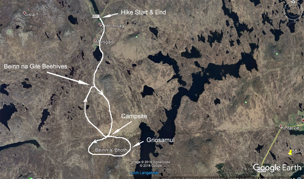
One of the overnight excursions I made last month on Lewis was to pay a visit to Beinnn a' Bhoth - the mountain of the beehive cell. Although it is only 1000 feet high, it is a challenge to climb as it it lies five miles south of the road at Kinlochrog.  Five miles of ups and downs over boggy terrain.

So why, you ask, did I want to climb this remote hill? It was because of a cryptic note in Donald MacDonald’s Tales and Traditions of the Lews; a book posthumously published by his wife in 1967, six years after his death in 1961. (A paperback version was published by Birlinn in 2000.)  The book includes a short chapter entitled The Beehive Huts on the Uig and Harris Hills, which ends with the following sentence: On the side of Ascleit are a group of boths (beehive cells) still with the roofs on and one on Beinn a’ Bhoth.

Beehive cell on Ascleit (2018)
I had easily found the Ascliet cells on a walk in 2018 (see the September 7, 2017 post). But the cell MacDonald mentioned on Beinn a’ Bhoth was a complete mystery. Beinn a’ Bhoth (the mountain of the beehive) is 1000 feet high, and spans over two-square miles. The CANMORE database does not show any sites on the hill. Neither does the 1854 OS map, which is usually a good source to find ruins. 

I knew I would not have the energy to walk over every square foot of the hill, especially after the long trek in, so I spent some time looking at the aerial photography overlays available on CANMORE. In scanning the images I noticed what looked like a small pimple high on the hill—possibly a beehive cell. During the walk described in the above referenced post I had passed right below it. In addition, I also noticed what appeared to be an intact cell at Griosamul, a mile east of the hill. And so a return to Beinn a’ Bhoth became a must. It would require a round-trip walk of 12 miles from Kinlochrog. A bit far for a day-trip, so I decided to make it an overnighter. 


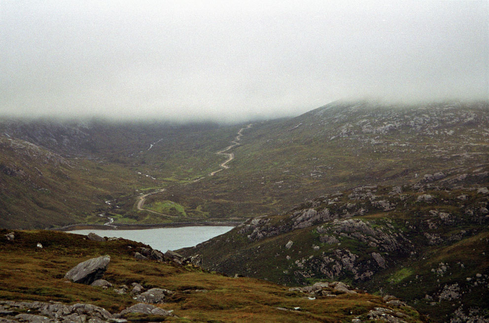
I was on familiar territory as I headed south along the track to Morsgail Lodge, crossed the footbridge just before the lodge, and then traversed down the eastern shore of Loch Morsgail. At the Beinn na Gile beehives I turned southeast to follow a very old track up to the saddle between the summits of Shèlibridh and Cleit Shèlibridh. From the top I had a clear view south to Beinn a' Bhoth.

Beinn a' Bhoth (at centre) seen from Shelibridh
From Shèlibridh an easy descent south took me to the shielings of Airigh an-t-Sluic. This was where I would camp for the night in a few hours. To lighten my load for the rest of the day’s hiking I dropped my tent and sleeping bag next to one of the ruined shielings. Looming above me was Beinn a’ Bhoth, the mountain of the beehive.

The north and west sides of Beinn a’ Bhoth are a mix of steep, grassy slopes and craggy cliffs. I entered the grid coordinates into my GPS of the object on the aerial photo, and let the GPS guide me to it. As I climbed a grand view west to Loch Reasort and the Atlantic gradually opened up. When the GPS indicated I had 100 feet to go, I saw something, and gasped. Lying half enveloped in heather, moss and grass, stood a very old beehive. (Sorry, but I am not going to include a photo. I am saving it for a book on the beehive cells of the Hebrides, which I hope to get published later this year.)

The view west from Beinn a' Bhoth to Loch Reasort and Scarp
The cell had a spectacular view west to Loch Reasort and the Atlantic, with the island of Scarp on the far horizon. A more perfect place to spy on unwanted arrivals by sea would be hard to find. I regretted leaving my tent at Airigh an t-Sluic, as this would have been a memorable place to camp. But it was for the better, as the severe winds I experienced that night would have been much stronger at this elevation.
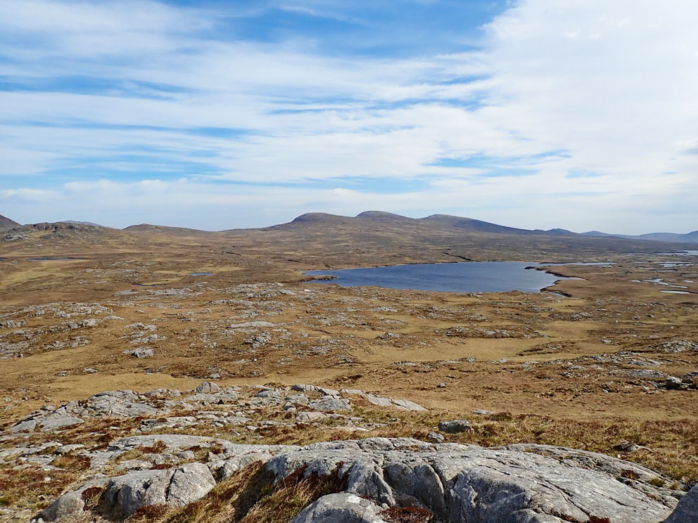
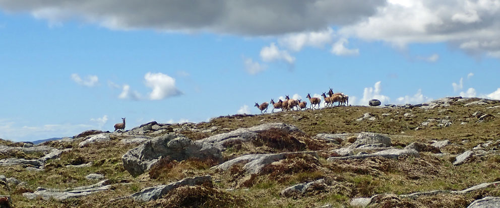
The sun relentlessly blazed down as I left the cell to spiral up to the summit. A joyful surprise startled me when I crested a small rise. On its far side was a large pond; in it a dozen deer lazily enjoying a cool soak. When they noticed me they jumped up in unison, causing sprays of water to erupt into the air. Then they elegantly sprinted away at breakneck speed. Within five seconds the only sign of their presence were ripples of water slowly spreading across the surface of the pond. By the time I got the camera out they had reached the ridge top above me.


Look north from the summit of Beinn a' Bhoth
I took some time to enjoy the 360-degree view from the summit of Beinn a’ Bhoth, then headed down its grassy eastern slopes. It was a 300-foot drop to the boggy floor of Gleann a’ Ghàraidh (they are all boggy), where I forded the Abhainn Gleann a’ Ghàraidh. As I ascended the hillside east of the stream a shout of joy burst forth—which scared a snoozing grouse out of the heather. At the shieling settlement known as Griosamul stood a compact triple beehive cluster, one of the cells 100% intact. It was the other cell I'd seen on the aerial photo, marked on the map as Both a’ Ghriosamul.

There were once three beehives clustered close together atop a mound at the center of the site, two of them interconnected. Only one of the three stands complete, and it is one of the best intact cells anywhere. After crawling inside I could see that the only large gaps in its dome were the smokehole at the top, and a small window to let the occupants keep an eye on what’s going on down in the glen. Having a window opening is unusual, the only other cells I know of with windows are St Ronan’s Cell and one of the beehives at Gearraidh Aineabhal. Inside the cell lay an old whisky bottle - unfortunately it was empty.

Inside the cell - Both a' Ghriosamul

Looking north over the cell at Griosamul
I am glad the users of this shieling site left one of the cells intact, for there was no mystery as to where the stones of the other cells had gone. At the base of the mound stood the ruin of a newer, oval shieling hut, obviously made from the pillaged stones of the other cells. And 100 feet to the north lay the foundation of another beehive almost completely plundered for its stone.

After leaving a note for the next visitor I crawled out of the cell, and then made a level crossing of the wide glen back to the shielings at Airigh an t-Sluic, where I’d stashed the tent and sleeping bag three hours earlier. As the sun started dipping west I pitched the tent by the meager remnants of a shieling hut. I fell asleep atop the sleeping bag in the hot, sun-baked tent, only to wake shivering at midnight as a storm blew through.


Lashing rain and howling winds came and went all night. In the morning I put off getting up as long as possible, hoping the rain would stop. But it didn’t. It was only after rolling up the wet tent, and strapping it to my pack, that the rain decided to stop. It was time to return to Morsgail, but only after making one more stop.

I headed to the northwest over a mist-shrouded ridge to find one of the old paths that lead north to Morsgail. These old, mostly abandoned paths are more interesting to follow than the muddy, quad-bike tracks that scar the moorland. Here and there these older routes cross substantial, and in some cases elegant, stone-slab bridges built in the early years of the estate. After crossing one of those bridges I came to a large, sunken, brown swath of moorland, 600 feet long and 200 wide, that marks the site of a vanished loch.

What's left of Loch nan Learga
Here I stopped to gaze skyward, hoping that a flaming interplanetary traveller would not plunge down on me. For it’s said a meteorite destroyed the loch that once lay here. In 1959 the missing loch, Loch nan Learga, collapsed in what is known as a peat slide, or bog burst. Its water draining into nearby Loch Mòr Shèlibridh. But what triggered it? It was possibly heavy rainfall, but at the Aird Uig radar base, twenty kilometres northwest of the loch, a giant “burning ball of hell” reportedly flew overhead. An expedition to the area discovered that the loch had drained. But there was no sign of any meteoritic debris.
The vanished loch and the final Postman's Stone
Fortunately, no meteorites plunged down on me as I carried on across the bog—talk about going out in a blaze of glory—oh, to think how the books would sell after that!  Near the vanished loch a pillar-stone stands atop a large mound, visible for quite a distance. It is a significant stone, a guide-stone, the last of the Postman’s Stones that lead you across the bogs from Kinresort to Morsgail. From there it was an easy trek back to the Beinn na Gile beehives, and then on to the quiet road at Kinlochrog.