Wednesday, April 29, 2015

South South Rona - The South End

Spending a week on South Rona allows for many an opportunity for long walks to historic sites. One of the best is the walk to Eilean Garbh, a tidal islet at the south tip of the island. Leaving from Dry Harbour, you climb the twisting track to the top of the pass, and then start the descent to Rona Lodge. A half-mile before reaching the lodge you turn left to follow another twisty path to the south.


Two miles later you come to the ruins of Doire na Guaile. It was Rona's second largest settlement, and here you'll find about two dozen ruins.

Ruin in Doire na Guaile - 1
Ruin in Doire na Guaile - 2
Ruin in Doire na Guaile - 3
Old (and older) run in Doire na Guaile
Old rusting bed-stand - Doire na Guaile
The ruins of Doire are extensive, and stand on both sides of the track. After exploring the houses I carried on to the south end of the track. A short walk down the hillside takes you to the chapel of An Teampull. It is a beautiful ruin, and its stone wall encloses an old burial ground.

The Chapel
Inside the chapel - 1
Inside the chapel - 2
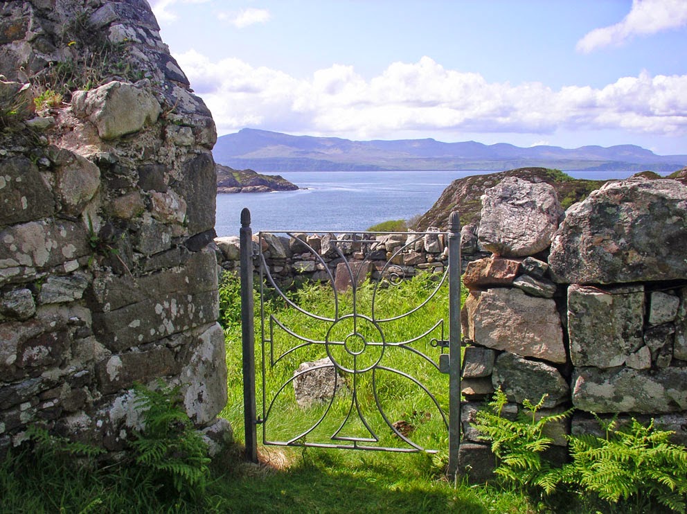
Beautiful chi-rho-cross on the gate to the burial ground
From An Teampull I followed the coast east to the tidal crossing to Eilean Garbh. The tide was out, and so I was able to cross to the base of the island. But I could not get up onto the top of the island because the mini-cliff that would have to be climbed proved too challenging. I could see a muddy, near vertical way up that was covered in deer tracks. But I'm not a deer, and being alone I decided not to risk the climb. I'd been told there might be some ruins on the island, but they would have to wait for another time.

West side of the crossing to Eilean Garbh
East side of the crossing to Eilean Garbh
On the exposed crossing
I started the trip back to Dry Harbour by returning to the hillside above An Teampull, where I sat for a while to enjoy one of my favourite places on Rona, with its amazing view of the chapel, Eilean Tighe, and Kyles Rona.

An Teampull

Thursday, April 23, 2015

South Rona - The Whisky Isle

Port a' Chreadh, on the east coast of South Rona, was once the site of a whisky still. The name, Port a' Chreadh, means Port of Clay, which is usually assumed to mean Port of the Clay Pot. Few visitors to Rona make their way to Port a' Chreadh; for although it is only a quarter kilometre off the track to Dry Harbour, it is a hard, bush- and bog-whacking walk down through dense vegetation. It took me the better part of an hour to struggle through the forest and bog to reach the site.

Two whisky sites - South Rona
The walk down to Port a' Chreadh was worth it. Once I reached the shore I came to a beautiful small peninsula with landing places on its north and south sides. Whichever way the wind was blowing, you'd have an option to get ashore, or set out to sea with a load of hooch.

North Landing - Port a' Chreadh
South Landing - Port a' Chreadh
Somewhere here was 'The House of the Black Pot', where the whisky was made. At Port a' Chreadh I did not find any ruins the size of a house, but I did find a small rectangular ruin, its stones covered in a thick cloak of moss. Perhaps the still was here.

Ruin of small square building at Port a' Chreadh - could this have been the site of the whisky still?
Alasdair Alpin Macgregor, in his Over the Sea to Skye, talks a bit about the whisky distilling and smuggling around Rona, and you can read an excerpt from it here. (It was this story that made me want to visit Port a' Chreadh.) There were several distilling sites on Rona, and another was at Acairseid Fhalaich (the Hidden Harbour), four km to the north. These days no whisky is made on Rona (that I know of...), but at the same link above you can read about a special bottling of Edradour Whisky that commemorates Rona's history of whisky making.

I did see something strange at Port a' Chreadh: a thick electrical cable that came ashore and disappeared under the turf to the west. It appeared to head up the treed glen to Meal Acairsaid, the highest point on Rona, and made me wonder if it was an old power cable to a beacon on the hill. Any one out there know what it was?

Old cable from the mainland to Rona
Next time I'm on Rona I hope to get up north to Acairseid Fhalaich - the hidden harbour - to search for the site of the other still. Maybe the MOD (now Qinetiq) guys, whose base is only 500 feet away, are carrying on the tradition.

Tuesday, April 21, 2015

High Atop Vatersay

Here are some views that await those who take the time to ascend Heishaval Mor, the highest point on Vatersay.

Atlantic breakers rolling into the West Bay - Sandray in the distance
A calm East Bay - the old schoolhouse (now self catering) at lower left
A late afternoon view to Castlebay
The Vatersay Causeway
The next photo was a poor attempt to duplicate Robert Adam's photo of the same scene in 1922. (See this Univ. of St Andrews page - photo item # RMA-H-1061.)

Snowy east slopes of Heisibhal Mor
The last view is of Muldonaich, an island I hope to visit someday.

Looking east to Muldonaich

Sunday, April 19, 2015

The Isle of Mary Rose

J M Barrie wrote the play Mary Rose between 1912 and 1920. He conceived the idea for the play—which is based on Celtic legends of faeries and Tir nan-Og, the Land of Everlasting Youth—while staying at Amhuinnsuidhe Castle on the shore of West Loch Tarbert. The story concerns the two strange disappearances of Mary Rose from The Island that Likes to be Visited. At age eleven Mary is left on this small island while her father is fishing. When he returns she’s nowhere to be found. Several weeks later she reappears with absolutely no memory of where she’s been, and no sense that any time has passed. Later in the story we learn a similar event had happened before, when a two year old boy had disappeared from the island; a boy who had yet to be found.

An Island in Loch Voshimid
Eleven years later Mary Rose visits the Hebrides with her husband and two-year-old son, a son supposedly born while her husband was away. The island calls again ‘but no one can hear it but those for whom it is meant.’ It is meant for her, and this time she disappears for twenty-five years. When she returns from that long absence we find she has not aged, and it seems to her as if only an hour has passed.

Loch Bhoisimid lies in the Harris interior, four miles north of Amhuinnsuidhe. The tradition on Harris is that an island in this loch had been the inspiration for Barrie’s mystical island. In the play the island has two trees, a pond, and a small hill—perhaps one of the faerie knolls of Celtic legend? It is also said to be an island that comes and goes, where again we have an item from Celtic mythology, the floating island. At the end of the story, a final bit of legend appears, when a piece of iron (her son's knife) holds open the trap to the faerie world.

I visited Loch Bhoisimid in 1998, on a long walk from Bogha Glas to Miabhaig via Kinlochresort (see Book 2, chapter 17). The water level was low at Bhoisimid, and I was able to cross stepping stones to a small island that seemed to like being visited (see photo below). I'd like to think it was the island that inspired Barrie, but no one really knows what island he had in mind, or if indeed it was any specific island.


Alfred Hitchcock dearly wanted to make a movie version of Mary Rose, but he could never convince a studio to do it. Even so, he commissioned a screen play, which you can read here. And listen to this link for an hour-long BBC radio play performed in 1991. 

Next time you are on Harris be sure to read the play and then make the walk to Bhoisimid. Better yet, take the play with you and read it on a little island that likes to be visited. Just don't fall asleep.

Friday, April 17, 2015

The Worm Hole

It was a miserably wet day when I hiked out to see the Worm Hole; an odd, rectangular pit, on a giant shelf of stone below the cliffs of Inis Mor, the largest of the Aran Islands. But the walk was worth it, as the hole is quite a sight, especially on a stormy day. It is connected to the sea by a natural tunnel, which can cause the water in the pit to churn on its own, which led to the legend that it was the abode of a giant worm. 

The Worm Hole
A few days ago a tourist was standing on the spot where I took this photo of the worm hole. She was washed off her precarious perch by a giant wave, and landed on the rocks below (a helicopter came to her rescue). Some of the reports imply she fell into the worm hole itself, but the video does not clearly show where she landed. See this Irish News page for a video of the incident.

Wednesday, April 15, 2015

The Carved Stones of Eigg - 3

Eigg's most interesting carved stone is an 8th (or 9th) century example of recycling. The cross, which was found at Kildonnan in two pieces, has been put back together with concrete. One side is carved with an elaborate ringed cross, topped with the letters 'IHU  XPI', a Latin abbreviation for Jesus Christ (Oh Jesu, of Christ). But it is the other, and older side of the stone, that is really interesting. It depicts a mounted hunter with two dogs chasing what appears to be a lion, a boar and a deer - quite an assortment of animals. The scene is carved such that the stone was intended to be oriented the long way (as shown in the second photo). Perhaps the stone was a shrine to an early ruler of Eigg, which was later reused to make an ornate cross.


Sadly, as you can see in the photos, the side with the hunting scene is severely eroded. You can see a better image of it on this RCAHMS page. You can also see it on the Eigg History Society website (they use the hunter depicted on the left side of the stone for their logo). If this stone interests you, a complete description can be found in this article in Medieval Archaeology.

Monday, April 13, 2015

The Carved Stones of Eigg - 2

You will find several interesting carved stones in the ruin of Kildonnan church. One is a beautiful 8th century cross stone; four equal arms with barred ends contained within a recessed circle.

The cross and the Sheela (or is she an angel?)
Behind the cross, and mounted in her own little house on the church wall, is the Kildonnan figure. As her hands are posed across her lap, some think she may be a sheela-na-gig. But others call her an angel, for what appear to be large wings on each side of her head. But the 'wings' could be depictions of either large ears, or a good head of hair. See the 'Kildonan' page on sheilanagig.org for more on this mysterious figure.

The Kildonnan figure - is she a Sheela?
On the side of the church is the 16th century tomb of the piper Raghnall Mac Ailein Oig, which is marked by an elaborately carved Clanranald shield (see photo below). I have seen similar carved shields at Kilmory Church in Arisaig, and the Kildonnan museum in South Uist. The Uist stone has an interesting history. In 1990 it was stolen from its location in Howmore. Then, in 1995, when an apartment in London was being cleaned out after its tenant died, the stone was found. In 1999 it was returned to S. Uist, where it is now safely held at the museum. (See this link for a photo of the Howmore stone.) Next time we'll visit the Kildonnan cross-shrine; the most intriguing carved stone on Eigg.

Clanranald Shield at Kildonnan

Saturday, April 11, 2015

The Carved Stones of Eigg - 1

There are some remarkable carved stones on the island of Eigg. Most are thought to have originated in Kildonnan, a monastery founded by St Donnan in the 7th century. The only building on the site today is a church that dates to the 16th century, but remnants of the original monastery have been uncovered under the turf between the shore and the church.

Mounted on a pedestal in a field next to the roofless church is an ornately carved shaft of a cross. The cross, of the Iona type, is thought to date to the late 14th century, and is carved from Loch Sween schist, so perhaps it was carved on the mainland near Kilmory Knap, and then shipped to Eigg. 

The cross shaft at Kildonnan
As you can see in the photo, at some point in the last 500 years the cross must have fallen, as the cross-head has broken off. Unfortunately it's gone missing; either lost or taken by thieves. Today you will find an unrelated cross-head propped up against the cross-pedestal. I read somewhere that it was intended as a replacement head, and is a copy of the top of Prior Colin's Cross on Oronsay.

Eigg cross shaft with the stand-in head on the ground
The crucifixion scene on the face of the stand-in head has been heavily worn by the elements and is barely discernible. However, the beautiful carving on the reverse side is still in good shape.

Reverse side of the Eigg stand-in
The cross slab also graces the cover of the 1927 edition of Kenneth Macleod's The Road to the Isles. (Macleod was born on Eigg.)


There is not much information on the headless shaft. It's not mentioned in Romilly Allen's Early Christian Monuments of Scotland, and the only thing TS Muir has to say of it in his Ecclesiological Notes on the Islands of Scotland is: ...within it (the chapel) is a slab covered with folaige. That description was from 1856, so it was at some point after that that the slab was erected on a pedestal outside the church. The next photo is a side-by-side comparison of the Oronsay cross and the replacement head. They do look similar. See this RCAHMS page for more on Kildonnan, and be sure to see this Eigg History Society page for a information on excavation work that has uncovered some of the old monastery, and includes a drawing of what it may have looked like.

Eigg stand-in (left) and the Oronsay Cross (right)

Sunday, April 5, 2015

Loch Enoch

One of my favourite Scottish books is J McBain's The Merrick and the Neighbouring Hills (1929). His description of hikes in the interior of Galloway are fascinating; especially his visit to an unnamed island in the most remote loch in the country: Loch Enoch.

This unnamed island has its own little loch, and some say that the name 'Enoch' comes from 'Loch-in-loch'. Another, and more likely possibility, is that it is named after Teneu (St Enoch), the mother of St Mungo of Glasgow.

Arriving at Loch Enoch
I first wanted to visit this area after reading SR Crocket's novel The Raiders, as many scenes in the book take place in this remote country. But I never did anything about it until I after I read McBain's book. I was planning a stay in Girvan, in order to get out to Ailsa Craig, and I thought that a hike to Loch Enoch would make for a great day out if my plans to get to Ailsa were foiled (see chapter 2 of book 1). I did manage to do both: visit Ailsa and Loch Enoch, but I had to settle for seeing Enoch's little island from the shore. Most visitors will have to settle for the same view, because it is so remote that, as far as I know, no boat has ever been brought to the loch.

There are two usual routes to the loch; one is a six-mile trek from the south end of Loch Doon, the other (and the one I took) is a five-mile hike north from Loch Trool. From the Bruce Monument at Loch Trool I hiked a mile north to Culsharg bothy.

Culsharg Bothy
From Culsharg I followed the Buchan Burn north through forestry plantations and under the Rig of Loch Enoch. After bashing through some thick heather I reached the southwest corner of Loch Enoch. Rising across the loch was the brown hump of Mullwharchar, also know as Star Hill. 

Mullwharchar rises above the north shore of Enoch - in the foreground is the island
I had lunch on a small sandy beach looking over to the island. Oh how I wanted to set foot on it, but I was not in the mood for a cold swim. J M'Bain in The Merrick and the Neighbouring Hills describes how he got to the island by visiting it in the winter when the loch was frozen, and he was able to walk to the island. Maybe I'll come back in the winter sometime and try to follow in his icy footsteps.

The isle of Enoch - its own small loch can be seen to the right
From Loch Enoch I climbed Dungeon Hill and then returned to Loch Trool via the Murder Hole of Loch Neldricken. It was a great day on the hills, one I will remember forever.