Saturday, June 29, 2013

Ardveg

We made it to the Ardveg today. I will write more when I get home in a few days as I hate typing on this iPod. Here are a couple of photos from what was a memorable day.


Saturday, June 22, 2013

Off to Ardveg

I will be off-line for two weeks. I am spending some time on Scalpay, Harris and Lewis. On June 29 I hope to attend an Islands Book Trust event at the Uig Community Centre, where they are launching a book called An Trusadh - Memories of Crofting in the Ardveg, by John Macdonald. If the weather is obliging it will be followed by a boat trip to remote Ardveg, where I camped a decade ago (book 2, chapter 21). I also plan to hike around the hinterlands of Lewis and Harris in search of beehive cells, and to walk the old path to Renigidal and Molinginish. I hope to have some interesting photos to share when I return.
Ardveg - Photo by A A MacGregor

Thursday, June 20, 2013

Journey to Tiree 5

After visiting the golf ball radar that sits on Carnan Mor, the highest point of Tiree, I went in search of a quieter summit. I found one here at the west end of the island on Beinn Ceann a' Mhara. Nearby is the site of the fort of Dun nan Gall, and the hill in the distance is Beinn Hough.


It is time to leave Tiree, for now, anyway. We're returning to Glasgow aboard Twin Otter G-BVVK. She's my favourite little airplane, having taken me to both Tiree and Barra, and one time delivering my lost luggage after I'd been on Barra for three days without it.

Wednesday, June 19, 2013

Journey to Tiree 4

Here are a couple of random photos from a wander around Tiree on a wet autumn afternoon. I used the phone box in the first photo to shelter from a brief rain storm. But there was no such shelter when another blew through when I was sitting on the top of the island (second photo). But the big golf ball, an ATC radar, provided some shelter.


Tuesday, June 18, 2013

Journey to Tiree 3

On the coast of Tiree due north of Kirkipol lies the ruined broch of Dun Mor Vaul. Its circular foundation, thirty-five feet in diameter, stands six feet tall, and when originally built it had been about thirty feet high. On the inside of the wall sit the base of the stairs that once wound all the way to the top of the tower (second photo). Many features of the defensive nature of the building are still evident: holes for the bar that held the door closed, and a guard chamber next to the entrance.


A mile SW of the broch you will find Clach a Choire, the Kettle Stone, better known as the Ringing Stone When I tapped on it with a beach pebble it sang out a high pitched metallic chime. The Tiree stone is not alone, as there are other Ringing Stones in Scotland, for example this one in AberdeenshireThe Tiree stone has over 50 of the mysterious cup markings that no one knows the meaning of, but there are some fascinating theories. My favorite involves the cup-carver's intentionally directing earth energies. If you want to read more on this there is an interesting book on the subject called Ley Lines and Earth Energies.

Monday, June 17, 2013

Journey to Tiree 2

This photo shows a Twin Otter landing on the Reef, Tiree's airfield. For a fascinating description of the airfield's (and some of Tiree's) history, there is a wonderful book recently published by the Islands Book trust called Tiree - War among the Barley and Brine.

Twin Otter landing at the Reef
On my visit to Tiree I stayed at the Tiree Lodge Hotel, which you can see to the left in the next photo. The hotel is located in a magnificent spot. In front of it lies Gott Bay and the two mile long strand of Traigh Mhor, and behind it are the ruined churches of Kirkipol.

On the way to Gott Bay
Kirkipol Chapel

Tomorrow we'll cross over to the north coast of Tiree to see the broch of Dun Mor Vaul and the Ringing Stone.

Sunday, June 16, 2013

Journey to Tiree 1

Yesterday's photo from Erraid reminded me of this picture of the island that I took from the window of a Twin Otter on a flight from Glasgow to Tiree. The loch with the small island in the foreground is Mull's Loch Poit na h-I. The second photo is an even closer look at Erraid I was fortunate to get on the return flight. Tomorrow we'll land on Tiree and tour the island.


Saturday, June 15, 2013

House Boat

Is it a House Boat or a Boat House? I came across this example of recycling on a gray June day while exploring the island of Erraid. On a rainy night the pitter-patter of rain on metal might keep you awake. In case a tsunami hits the occupants would be well prepared.


Friday, June 14, 2013

Midges

Reading Paul Camilli's Rassay blog yesterday I learned of the Midge Forecast. It reminded me of a night I spent in Glen Coradail of South Uist last June. The bugs came out in force around 7pm and I had to retreat to the tent well before sunset. I will be hiking around Harris, Scalpay and Lewis in the coming weeks, so I hope the 1 out of 5 rating the forecast currently has for that area holds.

Shields up in Glen Coradail

Thursday, June 13, 2013

Flannan Isles 6

We will say goodbye to the Flannans from the top of the island. Eilean Mor has two summits: the eastern one with the lighthouse, and the west summit with its cairn and puffins, which is where the fellow in the photo is heading.  

On the way to the west summit
View from the west summit
This hefty cairn marks the top of the west summit. The next landfall is St Kilda, some 50 miles away, then Rockall, another 200 miles out. A beer was called for to celebrate getting onto the island - Slainte Mhor!

Happy Hour on the Flannans

Wednesday, June 12, 2013

Flannan Isles 5

It is time to head down to the infamous West Landing. The walk down the crumbling stairways to see it is an experience to remember, especially if the sea is churning.


This is the upper platform. It is here they think a blow-back of surf from a depression in the cliff (which you can see to the right) swept the men away. 

Upper Platform - West Landing
Getting to the lower landing from above can be tricky. The stairway down to it has washed away, and when I was there the slimy, black-stone bedrock was too slick to cross, so I had to settle for this view from above. Tomorrow we'll leave this wild spot and climb to the top of the island to take in the view.

Lower platform - West Landing

Tuesday, June 11, 2013

Flannan Isles 4

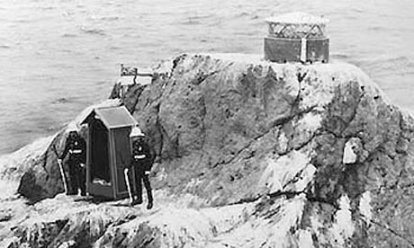
Flannan light, built by the Stevensons, became active in December of 1899. Three keepers were stationed on the island, and in December of 1900 they all vanished. When the relief crew arrived at the east landing no one was there to meet them. They went up to the lighthouse and found the outside doors closed, but an interior kitchen door ajar. When they searched the island they found signs of severe storm damage at the west landing, but no sign of the keepers. The final lines of Wilfrid Wilson Gibson’s poem The Flannan Isles describe the moment when the relief keeper, and two boatmen, finally gave up the search for the missing men.
 
Three men alive on Flannan Isle,
Who thought on three men dead.
       
If you want to read the full text of the poem you can find it here. Other deaths have occurred on the island. One man fell or jumped from the tower, and several drowned at one of the landings: sinister events for such a small island. Tomorrow we will head down to the storm battered West Landing.

Charing Cross - where the tram tracks from the east and west landings meet

Monday, June 10, 2013

Flannan Isles 3

We are now ashore on Eilean Mor of the Flannans. Here's a view of the tram track you climb to reach the top of the island from the East Landing.


Once up the track you come to the Taigh Beannachadh, the blessing house, a small chapel that may have once been a beehive cell.


Before heading up to the lighthouse I entered the chapel. It was being used to store building material, and I sat down on a bag of stone to enjoy a few moments of quiet before heading on to the lighthouse, which we will see tommorow.

Thursday, June 6, 2013

Flannan Isles 2

This small bay between Eilean Taigh and Eilean Mor is the only anchorage at the Flannans. Here you can see the east landing stage at the base of the cliffs on Eilean Mor. The sea must be calm to get on to it, and people have been injured trying to land here. Although the odds are against a landing, I was lucky. On my first visit we managed to land, but on a second visit, a few years later, a heavy swell precluded any attempt to get ashore, so we had to head out to St Kilda (a great consolation prize).

Once ashore it is a short climb up the old tram-track to the top of the island. In the 1970s the track was torn out, and in its place a vehicle called the gnat hauled supplies up to the lighthouse. You can see a photo of the gnat in action here. Next Monday we'll get up top and have a look around.


Wednesday, June 5, 2013

Flannan Isles 1

How about we head to the Flannan Isles for a few days?  They are also known as The Seven Hunters, and this is the view as you approach from the east. In the photo you can just make out the infamous lighthouse on Eilean Mor, the largest of the isles. Tomorrow we'll drop anchor below the lighthouse and attempt a landing.


Tuesday, June 4, 2013

Loch of the Amazons

This is a view of the Sgurr of Eigg that you don't see too often. It highlights how the tip of the Sgurr is a mini Devil's Tower, and not one long sloping ridge as it appears from the east. From this angle the Sgurr looks like a giant serpent slithering across the island.

The photo was taken from above the northern shore of Loch nam Ban Mora, the loch of the great (or big) woman. The little island in the loch was a small dun. MEM Donaldson wrote, in her amazing tome, Wanderings in the Western Highlands and Islands, of the legend that you could reach the island by stepping stones. From the shore there were no signs of stepping stones, or a causeway of any sorts, and so I climbed a bit to get a better look. The water was crystal clear, and from this high vantage point it was clear that there were no stepping stones. So your only option to see the fort up close is a cold swim. I chose to stay dry and enjoy the view from here.

Monday, June 3, 2013

Rockall

No, I have not been to Rockall, but it is on the list. One fellow who has is Nick Hancock. Unfortunately his attempt to set a record 60 day occupation of Rockall this year was just thwarted by heavy seas. See this link for an amazing video of the climb to the top of Rockall that he made in 2012.

On guard atop Rockall in 1971: Purported MOD photo - perhaps published on April 1, 1971

Sunday, June 2, 2013

The Beacon Cairn of Killegray

The summit of Killegray has a unique cairn. As you can see there is a large opening at the base, and another higher up. I was told that this was so a fire could be lit inside. It was either a navigation beacon...or maybe a barbecue...


As I said yesterday, the owners of Killegray are not too keen on visitors, especially beer-swilling island-baggers like the fellow in the next picture.

Saturday, June 1, 2013

Killegray House

It's a short hop from Ensay to Killegray, about a quarter mile. But it took me eight years to make that hop. The owners were not keen on visitors back then (and today), so I was lucky that no one was home on the day I visited. The original house dates to the 18th century, and a modern addition (to the left) was added in the 20th century.  Atop the island sits the beacon cairn, which we'll visit tomorrow.