Tuesday, July 29, 2014

An Leac Bhàn - Berneray

One of my most cherished old books on the Scottish islands is Alasdair Alpin MacGregor's Searching the Hebrides with a Camera (1933). This wonderful book inspired me to find ways to set foot on remote isles such as the Monachs, Ensay, Pabbay and Killigray. It also sent me to the northern tip of North Uist, opposite Berneray, to search for a certain boulder that lies at An Leac Bhàn.

An Leac Bhàn (the white slab) had been the traditional ferry-point to Berneray, and a large boulder there marked the spot where, if you made yourself visible, the ferryman on Berneray would come fetch you. The stone is pictured in Searching the Hebrides with a Camera, and MacGregor writes about resting on it while waiting for the ferryman to come over:

Down through the silverweed and the iris-flags I linger to the foreshore at the Leac Bhàn, and seat myself upon a boulder that has known me for some years now. This boulder and I seem to recognize each other. It invites my weight with an intimacy convincing me that even the things men describe as inanimate object may have personality.

MacGregor's photo of An Leac Bhan (c. 1930s) - boulder at far right
During the spring of 1997 I found and sat upon MacGregor’s boulder. If I’d looked a year later I’d have been out of luck, for it became part of the Berneray causeway in 1998, buried under tons of quarried stone, never to be seen again. When I sat on it (last photo), waiting for the Berneray ferry the causeway would soon replace, the memories captured in my mind from reading MacGregor’s book came alive, and I was taken back sixty years to that day of wandering he so well described, a day when he sat at An Leac Bhàn awaiting the ferryman.

Looking towards Berneray from An Leac Bhan (1997)
Berneray ferry approaching An Leac Bhan (1997)
Seated on MacGregor's boulder - now buried under the causeway

Sunday, July 27, 2014

The Berneray King-Stone

There are several inauguration stones in Scotland. The most famous is the Stone of Scone; stolen by Edward I in 1296, and placed under the Coronation Chair in Westminster Abbey until it was returned to Scotland in 1996. Although there are many who believe the stone Edward took was a fake, and that the true stone is still hidden in the Hebrides.

The early rulers of Argyll and the Islands had their own inauguration stones, with a footprint carved in them where the King-To-Be would place his foot. Dunadd is the best known of these, and if you make the easy climb to the top of the hill you will find a footprint. But if you put your foot in it you will not be following in the footstep's of kings; for the true stone-footprint lies under the concrete replica that caps the hill, lifted in place by a helicopter.

I've only heard of two inauguration stones in the Hebrides, both of them associated with the Lords of the Isles. The best known was on an island in Loch Finlaggan (Islay); but you can not put your foot on it these days, as at some point in time it was destroyed. The other Lord of the Isles' stone is on Berneray (Sound of Harris). The Berneray stone is near Cladh Maolruibhe (the burial ground of St Mealrubha), which lies atop a hill called Beinn a' Chlaidh (see this RCAHMS link for more). The site is easy to find as it has an eight-foot-tall standing stone.

Berneray Standing Stone - Pabbay in the distance

The Berneray Stone
One-hundred meters southwest of Cladh Maolruibhe is a jumble of stones that may have once been a large cairn. In amongst them lies a large slab with what I thought at the time had the form of a footprint chiseled out on top. It was not much of a footprint, appearing to have flaked away over the centuries. My boot fit, sort of, and so I celebrated my inauguration with a can of beer. 

Update April 27, 2021: I learned in 2021, many years after the visit described above, that the actual footprint stone lies  at NF 9116 8059, some 90 meters east of the stone I found - see this link. So I can no longer clam to be Lord of the Isles.
The Footprint Stone - or so I thought
A close fit - only off by 90 metres

Thursday, July 24, 2014

The Beehive Cells of Both an Aird

I first read about the beehive cells at Both an Aird in DDC Pochin Mould's amazing book West Over Sea. They are probably the most remote beehive cells on Lewis - a mile and a half SE of Hamanavay - so unless you can get someone to take you by boat to Hamanavay, getting to Both an Aird requires a hard 12-mile hike from Uig. For most people (including me), a 24 mile round trip in one day is a bit much, especially across this tough terrain. And so I decided to visit the beehives as part of an overnight excursion; a one way walk from Uig to Morsgail. 

Once I crossed the footbridge over the Hamanavay River I made my way up to the ruin of the mill below Loch Grunavat. From there I followed a series of derelict telegraph poles along the east shore of the loch. I followed the poles up the narrow glen of the Feadan Grunavat (the little Grunavat stream), and once Loch Bodavat came into view I turned south to climb the heather-clad slopes of Cleit nam Bothan Aird. Aside from being on the side of the hill, I was not sure where the beehives were. I circled a small knoll atop the northern side of the hill, but there were no beehives to be seen. I then circled a smaller knoll to the south, and was about to give up the search, when I saw them.

Looking south to the Bothan Aird Beehives
The two cells - the one on the right has collapsed
Bothan Aird is actually a pair of side-by-side cells. One of them has almost completely collapsed (to the right in the previous photo), but the second is intact. I'd planned to spend the night in the intact cell, but it was a bit gloomy, so I decided to carry on another four miles to spend the night atop Beinn Isobhal (see February 23, 2013 post), and then the next day I followed the postman's stones to Morsgail. 

Below are two close-up photos of the intact cell at Both an Aird. See plate 13 of this Society of Antiquaries report for a detailed drawing of the beehives as they were in 1857.


Monday, July 21, 2014

John Rae

I am ending my posts on Orkney with a visit to one of my heroes.

In the 1990s and 2000s, I worked with a brilliant engineer named Hans Muller, who has since passed away.  Hans spent a lot of time hiking in the Canadian North, and he told me about one of his heroes, the Scotsman John Rae. Hans loaned me a wonderful book about Rae called Fatal Passage (by Ken McGoogan).  After I read it Rae became one of my heroes, too.

Rae, born in Orkney in 1813, was one of the most successful of the Arctic explorers and, among many accomplishments, found the final link in the Northwest Passage. Much of his success was due to his use of the clothing and diet of the native people. Rae died in 1893, and is buried in the cemetery of St Magnus Cathedral in Kirkwall. Inside the church there is a large memorial to Rae (photo below) that shows him taking a snooze during one of his expeditions, rifle at his side. And so when I was in Kirkwall the first thing I did was go to the cathedral to pay my respects.

For a synopsis of Rae's amazing life see this Orkneyjar link.


And so ends my Orkney journey for 2014. In two weeks I managed to set foot on eight of the islands. It was only a small 'taste of Orkney', as there are about 25 islands in the group that I want to see. So I plan to return.

Saturday, July 19, 2014

Quoyness Chambered Cairn - Sanday

Most visitors to Orkney pay a visit to the great chambered cairn of Maes Howe. It is an amazing thing to see. But due to the large number of visitors you have to book ahead to see it; and when you get there your visit is highly regimented. A tour guide herds everyone inside, and then proceeds to give an informative talk on the tomb. No photos are allowed, and once the talk is over everyone is herded back out. Fortunately there are several other spectacular chambered cairns on Orkney that are accessible to travelers who, like me, relish seeing sites like this without the crowds.

I previously described a visit to the massive 'long' chambered cairn on Holm of Papa (see July 6 post). Another impressive cairn I visited last month was Quoyness Chambered Cairn on Sanday.


Quoyness is a smaller version of Maes Howe. As with Maes Howe, the cairn dates to around 3000 BC, and you enter it by crawling along a narrow passageway.


After crawling through the 30-foot-long passage I came to the central chamber. Even standing up I could not touch the roof, as it is 12 feet high.


There are six small side chambers, and I crawled into one to take a close look. One of my disappointments when I saw Maes Howe was that they do not allow visitors to enter the side chambers.


Spending some time alone in this ancient sacred place was a privilege. See this Orkneyjar link for more information on the Quoyness cairn. After seeing it I spent an hour exploring the Elsness Peninsula and the nearby white-sand beach of Sty Wick (the last two photos).

Next time I'll end my Orkney posts with a visit to another, and much more recent tomb. The 1893 grave of one of my heroes: the Orcadian John Rae.


Tuesday, July 15, 2014

Egilsay of St Magnus

I was hoping to get ashore on Egilsay last month to get some good photos of the round tower church of St Magnus. Magnus was martyred on Egilsay around the year 1117. See this Orkneyjar link for the complete story of St Magnus.

I had visited Egilsay once before, back in 1990. But unfortunately (for me) the tower was encased in scaffolding, which did not make for good photos. (See the Nov 21, 2013 post.) So last month I was looking forward to returning to get better photos, but it was not to be.


Church of St Magnus - 1990
On June 20 we left the Bay of Ham (Rousay), where we'd anchored the previous night. Everyone was looking forward to seeing Egilsay. We slowly approached the pier on its west side, hoping to tie up, or anchor nearby. But a 12 knot westerly was blowing. With no sign of it abating, all thoughts of getting ashore had to be abandoned. We were disappointed, but that's how it goes when you're afloat, you have to go with the flow. And so we turned north to set our sights on Westray. Below are photos of the round tower that I took from the boat. I hope to return someday to try again.

St Magnus Church - 2014

Thursday, July 10, 2014

Chapel of St Triduana - Papa Westray

Old pilgrimage sites have always interested me. One of the most interesting is the Chapel of St Triduana (aka St Tredwell) on the island of Papa Westray. So when I was set ashore on Papa Westray a couple weeks ago, the first thing I set out to see was the chapel ruin. 

From the Bay of Moclett at the south end of the island, I walked a mile up the east coast to the Bay of Burland. From there I turned west to cross a large, grassy field, to reach the Loch of St Tredwell. 

The Chapel of St Triduana on its once fortified islet
The chapel lies on a mound in the loch that was once an island. There was a broch tower there some 2000 years ago, and the chapel was built in the 12th century from stones taken from the broch. A narrow neck of land now connects the mound to the shore, and after walking across it I found the chapel ruin half obscured under a thick growth of grass and nettles. 

A pilgrimage to the chapel, along with walking around the loch and washing your eyes in its water, were said to cure blindness. Here's an extract of the history of St Triduana from the Catholic Online page:

According to the 16th-century Aberdeen Breviary, Triduana was born in the Greek city of Colosse, and travelled from Constantinople with Saint Rule, who brought the bones of Saint Andrew to Scotland in the 4th century AD. A pious woman, she settled at Rescobie near Forfar in Angus, but her beauty attracted the attentions of a King of the Picts named Nectan. To stall these unwanted attentions, Triduana tore out her own eyes and gave them to Nechtan. Afterwards, she was associated with curing eye disorders. She spent her later years in Restalrig, Lothian, and healed the blind who came to her. She was buried at Restalrig when she died.

As described on the Orkneyjar website, the chapel was one of Orkney's most visited pilgrimage sites for centuries, and I wonder how many desperate people over the years managed to make their way to this remote spot. These days I don't think many people visit, as I had it all to myself. My mother would be undergoing cataract surgery in a couple of weeks, and as I sat in the chapel ruin I prayed to St Triduana that it go well. It did.

What's left of the chapel of St Triduana

Sunday, July 6, 2014

Holm of Papa

During my Orkney cruise we landed on Papa Westray. Once ashore I set out to find the Chapel of St Tredwall, and as I walked up the east coast of the island I noticed a tiny island just offshore. On it stood a large mound, capped with what appeared to be a standing stone.

Holm of Papa seen from Papa Westray
I looked at the map and discovered the island was Holm of Papa, and on it are three chambered cairns. The large one that I could see was marked on the map with the 'Historic Scotland' logo; meaning it was a significant site. But, strangely, there was no 'Standing Stone' marked as well, although there certainly appeared to be one, and a big one at that.

Back on the boat I looked up Holm of Papa in the Island Bible (Hamish Haswell-Smith's The Scottish Islands). In it he mentions that the cairn is of the Maeshowe type, but much older, and possibly connected to the settlement at Knap of Howar on Papa Westray. The cairn is huge, with 12 side chambers, and carved on some of the stones inside are strange eyebrow and cup mark carvings. Later I would learn that the top of the cairn was rebuilt, and a cement roof put in place in 1929. For photos of what it looked like before restoration see this RCAHMS page. The cairn is also known as Diss o' the Holm. (See this link - though I have no idea what 'Diss' means.)

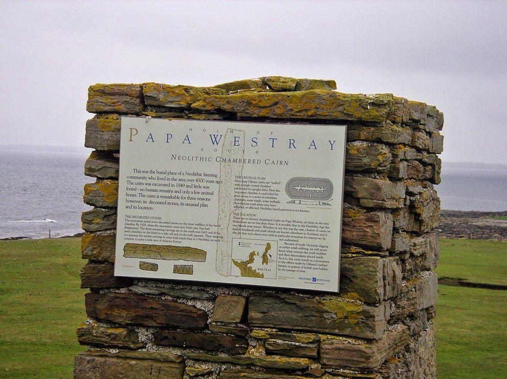
I had to see this amazing thing first hand, so I asked if we could pay a visit to Holm of Papa after we set sail from Papa Westray. Fortunately, on the following day the sea was calm, and so we were able to land. On close inspection what had appeared from a distance to be a standing stone was actually a large square cairn, and on it was the Historic Scotland reader-board describing the tomb below.


Tomb diagram on the plaque
The original entrance to the tomb was blocked up, but atop the mound a steel hatch opened up to reveal a ladder. It was time to descend into the dark tomb.

Original entrance - now closed off
Down we go
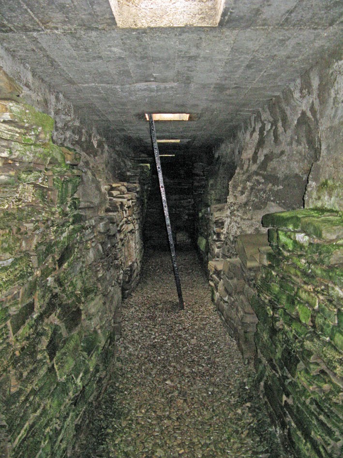
Once you get into the tomb it is not so dark, as two thick skylights have been inserted in the roof. 

Central Aisle
The ground was covered with a layer of wet and muddy gravel, and we got quite dirty crawling through the low tunnels that give access to the end chambers (next photo). It was only after we'd crawled through them that we discovered a set of 'crawling mats' stored on a dark side ledge.

The low opening that leads to one of the end-chambers
Inside one end chamber we found the strange eyebrow and cup carvings.

The carvings
We left the tomb via the ladder, closed the hatch securely, and then went for a short wander around the tiny island. The other cairns on the island were in sad shape, but the layout of the northernmost one was just discernible.

The North Cairn
Just before we left, one of the two little airplanes that do the Orkney inter-island flights buzzed overhead, having just taken off from Papa Westray. I'd seen it the day before, and the sight of it strengthened my resolve to make the world's shortest flight - which I'd do four days later (see June 26 post).


Friday, July 4, 2014

Noup Head and the Gentlemen's Cave

Can you remember the exact date you first wanted to visit a specific island? I do, for it was on December 30, 1990, that I read something that made me want to visit Westray of the Orkney Islands. On that date my wife and I were in Vancouver BC visiting its many bookshops, as they always have a better selection of old Scottish books than the stores in Seattle. One of the books we bought that day was T. Ratcliffe Barnett's The Road to Rannoch and the Summer Isles (1924); which I devoured as soon as we returned to the hotel.

The tales in this wonderful book inspired several walks I would eventually make in the Hebrides. But one of the chapters stood out above the rest, as it described an airy walk to a hidden cave in Orkney. The chapter was called The Bad Step: A Jacobite Hidie Hole in the Orkneys. It described how William Balfour of Trenabie (in the northeast corner of Westray), supported the Jacobites in the '45. And as Barnett says in his book, after the loss in the '45 "Balfour and his friends '...were compelled to skulk in caves and dens of the earth'. Some of these hideouts became known as 'Gentlemen's Caves', and the most remote, and hard to reach of these was below the cliffs of Noup Head, where Balfour and 11 companions spent an entire winter.

In his book, Barnett describes searching in vain for the route down the 200-foot-high cliffs to the cave. And then how he found a local man that guided him there along a series of ledges. The route involved crossing the 'Bad Step', where you have to cross a gap in a ledge, where a misstep meant plunging 80-feet to the sea.

After reading this story (24 years ago) I decided I wanted to go there someday. And so when I found myself on Westray two weeks ago I decided to look for the cave. From Pierowall I hiked the four miles to Noup Head Lighthouse. It was a sunny, hot day, and the views from the lighthouse were stunning.

Noup Head Lighthouse
From the lighthouse I followed the cliff-tops to the south. It was a wonderful walk, the cliffs covered with nesting seabirds, including hundreds of gannets.


I had the grid coordinates for the cave (HY 398 486), and after walking for a mile I reached the spot. But, as had happened to Barnett, I could not find a route to the cave. You definitely need a local to show you the way. I was disappointed, but I also realized, while looking down the shear cliff, that I would probably not have the nerve to follow the route even if I'd found it. When I first read about the airy walk to the cave I was in my 30s, and would have had no such second thoughts. But now, nearly 25 years older, I was much more cautious. I decided that standing on the cliff above the cave would have to suffice, and I would not seek a local to show me the way. The decision was made easier by the fact that in the coming days I would be sailing by here, and so I would be able to get a close look at the cave from the sea.

Two days later the ship Zuza left Westray and sailed around Noup Head. We were on our way south to Hoy, and after rounding the head we slowed down to admire the cliffs and search for the cave. The cave was easily spotted, its large entrance a few feet above the sea. You can see it to the left of centre in the next photo, and to the right you can see the sloping ledges that give access. I am not sure where the notorious 'Bad Step' is, but it looked as if there might be more than one. It is amazing to think of those 12 men spending a winter there with no fire, as the smoke would have given them away. It was also amazing to finally see this historic spot that I'd read about so long ago, on a dark winter's day, in a hotel room 4000 miles away.

The Gentlemen's Cave

Tuesday, July 1, 2014

Hoy - The Dwarfie Stone

I made a seven hour hike on Hoy last week. One highlight of the walk was crawling into the Dwarfie Stone. It is a unique tomb, consisting of two chambers carved out of a large, flat sandstone boulder. It is thought to have been made around 3000 BC, and I wanted to see the stone because of the writings of two authors: Sir Walter Scott, and the geologist Hugh Miller. 

In his novel The Pirate, Scott made use of the legend that the stone was once home to 'Trolld, a dwarf famous in the Northern sagas.' In chapter 19 there is an encounter inside the stone between Norna of the Fitful Head, and the dwarf Trolld. Norna gets the best of the encounter, and Trolld vanishes 'in a thick and sulfureous vapour'.
The Dwarfie Stone
Hugh Miller, in his book The Cruise of the Betsy, describes how he visited the stone and crawled inside to shelter from the rain. There are two small chambers in the stone. One is a simple round space, the second is a rectangular cell separated from the first by a low ledge. This cell looks like a miniature bedroom, as it has a pillow carved in the stone at one end. There are several names carved in the pillow, which Miller mentions seeing during his visit. And while waiting for the rain to pass Miller decided to carve his own name in it:

'The rain still pattered heavily overhead; and with my geological chisel and hammer I did, to beguile the time, what I very rarely do, added my name to the others, in characters which...will be distinctly legible two centuries hence.'

Miller did carve his name deep, and I found it low on the face of the pillow. 168 years have passed since he carved it, and the name was distinctly legible:  'H. Miller  1846'. Here is a photo of the bed-chamber with its pillow-stone. 

The bedroom - stone pillow at the back
Here's a close up of the pillow (the black line points to Miller's name). The last photo is a highly contrasted black & white which shows his name a little better (but not much).  I resisted the urge to add my own name - I'd forgotten my chisel, anyway.

The pillow - the pointer shows where Miller carved his name: 'H. Miller  1846'