Sunday, August 27, 2017

A Walk to Isle Ornsay

One by one, over the years, I've made a point to visit sites associated with Gavin Maxwell. My interest dates back nearly 50 years to the movie Ring of Bright Water. The movie made quite an impression on me when I saw it at age 12 in the Orpheum Theatre in Seattle.


The first Maxwell site I visited was in 2008, when I set foot on the island of Soay (near Skye), where he had his shark-oil factory (see the December 17, 2016 post). The story of the shark fishery is told in his first book Harpoon at a Venture (1952).


Soay
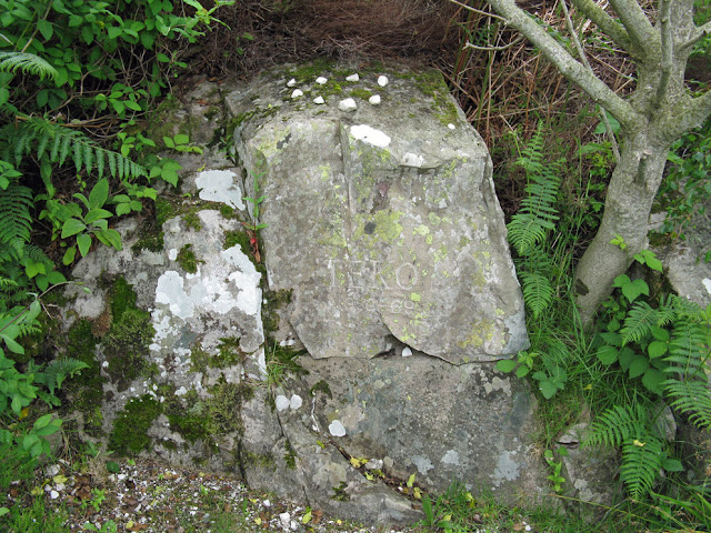
My next Maxwell pilgrimage was to Eilean Bhan, the lighthouse island now under the Skye Bridge, that Maxwell owned for a while (see the July 18, 2013 post). Of all the Maxwell sites, Eilean Bhan is the easiest to visit, as there are regular tours. On the tour you will be able to see inside the cottage, climb the lighthouse, visit a beautiful wildlife hide, and see Teko's memorial stone.

View from the top of Eilean Bhan lighthouse

Teko's memorial stone
Of course the premiere Maxwell pilgrimage site is Sandaig, a small bay south of Eilean Bhan, and the site of his Camusfearna. I made the hike there last year (see the August 30, 2016 post).  A memorial to Maxwell lies on the site of his house, which burned in 1968. Under some nearby trees is Edal's memorial, the Ring of Bright Water otter that died in the fire.


There was still one remaining Maxwell site I wanted to see; so before heading to the Western Isles last July my wife and I spent a few days at the Eilean Iarmain Hotel on Skye. On the first full day, which was overcast with occasional rain showers, I checked the tide tables. Low water was at 4pm, and so at 2pm I left the hotel to walk a short way to the shore. Off to the east lay my destination: the lighthouse of Isle Ornsay. Along with the cottages on Eilean Bhan, five miles to the northeast, Maxwell bought the Ornsay cottages in 1961 (some sources say 1966).


The tide flats were a bit muddy, but very walkable if I kept close to the shore. The total distance to the lighthouse is a mile, and the halfway point is the island of Ornsay. The lighthouse is actually on yet another tidal island, Eilean Sionnaich, which means either fox or seagull island. I would guess the latter definition is correct, as there were no foxes around, but there were plenty of gulls wheeling high overhead.

Tide flats to Isle Ornsay (at left)
Low tide crossing to Eilean Sionnaich
A curious set of seahorse-balustrades topped the seawall that guards the tidal track up to the island. (Or maybe they're water-horses?)


Just above the seawall lay the forlorn walled garden. A garden of grass and weeds; it's been a long time since any crops have been cultivated here.


Between the garden and the lighthouse stood the two side by side cottages. Maxwell's intent for the cottages, as well as those on Eilean Bhan, is summarized in this excerpt from Richard Frere's excellent book Maxwell's Ghost:  'His idea was to renovate his purchases and, using their splendid wild situations and his well-known name as joint inducements, let them to the public at enormous rents.'


As described in Frere's book, the Isle Ornsay cottages were refurbished and let out to holiday makers during Maxwell's ownership. These days the cottages are private residences for the Sedgwicks. They are fortunate to have a place like this. In an area busy with tourists a more isolated place would be hard to find. (Except for the occasional nosy hiker passing by.)


There was no one in residence when I visited. Which was for the best, as I would not have gone near the cottages if anyone was there. For that matter, I'd have felt awkward even passing near them to see the lighthouse. Set next to the cottages is a beautiful memorial stone to the actress Paulita Sedgwick.


Just beyond the cottages a walkway leads to the lighthouse. On 10 November 1857, both this light, and the one on Eilean Bhan, became operational. Keepers lived here until automation came in the early 1960s.


I enjoyed a snack before crossing back across the still dry shingle beach to Isle Ornsay. Before continuing I took a look at the map, and noticed there was a burial ground and chapel site on the nearby slopes of Isle Ornsay. I love finding these old chapels, and since the tide was still out I had time to look for it.

Once on Ornsay I made my way across a soggy field carpeted with tall grass. Since you can not see the ground, it can be treacherous to cross this kind of terrain. So I slowly made my way to a gate in a fence; a wire fence that seemed to encircle the whole island. Greeting me at the gate was a sign, its red letters not specifically saying 'KEEP OUT', but words to that effect: 'Please respect the privacy of the owner, and keep to the shore side of the fence.'


I would indeed respect their privacy by avoiding any houses. But I had every right to look for the old burial ground and chapel. So I climbed the fence and hiked up the grassy hillside. There was no trace of a chapel ruin that was seen here in 1928, but I knew I was in the right place because of a large, worn tombstone, on a level site that looked over to the lighthouse. (See this CANMORE page for more on the chapel that once stood here.)


It was a beautiful spot, and the owners have done a wonderful job of landscaping.


After enjoying this lovely place for a while I headed back to the shore to follow a meager path to the tidal crossing. The return to Skye was as messy as the walk out, as the route is half on gravel, half on mud flats. Even so, I meandered a little, taking time to explore two small islets before the tide isolated them. Along the way there were good views over to the hotel - the pub looked especially inviting.


After changing out of my muddy pants my wife and I enjoyed an excellent meal at the pub. After that we walked to the shore below the hotel. The tide was high, and Eilean Sionnaich was, once again, an island; its tower lit to a brilliant white by the setting sun.

Tuesday, August 22, 2017

The Great Bernera Mill

For me, seeing the restored Great Bernera Norse Mill was a two-year challenge. I first saw it from the sea in 2015 (see the June 30, 2015 post). It looked so intriguing I promised myself that someday I'd take the time to walk to it.


And so, a year later, with Explorer Map 458 in hand, I walked to the end of the road east of the Bernera Museum. The map showed a dotted line path that went directly to the mill, a quarter-mile farther east. All I saw at the road's end was a gate leading into a marshy field. There was nary a trace of a path of any kind, and it looked so swampy I knew I'd sink to my knees if I tried to cross it. You can see the gate to nowhere at the left in the following photo.


I scratched my head, looked at the map again, and gave up. It was late in the day, and the museum was closed. With no one around to ask directions I drove to the Bernera Mini-Mart. I showed the man on duty the map. He had no idea where the path was.

I then drove the east Bernera circuit road looking for a way to the shore. I saw nothing that looked doable, and gave up. My wife and I were returning to the mainland the next day, so I had to put seeing the mill on the list for next time.

So, fast forward to last month. My wife and I were staying on Great Bernera for a week. On a clear, sunny day I set out to visit the mill. I asked for directions at the museum, telling them about my previous failed attempt. They told me to simply follow the red marker posts, and so I returned to that same road's end I'd visited the year before. There were no red posts anywhere, just that same swampy field beyond a gate; a gate that looked like it had not been opened in years.

I returned to the museum and told them so. The woman on duty said there'd been some 'vandalism'. What! Vandals attacking marker posts on Great Bernera?  This was certainly odd. Then she gave me the key to the mill; not a real key, just a suggestion. I needed to walk right up to the house at the end of the road, which you can see to the upper right in the previous photo.

And so I walked up to the house. And there it was. Just to the left of the driveway stood another gate not visible from the road below. This must be the place. But there was no red marker post, or a sign of any kind. Very odd.


I could be wrong, but I surmised the 'vandalism' was that the marker post had been removed to discourage walkers from passing so close to the houses. After following the path past the house I finally came across a red post, one not visible from the road.


From there a series of posts led east over a hill. From there ten minutes of walking brought me to the mill on the shore of Loch Riosaigh.


It was fantastic, like stepping back in time. The mill was used until the 1920s, and had been rebuilt in 1995. Its restored thatch roof was mostly intact, and along the side of the building the mill race flowed to the sea. 


Water in the mill race could be redirected to flow through the lower level of the mill to turn the paddle-wheel. But the water was not going that way so, torch in hand, I entered the dark opening to see the wheel.


On the upper level of the mill were the two millstones, and a wood funnel used to pour grain into the stones.


I then thought about visiting the giant lobster pond and dam on the far side Loch Riosaigh. I'd seen it from the sea back in 2015, and it looked like quite an impressive structure. It is one of the largest lobster ponds in the isles, and was in use until the 1960s. (You can read more here.) 


The pond was only 500 meters away. But getting there involves following the rough coastline around the head of the loch, a distance of 1000 meters. It was getting late, and so I decided to save it for next time. Before heading back I walked out to the tip of a small headland east of the mill, as I'd seen some sort of structure there. On reaching it I discovered it was just a large cairn, probably built by hikers taking a break in this beautiful spot. I left my own mark by building a portal dolmen from three large stones.


Looking at my handiwork I started chucking to myself. I'd suddenly recalled a hilarious event that happened many years ago in the west of Ireland. I was at the Polnabrone Portal Dolmen, one of the most impressive dolmens in the world. I was with Gloria and Regina, two of my nieces. After seeing the dolmen we walked out onto the rocky terrain of the Burren, where we sat down and set about building our own mini-dolmens from the many flat stones that covered the area; none of them more than six inches high. No sooner had we finished when we heard stomping behind us. Up walked the site warden, who proceeded to knock down our creations. He seemed to think future researchers would confuse our little dolmens with the real thing.  

There was no warden at the mill to knock down my creation, only the coming winter storms. I left the headland and made the short walk back to the road. At the hidden gate I was tempted to transplant one of the red posts to it, so it would be visible from the road. But it would probably disappear, too.

Now that you know the way, if you are ever on Great Bernera be sure to visit the mill. It is well worth the short walk. You can read more about the mill here.

Wednesday, August 16, 2017

A Walk to the Aird Mhor

In July I made a three-day hike from Morsgail to the Aird Mhor on the far southwestern tip of Lewis. The journey was made to photograph some of the more intact beehive cells and shielings found in one of the most remote places in the Hebrides. The story of the walk, which followed the route shown below, can be found on the Aird Mhor Walk tab.


Beehive cell above Loch Reasort

2018 Guided Cruise - One Spot Left

Get it before it's gone! There is only one remaining spot on the 2018 Guide Cruise (for a male sharing a twin cabin). Our voyage will focus on islands to the south and west of Oban; including Oronsay and the Garvellachs. If conditions permit, we'll head as far south as CĂ ra. For more information see the 2018 Cruise tab. To book see the Northern Lights website.

Prior Colin's Cross - Oronsay