Thursday, July 28, 2016

Islands in the Sound

Early on May 25 Hjalmar Bjorge weighed anchor and we left our calm anchorage off the island of Scarp. A course was set to the southeast, to visit two islands in the Sound of Harris. (One of my favourite books about these islands is Islands in the Sound, by Alison Johnson). The islands we hoped to visit were Pabbay and Boreray, I was not 100% certain we'd find any anchorages near those islands, as the sound is notoriously shallow. But our expert skipper, Mark Henrys, was able to find a place to drop the hook near Pabbay, and we were soon ashore. 

Pabbay
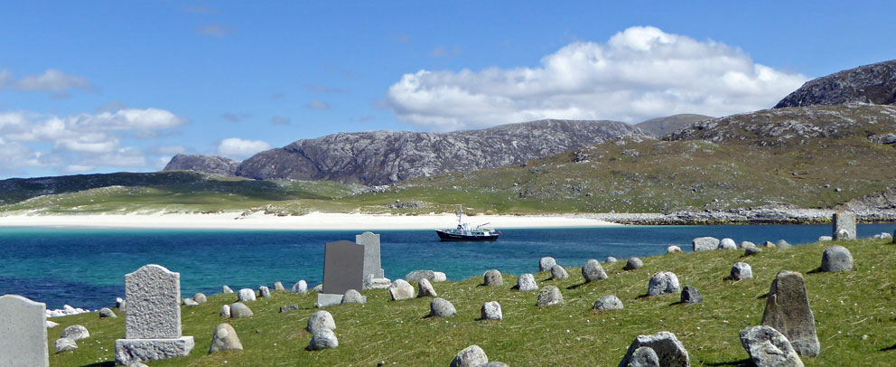
We made a tour of Baile na Cille, which had been the main settlement on Pabbay, centered around the ruin of Teampull Mhoire. The church dates to the 1500s, and replaced an earlier church dedicated to St Moluag.

Teampull Mhoire
The cross inside Teampull Mhore, with its worn arms and tilted head, is eerie, but beautiful. It is mentioned in a book about Pabbay written by Bill Lawson - The Teampull on the Isle of Pabbay (1994). In it he mentions the cross is referred to in A Song of Fear by the Pabbay bard Neil Morrison, as chrois Phapanaich (the Catholic cross). The song calls the ‘Priest’s Temple’ a fearful thing, and that its cross would frighten the very giants.

The cross that would frighten giants
In Baile Lingay, a village above the church, we found the ruin of a large grain drying kiln. Pabbay was known as the granary of Harris, but it also had a good number of its own people to support. In the nineteenth century the population exceeded 300. Most of them were evicted when the island was cleared for sheep in the 1840s. 

Kiln
Kiln in Baile Lingay
It was a beautiful, sunny day, and it was hard to leave Pabbay, but another island called; Boreray, which lay three miles away. Again, Mark was able to find a perfect anchorage in the shallow water off the south tip of Boreray, where we went ashore for a few hours of exploration.

Boreray Arrival
Boreray had a population of almost 200 in the 1840s, but by 1923 only one family remained. (Its current population is one.) Once ashore we made a circular walk around Loch Mor, which nearly divides the island in half.

Loch Mor
It was hard and slow going over the boulders that make up the large storm beach that divides Loch Mor from the sea.

Across the stone beach between Loch Mor and the sea
Loch Mor (right)
We then made our way to the main settlement site on the east side of the island, where I was saddened to see that the Boreray church, which dates to the 1880s, is in even sadder shape than when I visited in 2010. With the roof gone, it won't be long until the gables collapse.

Boreray Church - 2016
Boreray Church - 2010
South of the settlement, and above the beach where we landed, stood a large cluster of earthen mounds. They are known as Cladh na Mhanaich (The Monk's burial Ground). Per Martin Martin, writing in 1695, it is where all the monk's who worked north of Eigg were buried; a fascinating possibility, and it seems odd to me that there has never been any archaeological excavations here to determine exactly what lies inside these mysterious mounds.

Cladh na Mhanaich
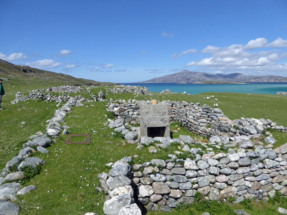
Next to the Monk's Field lie the ruins of a large village, photographed by Erskine Beveridge in 1904 (second photo below).

Boreray Village - 2016
Boreray Village - 1904 (Photo: Erskine Beveridge)
Our time on Boreray was up, and we returned to Hjalmar Bjorge to spend the night. In the morning we set off east through the sound of Harris, passing Rodel and Scalpay as we made our way the 30 miles to the Shiants.

Rodel - church tower at centre
Scalpay
The sea and wind at the Shiants was from the north, which ruled out anchoring in the large bay between the islands. That was a disappointment, at it is the best place to see the hundreds of thousands of puffins that continually fly out to the Minch from their burrows on Garbh Eilean and Eilean Mhuire. And so we had to settle for an anchorage on the west side of the isthmus between Eilean Tighe and Garbh Eilean. As we anchored we watched a two-masted schooner try, and fail, to anchor on the east side.

The schooner attempting to anchor
After anchoring we loaded into the inflatable and went to see if we could get ashore. But the swell and tide were such that we could not find a safe place to land that would also be safe for an uplift later on. As we were looking for a landing I did get onto some rocks off Eilean Tighe, and managed to slowly get ashore near the house on Eilean Tighe. But it was far too slippy and unsafe, and so I was soon back aboard the inflatable. That attempt did allow me to set a record for what may be the shortest visit to the Shiants (three minutes). So we settled in for the night, hoping that conditions would calm overnight.

The next morning was calm and sunny, and so we motored around the giant basalt cliffs of garbh Eilean to drop anchor in the bay between the islands. 

Cliffs of Garbh Eilean
We were only a quarter mile from our last anchorage, on the other side of the isthmus, but what a difference it made. We were now in Puffin country, thousands soaring overhead and paddling on the sea. (See the September 21, 2013 post for a video of the puffin colony on Garbh Eilean.)


We all went ashore on Eilean Tighe to make a tour around the house (built for Compton Mackenzie) and the Iron Age farmstead above it.


Hiking up to the Iron Age farm
Iron Age farm (left)
While up on the summit of the island we saw the Hebridean Princess come into the bay. How dare they invade our private anchorage! But they stayed for only 20 minutes, time to give their passengers a brief taste of the puffins, before moving on.

The Hebridean Princess - now you see her...
Now you don't
While hiking around the island we saw quite a few rat traps, and occasionally we spotted some of the 'rat-hunters' staying on the island, as they walked around to check the traps. They had posted signs saying the Shiants are now thought to be rat-free, and we did not see any.

Hopefully...rat-free
Looking down to the isthmus between Garbh Eilean and Eilean Tighe
Under sunny skies we then raised anchor and set off for our final destination of the cruise: the Small Isles. I knew we'd have time to see Canna and Eigg, but what I did not know was that we'd set foot on all four of the Small Isles.

Thursday, July 21, 2016

Afoot on Scarp

On May 24 we got an early start from the Monachs to make the 40 mile trip north to Scarp. Unfortunately the wind was out of the north, which made the usual Scarp anchorage, on the north side of the sandbar between Scarp and Harris, unworkable. So we motored around the south of Scarp and turned left off the jetty at Huisinis to enter Caolas an Scarp (Kyles of Scarp). Passing Huisinis gave us a good view of the Stiomor, the steep path that leads up and over from Huisinis to Cravadale (see the December 31, 2013 post for a description of walking the Stiomor).

The Stiomor climbing the steep hillside to Cravadale
After dropping anchor in Caolas an Scarp we went ashore to explore the village. There used to be a Gatliffe Trust hostel here, but access to the island was (and still is) so very iffy, that it was only in business for four years (1966-1970). The island was mostly abandoned by 1971.

Scarp village
Hjalmar Bjorge anchored in Caolas an Scarp


We ended our tour of the village by taking a look at the sad remnants of the school, and on a brighter note, going inside the beautifully redone church.


Inside the school
Inside the redone church
I wanted to lead some of the guests up and over the hills to see the two Norse Mills on Allt a' Mhuilinn. But the first priority was to say hello to Brian and Sheila Harper, who live on Scarp for most of the spring and summer every year. I first met them six years ago, and no visit to Scarp is complete without stopping to have tea with this lovely couple.

After tea we set out to climb the hill pass between the two peaks of Beinn fo Tuath, and then on to the summit of the higher peak. As you can see in the photo below, on a sunny day the view west to Lochs Resort, Tealsavay, and Hamanavay is amazing.

The view to Loch Resort, Tealsavay, and Hamanavay
From the summit of Beinn fo Tuath a gentle descent was made west into the rocky interior of Scarp. I was leading Clare and Nigel to see the Norse Mills, but I led them astray at one point, and we had to backtrack a bit to find the stream that flows out of Loch a Mhuilinn (Mill Loch). Halfway between the loch and the sea we found the mills, their millstones still in place. For more photos of the Scarp mills see the March 16, 2013 post.

Mill
Next up was a walk down to Mol Mor. Its Gaelic name means big pebbly beach, but it's better known as Treasure Beach, for the occasional treasures that wash ashore. We found no treasure on our walk, just a trove of colorful plastic flotsam.

Mol Mor (AKA Treasure beach)
There was hardly a cloud in the sky as we made our way back to the vllage by walking around the south tip of the island. At one point we made a brief detour up the hillside to take a close look at Carn Choinnich Shaoir (Kenneth's Cairn). A rusting plaque on the cairn reads:

THIS CAIRN WAS BUILT BY
THE REV. DR. KENNETH MACLENNAN  BA. B.D. M.A. PhD
(COINNEACH SAOR) WHEN HE WAS A BOY IN SCARP
BORN IN TARBERT 21ST JUNE 1867
GRADUATE OF McGILL UNIVERSITY, TORONTO
AND WOOLSTER UNIVERSITY, OHIO
MINISTER OF THE PRESBYTERIAN CHURCH OF CANADA
THE UNITED FREE CHURCH OF SCOTLAND
AND THE CHURCH OF SCOTLAND
MISSIONARY IN HONAN, CHINA 1893-1897
DIED IN TORONTO 11 JUNE 1943
"CUIMHN IS IOMRADH MAITH"

Kenneth's Cairn
I am not sure what 'Cuimhn is Iomradh Maith" means: perhaps 'Remembrance and good account'. If anyone has a better translation please let me know.

We were soon back at the village, and after saying goodbye to Brian and Sheila we boarded the inflatable to return to Hjalmar Bjorge for the night. Unfortunately, the forecast ruled out making a dash out to the Flannans the following morning. It was a disappointment, but one I'm used to. Out of five attempts to get to the Flannans over the years, only one has been successful. On next year's guide-trip we'll make another try.

In the morning we set course to two of my favorite islands in the Sound of Harris: Pabbay and Boreray. My visits to those islands in the past were on shallow draught boats, so the question was whether we'd be able to find a decent anchorage for the 91-ton Hjalmar Bjorge in the shallow water near those islands. Fingers crossed, we set out to take a look.


Sunday, July 17, 2016

A Visit to the Monachs

Early on May 23rd Hjalmar Bjorge motored out of Vatersay Bay and headed up and around the east coast of Barra. As we traversed the Sound of Barra we were rewarded with a close up view of Riever's Castle, which stands atop one of the the small Stack Islands next to Eriskay. The castle was the stronghold of the raider known as Reaubaidair Stache, the subject of the October 8, 2015 post.

Riever's Castle - 1
Riever's Castle - 2
After passing Eriskay we sailed 30 miles north to the Monach Islands; a small group of sandy isles that are one of my favourite places. The three main Monach isles are connected together at low tide and, as the tide was low, after landing on the beach of Ceann Iar we were able to walk over to Shivinish. Even though the tide was on the rise, Lynda made a run for it and continued on to wade across to the main island of Ceann Ear

Lynda running across the sands to Ceann Ear
Ceann Iar is a very special island to me, as it was the first truly remote Scottish island I ever visited. That was during a sailing trip to St Kilda nearly 20 years ago when, after setting sail from Berneray, we anchored at the Monachs before heading to out to Kilda (see chapter 14 of book 2). There are the ruins of three small settlements on Ceann Iar, which we visited as we wandered around the island.

Settlement ruins - Ceann Iar
Fulmars were nesting just about everywhere on the island, including in the old houses. At one point a nest was nearly stepped into while descending a sandbank. It was fortunate that the nest was not damaged, and also that I did not get hit with any fulmar vomit - as they like to spit their foul smelling stomach oil at anyone who threatens them.

Fulmars nesting in the sand
At the westernmost point of the island we came to a beautiful little beach with a good view over to the lighthouse island of Shillay, which was visited in the January 19, 2015 post.

Shillay view
West end beach
Standing above the beach at the west end is a tombstone of a sailor who washed ashore during WWI. Its metal plaque reads: 

LIEUTENANT RNR 
W.A. MC NEILL
HMS LAURENTIC
25TH JANUARY 1917

Lieutenant William McNeill was from Orkney, and died when the Laurentic hit a mine off the coast of Donegal, some 150 miles due south of the Monachs (see this link for more).

Gravesite - Lieutenant William McNeill
Grave of Lt William McNeill
We then explored the ruins of several dwellings as we meandered back to the main beach. We still had more time ashore, and so we settled in on the sand banks above the beach to watch the seals watch us; hundreds were in the water, waiting for us to leave their island.


We'd had a great day ashore, and once back aboard we had an excellent meal before settling in for the night. As we were eating several other ships came in to anchor, including a boat I've always wanted to sail on, MV Cuma, skippered by Murdo Macdonald.

MV Cuma
After a calm night we lifted anchor and motored around the west side of Shillay. (Aside from St Kilda, Shillay is the farthest west of the Western Islands). We then turned north to set a course to our next destination, the island of Scarp. After that, if conditions were good, we hoped to make a dash out to the Flannans.

West side of Shillay

Friday, July 8, 2016

Pabbay & Vatersay Revisited

On May 21st the ship Hjalmar Bjorge left Oban. Aboard were Joey, Patricia, Janet, John, Francis, Elaine, Clare, Nigel, and myself. There were three crew; skipper Mark, his wife Anna, and Lynda the cook. It was my first cruise acting as a guide, and I was a uncertain as to how the next 10 days would go. But I was certain that the selection of islands we hoped to visit would offer some amazing experiences.

After a calm night at anchor in Tobermory Bay we set out the next morning to attempt to land on Pabbay, a deserted island south of Barra. Under partly sunny skies we approached Pabbay from the east, the white sand beach of Traigh Bhan glowing in occasional sunshine. In short order we were ashore, and made our way to the ruins of what had been Pabbay's only village.

Ashore on Pabbay
I'd only been to Pabbay once before, back in 2007 on the boat Boy James, skippered by Donald Macleod (see book 2, chapter 9). Aside from wanting to return to a beautiful and historic island, I wanted to see how they'd permanently mounted its amazing Pictish Symbol stone.

We all made our way across the sands to the village, which was last occupied in 1911. Its cluster of black houses have been drastically altered into sheep pens, and standing above them is the shell of Taigh nam Bochdan, the house of spectres. I will not recount the long, strange history of this haunted house, but you can find it in chapter 9 of book 2.


Taigh nam Bochdan
Next to the village is Pabbay's massive burial mound. There used to be a chapel on it, but there's no sign of it these days. At the base of the mound stands the symbol stone. When I saw it in 2007 it was lying prone, as if it had been tossed aside. But a few years ago they securely mounted it upright. I was happy to see they've done that, and that its carvings are no longer subject to direct rainfall and the feet of uncaring visitors.

Mark & Anna on the burial mound - symbol stone at base
Even though they did good work by mounting the stone upright, it is something that should have been done a very long time ago; for the mysterious Pictish symbols, the crescent/v-rod, and the lily, are so badly worn that there is not much left of them. The next photo shows the side of the stone with the symbols, but you can not see them. All that's visible is the Christian cross at the top, a later addition to the stone. For a better (and much older) photo see page 87 of book 2 (or this CANMORE page).

The worn symbol stone
After we explored the village I led a group over a grassy ridge to Dunan Ruadh, a broch ruin on the east coast of the island. The broch was in direct line-of-sight with Dun Sandray, a broch on the island of Sandray, three miles to the northeast. The brochs were located such that a fire beacon could easily relay news from island to island that unfriendly visitors were in the area.

Dunan Ruadh - Sandray in the distance
Dunan Ruadh
The climb over to Dunan Ruadh was hard going through the thick, tall grass that covers most of the island, which makes Pabbay one of the harder islands to explore on foot. After a few hours ashore we gathered back at the beach to board the inflatable and return to Hjalmar Bjorge. Pabbay was an excellent first island of the trip, and next up was nearby Sandray.

Pabbay anchorage
But when we went to take a look at the Sandray beach landing, it was too swelly, and so we made our way to anchor for the night in the east bay of Vatersay. There were only a few clouds in the sky, and as there were several hours of daylight left we went ashore for a walk.

East Bay - Vatersay
No visit to Vatersay is complete without seeing the Annie Jane memorial, and so we paid our respects to the site where over 300 people are buried who drowned when the immigrant ship Anne Jane ran aground in 1853. You can find a list of the victims here.

Annie Jane Monument
After over 150 years of blowing sand the words carved at the base of the monument are hard to read. Fortunately I copied them down when I first visited Vatersay in 1998:


ON 28th SEPR 1853 THE SHIP ANNIE JANE WITH EMIGRANTS 
FROM LIVERPOOL TO QUEBEC WAS TOTALLY WRECKED IN THIS BAY AND
THREEFOURTHS OF THE CREW AND PASSENGERS NUMBERING 
ABOUT 350 MEN WOMEN AND CHILDREN WERE DROWNED AND 
THEIR BODIES INTERRED HERE
AND THE SEA GAVE UP THE DEAD WHICH WERE IN IT   REV: XX 13

I've visited the monument many times over the years, but this time I noticed something different. In the sand next to the obelisk was a board with an old black & white drawing of a man; its title read: Jean Vernier (1822-1853). Reverend Jean Vernier was one of eight members of the French Canadian Missionary Society who were returning to Canada on the Annie Jane. The reverend, and four others of his group did not survive the shipwreck.

Jean Vernier (1822-1853)
On the walk back to the beach we met the woman who owns the old Vatersay school house, which is now one-half private residence, one half a self catering apartment. The woman's dog gave Nigel a good workout by playing fetch with him on the beach.

Fetch on the beach - old Vatersay schoolhouse in the distance (right)

In the morning we set out for our next destination - the Monach Isles. We did not know it at the time, but over the next 10 days we would be blessed with non-stop sunshine.

Friday, July 1, 2016

Oronsay - 23 Years On

Another island I made a long-awaited return to last month was Oronsay. I first visited this tidal island in 1993, when my wife and I reached it the traditional way by wading from Colonsay at low tide.

Shawna crossing the strand to Oronsay in 1993
Halfway across the strand we had to take our shoes off in order to cross a tidal stream. It was cold going, but in short order we made a wet-foot landfall on Oronsay. On my return visit to Oronsay last month aboard Elizabeth G my feet did not get cold, as we made a dry-foot beach landing from an inflatable at Port na-h-Atha, a sandy beach on the east coast of Oronsay.

Beach landing at Port na-h-Atha
From the beach a pleasant mile-long walk took us to the priory ruins. The caretakers have a good sense of humor; the first thing we saw when we approached the priory was a 'Car Park' sign.

The car park
The highlights of Oronsay are Prior Colin's Cross and the collection of carved tombstones kept in what's usually called the Prior's House, but what was once a barn. The barn itself has a sinister history. Although Oronsay was considered a sanctuary island, some 500 years ago Alexander Macdonald of Lochalsh was murdered in the barn by MacIain of Ardnamurchan. (MacIain did this in order to curry favor with the Duke of Argyle - see chapter 3 (page 154) of MEM's Further Wanderings, Mainly in Argyll.)

Prior Colin's Cross
Medieval Tombstones in the barn where Alexander Macdonald was murdered
The main thing I wanted to do on Oronsay was to climb up to Carn Cul ri Eirinn (the cairn looking away from Ireland). There is another Carn Cul ri Eirinn 20 miles to the north on Iona, and 30 miles to the northwest on Mull lies Carn Cul ri Albainn. It has been suggested that these cairns defined the border between Dalriada of the Scots, and Alba, the land of the Picts.


From left to right: Carn Cul ri Eirinn (Oronsay); Carn Cul ri Eirinn (Iona); Carn Cul ri Albainn (Mull)
On that visit to Oronsay in 1993 I ended up with only one (not very good) photo of Oronsay's Carn Cul ri Eirinn. This time I climbed the hill looking forward to getting more photos of the top of Beinn Oronsay and Carn Cul ri Eirinn. On the way up some beautiful views opened up over the priory and the surrounding islands.

The Priory
Carn Cul ri Eirinn (Oronsay)
The top of Oronsay is a beautiful spot, with views north to Colonsay, south to Islay, east to Jura, and west to the open sea. I sat there for a while before heading down to the strand to find the spot where my wife and I had made landfall on Oronsay 23 years ago.


The view from Carn Cul ri Eirinn - looking away from Ireland across the strand to Colonsay 
Note: This post marks the end of the descriptions of my travels last month on Elizabeth G with members of the St Kilda Club. I'd like to thank Christina, Viv, Margaret, Marion, Liz, Keith, Chris, Jeff, Jim, and John for being such good company. Also many thanks to the crew; Rob, Pip, and Connor, for such a great experience. Beginning with the next post we will travel to the 12 islands visited by Hjalmar Bjorge from May 21-31.