
While researching the locations of beehive cells on Lewis I came across a reference to a linear layout of three cells on the north side of Eilean Chaluim Chille. I had been to the island, which lies near the mouth of Loch Eireasort (eastern Lewis), a couple of times. Those visits had been made to see the ruins of Eaglais Chaluim Chille, St Columba's Church. (For a description of Eaglais Chaluim Chille see the April 8, 2014 and April 13, 2014 posts, and Book 2, chapter 28).
 |
| Eaglais Chaluim Chille |
But on those previous visits I'd never been across to the island's northern side, where the beehive cells were said to be. So this August I visited Eilean Chaluim Chille with John Randall to see if we could find the cells. I'd made several walks with John in the past, most recently in July of 2017, when we made a long hike from Loch Claidh to Eisgean (see the August 11, 2017 post).
Our hike around Eilean Chaluim Chille began on a wet August morning by crossing to the island from mainland Lewis, via the tidal causeway near the village of Cromore.

Our hike around Eilean Chaluim Chille began on a wet August morning by crossing to the island from mainland Lewis, via the tidal causeway near the village of Cromore.
 |
| The causeway before low tide |
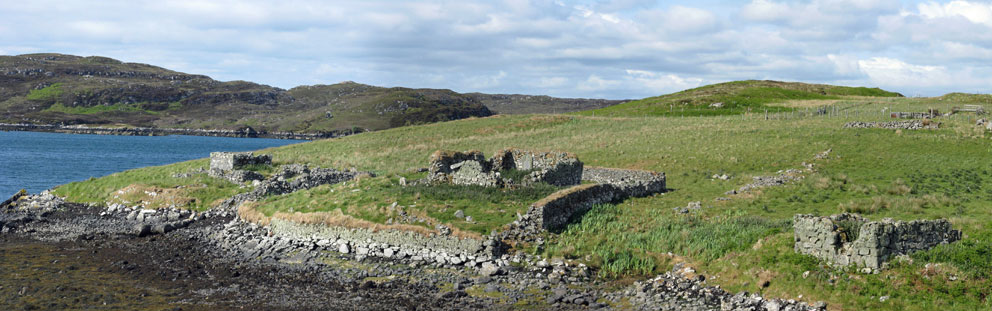
From the causeway we hiked southwest past Eaglais Chaluim Chille, where a monastery was established around the 9th century. (The ruins on the site date to the 12th century). Along the way we passed a modern burial enclosure. In it lies the grave of Charles Menedez Macleod, the first Charlie Barley of Charles Macleod Stornoway Black Pudding fame.

From the ruins of St Columba's Church we turned north to cut across the centre of the island. The grass, bracken, and heather were thick and wet, which made the going difficult. After a half hour we came to a low cliff that overlooked a small bay.

A hard trudge through the wet heather below the cliff led us to the ruins of the beehives. The searcher for beehive cells encounters many highs, and lows; this was not a high, as the ruins were almost completely collapsed; their circular foundations barely visible in the thick, wet vegetation. But the site itself was spectacular, overlooking the islet-studded mouth of Loch Eireasort.
 |
| The three beehive ruins barely visible in the bracken |
From the ruins we hiked northeast past Port nam Marbh (the port of the dead), where funeral processions landed to take the bodies to the burial ground near the church. (The graveyard was used into the 19th century.) From there we passed Loch na Muilne (mill-loch) and carried on to Dubh Thob (the dark bay), at the northeast tip of the island. Across the bay rose the rocky summit of Crois Eilean (Cross Island). At low tide this small islet is connected to Eilean Chaluim Chille. Since the tide was still out we made our way to the narrow crossing.
 |
| Cross Island |
An easy climb of 75 feet took us to the top of Cross Island. At its summit stood a large cairn; one that, based on the name of the island, may have once been the base of a cross that long ago signified to the sea-traveller that they were nearing the monastery of Eilean Chaluim Chille.
 |
| Cross-base cairn Crois Eilean |
Any visit to Eilean Chaluim Chille requires you keep an eye on the tide. But from the top of Crois Eilean we could see the tide was still low; and as it was only a half-mile back to the causeway there was no need to rush. As most of our walk had been, the return to the causeway was across rough, wet terrain. Nearing the causeway we could see that all the island's sheep had decided it was also time to return to the mainland. And so, before the rising sea made Eilean Chaluim Chille an island once again, we followed them back across the causeway.

John and I had spent a day trekking over a part of Eilean Chaluim Chille that neither of us has been to before; we'd not found any intact beehive cells but, just as fascinating, we'd set foot on new ground, a part of an historic Hebridean island we'd not seen before. Something you don't often get the chance to do.
No comments:
Post a Comment