
The wind was blowing, but the sun was shining, on Wednesday morning (Sept 11), my second full day on Islay. The forecast for the next day was heavy rain, so I decided to take advantage of the good weather and make a long hike around the Ardnave Peninsula, which would take me to a viewpoint over to Nave Island. I'd been to Nave Island a couple times, and was looking forward to seeing how it looked from mainland Islay. On my first visit to Nave the number of seals had been absolutely stunning, so I was also hoping to see them again.
 |
| Seals off Nave Island - 2016 |
After breakfast I powered up my little hire car and trundled north along the A847 - the brakes grinding and moaning everytime I had to slow down. After passing the Bruicladdaich distillery (oh how good the air smells there) I turned up the B8018 single track. I had a stop to make before reaching Ardnave, as I wanted to visit a site I'd not been to in 20 years. After passing the Kilchoman distillery I turned left and carried on to road's end. I was looking forward to seeing something amazing. But I was to be sorely disappointed.
The disappointment was due to a chain-link fence that completely walled off old Kilchoman Church. Not only was the church inaccessible, so was what I'd come to see - its 15th century high cross. The closest I could get was a spot some 40 feet away on the road.

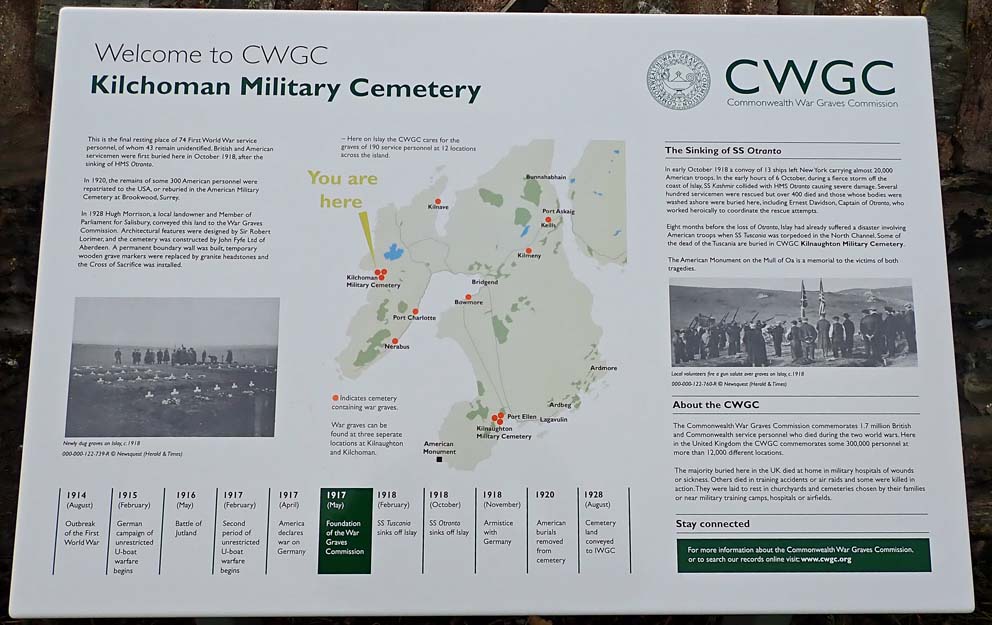
After failing to find a way to get into the old burial ground, I walked over to the Military Cemetery, which lay on the machair 1000 feet to the west. Buried there are victims of the sinking of HMS Otranto in 1918. She was struck by another troopship during a storm, causing the loss of 470 lives, most of them American. Set at one end of the cemetery is the grave of Otranto's Captain, Ernest Davidson.


A short distance from the military cemetery, and just barely standing, is the Kilchoman Santuary Cross. It is beautiful, but not as shiny as when I saw it 20 years ago. Back then the field was full of sheep, who'd buffed the cross to a bright sheen by using it as a scratching post. The cross was also much more tilted than it was back then. Unless something is done to stabilize it, in another 20 years it will probably fall over.
 |
| Sanctuary Cross - 2019 |
 |
| Sanctuary Cross - 20 years ago |
After getting back in my car, and hoping the brakes still worked, I motored east until I found the teeny-tiny single-track that leads north to the Ardnave Peninsula. The public road ended at a parking area on the northeast corner of Ardnave Loch. And as I stepped out of the car I was blasted with a strong wind laced with sand. After putting on a thick sweater I set out on foot to make the four-mile walk around the tip of the peninsula.
A colorful information board had this to say about the wildlife: At Ardnave we are working with SNH to care for the special wildlife found here. Corncrakes are very shy birds, so to encourage them, we leave patches of long grass for them to hide in. Choughs prefer short grass with plenty of cow pats (full of tasty beetles and grubs). By keeping cattle outside during the winter we are supplying ready meals for the young chough.
A colorful information board had this to say about the wildlife: At Ardnave we are working with SNH to care for the special wildlife found here. Corncrakes are very shy birds, so to encourage them, we leave patches of long grass for them to hide in. Choughs prefer short grass with plenty of cow pats (full of tasty beetles and grubs). By keeping cattle outside during the winter we are supplying ready meals for the young chough.

It was a beautiful, wind-blown hike up the east side of the peninsula, following a sandy farm track across the rolling grassland.

I heard no corncrakes, and did not see any choughs as I walked out to the end of the peninsula. I did, however, see a lot of cattle, and loads of cow pats filled with tasty beetles and grubs. I assumed they were tasty, anyway - I decided to munch on a chocolate bar instead. As I approached the viewpoint over Nave Island I saw what looked like a small prison cell on the machair. On closer inspection it turned out to be a very heavily protected grave. Buried here in this special spot are Archibald McDonald (1803-1873), and Duncan Campbell (1753-1825). The tombstone reported that Campbell was 'interred in this spot by his own particular desire'. Duncan Campbell is said to have built Ardnave House (which we'll see at the end of the walk).


From the grave I carried on north across the gentle dunes to Cnoc na Faire - lookout hill. Lying a third of a mile across the rippling waters of the sea lay Nave Island. It was a stunning sight, but there were no seals singing in the sea as when I visited the island in 2016.


After enjoying a beer while seated in the dunes overlooking the island I headed south, back over the dunes, to start down the western shore of the peninsula. In the dunes here there are said to be the ruin of a roundhouse, but I was unable to find it. As I carried on to the south I could see the headland at Sanaigmore, where I'd walked the day before.

Eventually the walk reached a track that lead through the back side of Ardnave farm. Several of the local residents stuck their heads out of the feed troughs to see what I was up to. As I walked past them, the smells of crusted cow pats aside, I truly appreciated walking in Scotland. You are very blessed here; the right to roam, and the farmers who willingly invite walkers to pass across their lands, is wonderful - and in stark contrast to what I would experience in Ireland in the coming week.

The walk came to an end on the shore of Ardnave Loch, just below the front of Ardnave House (early 19th century). It had been an exhilarating walk, especially as I'd had to fight the wind with every step. You can find the Walk Highlands description of the Ardnave walk here.

There was still a lot of daylight left, so as I drove out past Ardnave Loch I decided to pay a visit to Kilnave Chapel. It lies quite a ways off the road, but it was a pleasant stroll down to the chapel through a field full of fat, content-looking sheep.


The lichen-grown cross (5th century) and chapel are iconic symbols of Islay, and on that blustery September day I had the place all to myself. The tide was out and shallow Loch Gruinart showed more sand than water.


As I left Kilnave it started to cloud up, and I felt a few drops of rain. But as there was still an hour or two of daylight, I decided to make one last stop. I would visit the most historic site on Islay: Finlaggan of the Lords of the Isles.
I had visited Finlaggan a long time ago. It was the one-time seat of the Lord of the Isles, and my wife and I had got to the island in the loch, Eilean Mor, by stepping onto a small barge, and then pulling on a rope to haul the barge the short distance to the island. Now, some 20 years later, as I went into the visitor centre I was told the barge had been replaced with a footbridge. But there was a bit of a problem. With all the recent rains the approach to the footbridge was submerged. But fortunately they had wellies to loan out, and so after swapping my hiking boots for wellies, I started down the path to the bridge.


The path was indeed underwater. But confidant in my wellies I strode forward - but a bit to rashly. Halfway through the flooded path my right foot plunged into a hidden hole, some two-feet deep. In an instant the welly filled with brown, cold, peaty water.

I was able to extract myself from the hole, and quickly made my way to the part of the footbridge that was above water. There I pulled off the water-filled welly to dump its contents back into the stream. After wringing out the soaked sock, I put the welly back on and proceeded across the bridge to the island.

The ruins on Eilean Mor are extensive, dating from the 13th through the 16th century. The chapel here is dedicated to the 6th century St Findlugan - a possible source for the name of the site.


If I was up for a swim, I'd have made my way across the 150 feet of water between Eilean Mor and Eilean na Comhairle (Council Island). There was once a large fortification on that small island, and it was the meeting place of the council of the isles. All of this came to an end around the year 1494, when most of the buildings on Council Island and Eilean Mor were knocked down.


As I crossed back to the mainland I was able to avoid the big hole, and at the visitor center I exchanged wet wellies for warm and dry boots. The centre had an interesting virtual reality exhibit where, while sitting in a chair, I put on the VR headset, and was able to 'walk' through a reconstruction of the site. It was fascinating, but as it did not allow for wearing glasses, it was a bit out of focus and gave me a headache.
As I returned to Port Charlotte and its busy hotel (where you had to book for a bar meal) I thought back on the busy day. I had been privileged to have been near Nave Island and Kilnave, one-time monastic sites where monks long ago possibly ventured out to the hermitage cell I'd visited at Allt nam Ba the day before. I only had one more day on Islay before heading up to Oban. I had no idea how I'd fill it. But as it turned out, it would be one of my best days of island going.

Significance of Kilchoman Military Cemetery gravestone in the form of a cross amongst the rows of standard stones?
ReplyDeleteThe cross marks the grave of Ernest Davidson, the captain of HMS Otranto.
Delete