
After our visit to Inishglora there was not much daylight left, so Mark and Tim decided to make a short motor to an island with a sheltered anchorage that they'd spotted on the chart. Luckily for me, that island was Inishkea North - another of my asterisked isles. We dropped anchor 500 feet off the island in time to have dinner at 8pm. The plan for shore leave was an unusual one. In the morning we'd make a pre-breakfast landing on the island.
Up at the crack of dawn I fortified myself with a cup of coffee laced with chocolate. Breakfast would have to wait - we had an island to see. At 7am we loaded into the inflatable, and then motored across the calm bay to land on the sands of Inishkea North.
Up at the crack of dawn I fortified myself with a cup of coffee laced with chocolate. Breakfast would have to wait - we had an island to see. At 7am we loaded into the inflatable, and then motored across the calm bay to land on the sands of Inishkea North.

Inishkea comes from the Gaelic Inis Gé, which means Goose Island; named for the barnacle geese that spend the winter here. None were about, but over a hundred curlews were on the water. The island hosted a monastery from the 6th thru the 10th century. The only remnants of it are the ruin of a chapel dedicated to St Columba that sits on the highest point on the island, and some tumbled beehive cells atop a large sandhill.
An amazing sight greeted us when we landed: the village ruins lit to a golden hue by the rising sun. The village is named 'Cloughnacallydivva' on the map, which is a corruption of the Gaelic Cloch na Cailli Duibhe, which I believe means something like the stones of the women in black (nuns), similar to Taigh nan Cailleachan Dubha on Lewis.

The village was like a combination of St Kilda and Mingulay; a row of stone houses standing high above the south side of the bay, and another cluster of houses scattered above the north side that are gradually being buried by drifting sand.


Walking through the ruins, one by one in the early morning light, was one of the best island-going experiences ever. I had to think that this is how St Kilda should be: left to gracefully age, instead of being artificially maintained. The village had been quite prosperous in its time, with lots of fertile farmland, and a prosperous fishing industry, including lobster, hake, and shrimp. It was also known for good whisky. Eighteen families were here in 1855 but, like Kilda, the island was abandoned in the 1930s.

The land above the village was crisscrossed by several stone-walled roadways, which I followed to the highest point of the island to get to St Columba's Church.


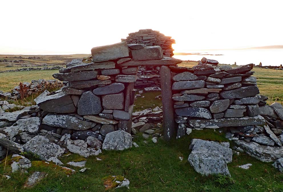 |
| St Columba's Church |
The oddest thing on the island is a giant sandhill. Atop it lies several ruined beehive cells, and at its base is a burial ground dedicated to St Columba. The beehives are marked on the 19th century map as Thurrows, a name for beehive cells not used in Scotland. Another name used for these cells in Ireland is Torthaigh, which shows up on the map of Inishglora and translates as Tower House.

After wandering around the island for another hour I returned to the village, taking advantage of the early morning light to get some more photos.


With 15 minutes left I found a place to sit above the beach. This was the time on an island visit that I usually crack open a beer, but it was a little early for that - even for me.

I could have spent all day here, but we had to be moving on. A gale was brewing. It would arrive in a few days, so we needed to make it at least as far as the Aran Islands (100 miles) by the end of the day. The good news was that the sun was shining, and along the way we'd pay a visit to Inishbofin, the island of the white cow.
For more on Inishkea see this Irish Islands page.
For more on Inishkea see this Irish Islands page.

No comments:
Post a Comment