Saturday, October 13, 2018

The Beehives of Airigh a' Chlàir Mhòir

When I last left you I was battling the midges of Gleann Shanndaig, a remote part of Lewis, three miles east of Kinlochreasort. After a night in the tent I packed up and, walking fast enough to keep ahead of the pursuing midges, set out to find the shieling site known as Airigh a' Chlàir Mhòir.

A bit west of Gleann Shanndaig I rounded the north shoulder of Beinn a' Bhoth, where the vast interior of the Morsgail moorland came into view. Off to the west lay the narrow end of Loch Reasort, and the old lodges at Luachair (Harris - to the left) and Kinlochresort (Lewis).


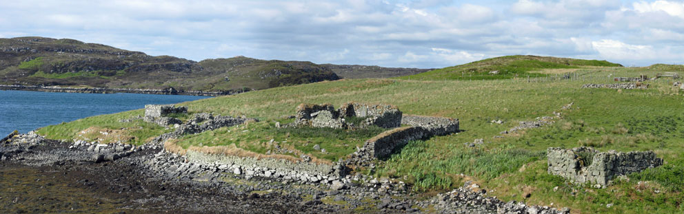
It was a pleasant, warm day, but dark and wet-looking clouds loomed over the Harris hills to the south. As I walked towards them something fascinating slowly became visible in the distance: two grass grown humps rising from the rolling green terrain on the far side of a small stream.


Only after fording the stream did I realize just how fantastic these two structures are. Possibly the most impressive pair of multiple cells I've ever seen - a double double - the Epsilon Lyrae of beehive cells sites.


The easternmost double cell (at left in the above photo) stood six feet tall, and 25 feet in total length. About 80% intact, only the last couple of courses of its two corbelled domes have collapsed. I crawled into the north entrance of the first cell, and was able to continue on my knees through to the second compartment. 


After crawling back outside, over the damp, moss-grown stones that floored the connected cells, I made my way over to the main attraction - one of the biggest beehives I've seen - a double cell with much of its turf covering intact. The largest of the pair was 100% intact, but the adjoining mother-in-law cell has collapsed.

The big cell - collapsed connected cell in the foreground - the other double cell at left
It was a joy to push through the grass that blocked the northern entrance and make my way inside. Once through the low doorway I could stand up, the top of my head just a few inches below the top of the intact dome.


Top of the dome
It had been well worth the two days of hiking it took to reach Airigh a' Chlàir Mhòir. It, and Upper Fidigidh, five mile to the northwest, are the most amazing beehive settlements still standing. After exploring the site I set a course to the northwest, where I hoped to camp for the night by the ruin of the postman's house, where Murdo Crola lived a century ago.

Sunday, October 7, 2018

Gleann Shanndaig - Midge Heaven

A few weeks ago I wrote of a wonderful campsite I had in Glen Shanndaig, on the isle of Lewis. It was an amazing place, where I'd pitched my tent below the ruin of a giant beehive cell. But I did gloss over something. There was a big downside to that spot. Something all who've hiked in the islands are well aware of: midges.


Midges are the bane of all who venture into the interior of the islands where, unless there is a significant breeze, or freezing temperatures, they are ever-present - eagerly waiting to feast on the warm, deliciously fresh blood of weary hikers.


While setting up camp my scalp started to itch. No, not from dandruff (though there may have been some). The itch was due to a million or so midges relentlessly burrowing through my hair in search of the mother lode; in search of a warm and sweet nectar, and a rare one at that. For my blood is a rare vintage in this part of the world (Cascadia 1957 - with hints of Canadian pine and Pacific kelp). An exotic blend not often found in the middle of a Lewis bog.

And so the bugs were in a ecstatic frenzy - drunkenly munching away on every inch of exposed skin and scalp. From their excited cries of ecstasy - over the years my ears have become attuned to midge cries of ecstasy - it appeared they'd never tasted anything so good, and so I had to quickly put on a bug net for protection. I call my net 'a bug hat', as it is a baseball-style cap with a handy net that pulls down over the brim. But it is not fool-proof (and I can be a fool at times). The trick to putting it on is to pull the net down without trapping a few hundred voracious insects inside, all deliriously happy to discover that their competitors have been walled off, and that they, now alone, have a tasty smorgasbord of fresh flesh to dine on.


Once the bug hat was on, and the tent pitched, I crawled inside, where I spent a half-hour trying to kill the thousand or so midges that had managed to get inside with me - I think I got three of them. But three was better than none, and so the mighty midge-killer, his blood-lust quenched for the evening, settled down to spend the night. Eight hours to rest weary legs; eight hours to re-energize enough to carry on across the moorland to visit what would turn out to be the most impressive beehive cell he'd ever seen. Stay tuned.

Monday, October 1, 2018

The Morsgail Beehive Cells

I first visited the Morsgail beehive cells in the year 2000. Since then I have passed by them a dozen times.  Except for a few stretches of soggy bog, the five mile round trip walk is relatively easy. 


The first part of the walk is a level stroll along the paved track to Morsgail Lodge. After a mile a sign once directed walkers away from the track to a footbridge spanning the Morsgail River. (The sign has since disappeared, but the bridge is still there.)

From the bridge an undulating quad-bike path carries on above the eastern shore of Loch Morsgail. You can choose to follow it, or just head generally to the southwest across the moorland. When I first passed this way, 18 years ago, several standing telegraph poles dating to WWI marked part of the route. But aside from a short stump or two they have all disappeared: including seven that were harvested to build a quad-bike bridge over the Beinn na Gile stream adjacent to the beehive cells.


A little over an hour after setting out you will come to the triple beehive dwelling in a shallow valley. The stone-dome of the middle cell is intact, but the domes of its two connected cells have collapsed. 


It is a tranquil, beautiful spot. A substantial foot-bridge once crossed the stream to the south, but all that left of it is an ancient wood plank. When I visited the site a couple of months ago I was tempted to use the precarious plank to cross the stream. But it looked a bit weak, so I used the nearby telegraph-pole bridge instead.


Below is a photo that shows both the cells, and a drawing made when they were completely intact.


The drawing is from an article in the September 1938 edition of Antiquity magazine. It is interesting that the drawing was not made on-site. It is a drawing made of a model of the cells in the Pitt Rivers Museum. I wonder if the model still exists.

Next time you are on Lewis be sure to set aside a day to take a look at these amazing relics of the past. Crawl inside one and think what it would be like to live here. Would you be miserable? Probably. But comfort is relative. When intact these cells were water- and wind-proof. Even more important; with a small fire going they would have been warm and mostly midge-proof. Seventeenth century four-star accommodation, indeed.

Saturday, September 22, 2018

Return to Eilean Chaluim Chille

While researching the locations of beehive cells on Lewis I came across a reference to a linear layout of three cells on the north side of Eilean Chaluim Chille. I had been to the island, which lies near the mouth of Loch Eireasort (eastern Lewis), a couple of times. Those visits had been made to see the ruins of Eaglais Chaluim Chille, St Columba's Church. (For a description of Eaglais Chaluim Chille see the April 8, 2014 and April 13, 2014 posts, and Book 2, chapter 28).

Eaglais Chaluim Chille
But on those previous visits I'd never been across to the island's northern side, where the beehive cells were said to be. So this August I visited Eilean Chaluim Chille with John Randall to see if we could find the cells. I'd made several walks with John in the past, most recently in July of 2017, when we made a long hike from Loch Claidh to Eisgean (see the August 11, 2017 post).

Our hike around Eilean Chaluim Chille began on a wet August morning by crossing to the island from mainland Lewis, via the tidal causeway near the village of Cromore.


The causeway before low tide
From the causeway we hiked southwest past Eaglais Chaluim Chille, where a monastery was established around the 9th century. (The ruins on the site date to the 12th century). Along the way we passed a modern burial enclosure. In it lies the grave of Charles Menedez Macleod, the first Charlie Barley of Charles Macleod Stornoway Black Pudding fame


From the ruins of St Columba's Church we turned north to cut across the centre of the island. The grass, bracken, and heather were thick and wet, which made the going difficult. After a half hour we came to a low cliff that overlooked a small bay.


A hard trudge through the wet heather below the cliff led us to the ruins of the beehives. The searcher for beehive cells encounters many highs, and lows; this was not a high, as the ruins were almost completely collapsed; their circular foundations barely visible in the thick, wet vegetation. But the site itself was spectacular, overlooking the islet-studded mouth of Loch Eireasort.

The three beehive ruins barely visible in the bracken
From the ruins we hiked northeast past Port nam Marbh (the port of the dead), where funeral processions landed to take the bodies to the burial ground near the church. (The graveyard was used into the 19th century.) From there we passed Loch na Muilne (mill-loch) and carried on to Dubh Thob (the dark bay), at the northeast tip of the island. Across the bay rose the rocky summit of Crois Eilean (Cross Island). At low tide this small islet is connected to Eilean Chaluim Chille. Since the tide was still out we made our way to the narrow crossing.  

Cross Island
An easy climb of 75 feet took us to the top of Cross Island. At its summit stood a large cairn; one that, based on the name of the island, may have once been the base of a cross that long ago signified to the sea-traveller that they were nearing the monastery of Eilean Chaluim Chille. 

Cross-base cairn Crois Eilean
Any visit to Eilean Chaluim Chille requires you keep an eye on the tide. But from the top of Crois Eilean we could see the tide was still low; and as it was only a half-mile back to the causeway there was no need to rush. As most of our walk had been, the return to the causeway was across rough, wet terrain. Nearing the causeway we could see that all the island's sheep had decided it was also time to return to the mainland. And so, before the rising sea made Eilean Chaluim Chille an island once again, we followed them back across the causeway. 


John and I had spent a day trekking over a part of Eilean Chaluim Chille that neither of us has been to before; we'd not found any intact beehive cells but, just as fascinating, we'd set foot on new ground, a part of an historic Hebridean island we'd not seen before. Something you don't often get the chance to do.

Wednesday, September 12, 2018

Rona - Ten Months and Counting

Ten months and counting. That's when I hope to return to Rona on Hjalmar Bjorge. I was fortunate, back in 2011, to have visited the island on Hjalmar Bjorge for two consecutive days of perfect weather (see Chapter 29 of Book 2).


There is only one spot left on our 2019 cruise to Rona (for a male sharing a cabin) - see this Northern Lights page for more information; and for more posts on Rona see this link.

Here is a short video that shows what it's like high atop the wheelhouse of Hjalmar Bjorge on the approach to Rona. Come join us for an experience like this; one, among many, you'll never forget.

Friday, September 7, 2018

A Hebridean Campsite

Last month I made a three-day hike into the interior of Lewis. I was searching for beehive cell dwellings, and found plenty: the most amazing at Loch a' Sguair, Gearraidh Ascleit, and another place further south called Airidh a' Chlair Mhoir. Along with the delight of finding intact cells, another satisfying thing during hikes like this is to find a campsite in a beautiful spot, a place to rest and savour the silence.


It was a wet August afternoon when, after exploring the cells at Gearraidh Ascleit, a village of eight beehives, three of them intact, I set out in search of a place to spend the night. I hoped to make it as far as Gleann Shanndaig, where there are many shieling ruins.

Beehive cell at Ascleit - the hill Roineabhal to the right
Glen Shanndaig lies seven kilometres south of Kinlochroag, five east of Kinlochreasort. To get there from Ascleit requires following a zig-zaggy route of five kilometres. First you have to cut across the south shoulder of Ascleit, then cross a stream that flows from a small, unnamed loch into Loch Lomhainn. From there fifteen minutes of hiking leads up to the interesting settlement of Gearraidh Druim Lomhainn: a linear set of four ruined cells spread out on the Druim Lomhainn ridge. 

Gearraidh Druim Lomhainn
My legs were getting weary at that point, but I was still an hour out from Glean Shanndaig. It’s not a straightforward route, as 230 metre high Sgalabhal Shanndaig stands in the way. The hill’s flanks are guarded by the cliffs of Creag Maralltan and Speireag, which forced me to head south to the saddle between Sgalabhal Shanndaig and Sgalabhal Beag. From the pass it was an easy hike down into Gleann Shanndaig.

The lumpy terrain in the glen was confusing: a maze of streams winding to and fro between grass-grown mounds of sand and gravel. The first ruin I came to was a large, tumbled double beehive at NB 150175. It sat just above a small grassy peninsula, nearly an island, surrounded on three sides by a loop of the Abhainn Gleann Shanndaig. The peninsula looked like the perfect campsite, or so my still weary legs were telling me, and so I dropped the pack on the ground.


The tent was pitched, I filtered some icy-cold water from the stream, and then wandered through the glen, on the lookout for intact beehive cells. But there were none to be found. What I did find were a half-dozen collapsed cells, and several rectangular shielings. I ventured farther south to a much larger stream, the Abhainn Gleann a’ Ghàraidh. There were ruins there, too, but none of them beehives.


It was a quiet evening – just the trickle of the stream breaking the silence. The Perseid meteor shower peaked that night (Aug 12); but if there were any shooting-stars to see they were hidden behind heavy clouds. In the morning I set out, under a light rain, to search for more beehives. I would be successful in that. I would also be successful in finding yet another outstanding campsite on the far shores of Loch Reasort.

Saturday, September 1, 2018

A Monastic Retreat in the Hills of Uig

I was about to give up the search. I'd hiked southwest for nearly an hour from the road at Cairisiadar; first along an old peat track, which had petered out after a half-mile, and then up the slopes of Cleite na Crich, one of the outlying foot-hills of Suaineabhal. I had a grid location for what I was seeking, NB 088320. On reaching it I found myself on a level bit of hillside. A stream ran through it, it had an expansive view to Loch Rog, but there were no ruins in sight. 


I searched high and low, crisscrossing the ground within 100 meters of the grid location. Nothing was to be found, but, before heading back, I dug out the 1:25000 map to take one last look. I knew from experience that on this map series most beehive cells are indicated (though not named) by a small square. The location I had was from a list of the beehive cells of Uig I'd come across a few days earlier at the Uig Historical Society, but there was no structure marked on the map at that location.

In scanning the map, on that windswept hillside, I did see what looked like a tiny square drawn 150 meters farther west. So I headed in that direction, and on rounding a small knoll a smile instantly came to my face.

Can you spot it?

Now you can
The list of cells in the Uig museum indicated that this one may have been monastic. Based, I assume, on the fact that it was isolated, far from any other cells, and not near a shieling site.


The cell was in remarkable state, just the final few courses of its dome having collapsed.


Crawling into the cell I came across the stones that had fallen from the dome. And built into the lower course of the wall were several cupboards for storing food.


After crawling back out of the cell I took one last photo showing the remarkable view the cell-dweller had. I hefted the pack back on and walked down into that view.