Tuesday, April 30, 2013

Afoot on Kerrera 10

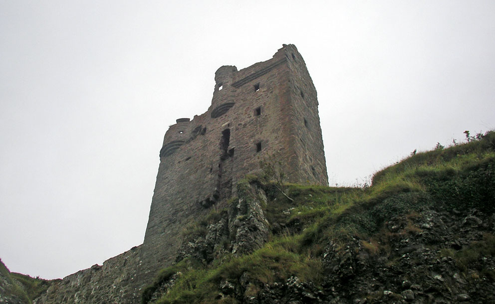
Standing tall on the north end of Kerrera is this memorial to David Hutcheson. In 1851 Hutcheson, along with his brother Alexander, and David MacBrayne, became the owners of the steam ship company that survives today as Caledonian MacBrayne. I climbed up to the monument, intent on sitting on its massive base. But the five-foot-high fence that surrounded it, tipped with needle-sharp iron spikes, looked too evil to climb. The wording on the memorial reads: ‘Erected by a grateful public in memory of David Hutcheson by whose energy and enterprise the benefits of greatly improved steam navigation were conferred on the West Highlands and Islands of Scotland’.

It's great fun to sit here and watch Hutcheson's legacy sail by, either the 'Isle of Mull' on the short crossing to Mull, or the 'Clansman' on its long trek to Barra. Thousands of people see this monument every day, but few ever see the other memorial to Hutcheson, the one that marks his grave, high up in the cemetery just north of Oban.


Monday, April 29, 2013

Afoot on Kerrera 9

On Rubh a’ Bheàrnaig, the headland that marks the northernmost tip of Kerrera, lies Cladh a’ Bheàrnaig. The name may mean the burial ground of St Marnock, and on a 1750 map it is called “Clyvernock, an old monastery”. Marnock was a bishop in the early 600s, and there is a chapel dedicated to him at Kilfinan, thirty miles south of Kerrera, where he had a retreat.

The oval enclosure is split in thirds by low walls. Inside sit the remains of several buildings, one that looks like a beehive cell. Tourists in the thousands sail by Cladh a’ Bheàrnaig every year on their way to Mull and Barra. But few ever train their binoculars on these overgrown ruins, for what grabs their attention here is a giant obelisk that stands on a knoll above the monastery. Tomorrow we’ll climb up to see it.

Cladh a’ Bheàrnaig

Sunday, April 28, 2013

Afoot on Kerrera 8

Built around 1750, this is the old jetty at Bàrr nam Boc (height of the roe-buck). After being ferried over from Mull cattle were driven from here to the north end of Kerrera, where they swam to the mainland at Ardentrive (aird na t-snàimh, the headland of swimming). Even after large ferries started transporting cattle in the nineteenth century, bypassing Kerrera, the mail continued to pass through here until 1864.

Barr nam Boc

Saturday, April 27, 2013

Afoot on Kerrera 7

At the end of chapter 22 (book 1) I mention not having seen the Children's Graves near Cnoc na Faire, the hill of watching. Just after the book was published I returned to Kerrera to find them. It took some doing, for dense bracken cloaked the terrain.

It is a circular enclosure of stone, barely visible under the bracken in the photo below. I had a hint to it's location after spotting it on Google Earth. If you enter these coordinates you will see it: 56°22'59.15"N, 5°34'50.51"W. Here's one version of the story behind the graves as recounted on the Kerrera website.

"A group of stones is found here although it is uncertain what they mark. One legend says that a family from Mull who had been forced to go to Glasgow for work had the misfortune to lose their children to typhoid or cholera. The heartbroken parents decided to bring the children back to Mull for burial. In those days the main route to Mull crossed the island to Barr nam Boc, the boat then sailed to Grass Point on Loch Don on Mull. It was autumn and the weather was particularly severe. After a week of waiting the parents carried the children to a sheltered spot as close to Mull as they could get and buried them there using the stones to mark the children's graves."

Tomorrow we'll visit Barr nam Boc.

Bracken covers the children's graves - Mull in the distance

Friday, April 26, 2013

Afoot on Kerrera 6

The folks that run the Kerrera tea garden also offer bunkhouse and yurt accommodation. The yurt looked interesting, but no one was around when I passed by, so I did not take a look inside. 

A few months later I came across a photo of its interior here. I have been inside several yurts that the State Parks in the US offer, but their interiors have nowhere near the character of the Kerrera yurt, not to mention the complete isolation.

Kerrera Yurt

Thursday, April 25, 2013

Afoot on Kerrera 5

One of the highlights of a walk on Kerrera is lunch at the tea garden, and I have had several. But once, after a long search to find the Children's Graves, I was starving and looking forward to a bowl of soup. But I had not checked on their hours, and when I reached the cafe, late in the afternoon, I was very disappointed to see the 'Closed' sign. I had to hike back to the ferry on an empty stomach.

Kerrera Tea Room

Wednesday, April 24, 2013

Afoot on Kerrera 4

This is a view of the oriel window in the north wall of Gylen Castle. Its floor could be lifted and hot oil dumped on unwelcome visitors. Inset in the window is a carving of a woman’s head; her long hair spreading down and out in both directions to become a cable moulding that runs along the bottom of the window. One braid of her hair winds around to the carving of a man in a skull-cap, who is pulling on this rope of hair (left side of photo). Her other braid winds around to the carving of what looks to be a man wearing a helmet or, as was reported by a visitor in 1800, a bagpipe player, who is also pulling on the rope of hair. It would be interesting to know the story behind this tug-of-war for the lady’s attention. Which course in life do you think she chose? Life with a musician, or life as a religious?

Oriel Window - Gylen Castle
Close up of the carvings

Tuesday, April 23, 2013

Afoot on Kerrera 3

Here are two moments in time. The first is Gylen Castle in 1993, sitting remote and lonely atop the south headland of Kerrera. With no signs of modern civilization in sight, being there was like stepping back in time.


Now let's jump ahead 17 years to 2010. The castle has been shored up, and a steel stairway installed to allow access to the first floor. All very nice, but the reader boards, while informative and excellently done, do intrude on the scene.


Monday, April 22, 2013

Afoot On Kerrera 2

Before we explore Kerrera we'll pay our respects to Samson, one of its ex-residents. For many years he was a landmark on the island, and I remember many cruises from Oban where he was there to see us safely out to the Sound of Mull, or greet us back to the calm haven of Oban Bay. Then one year, I think it was 2010, he must have been voted off the island, for I found him forlornly chained to Oban's North Pier.

It was a sad sight: Samson surrounded by ice cream munching tourists. But last year when I passed through Oban he was nowhere to be seen. Maybe his hair grew back and he had the strength to break his chains and escape. I hope he's found a good home.

Samson on Kerrera
Samson on Oban's North Pier

Sunday, April 21, 2013

Afoot on Kerrera 1

Let's spend the next few days wandering around Kerrera; a better place to wander would be hard to find. Along the way we'll see where a King of Scotland died; a castle perched high on a crag; the ruins of a monastery, a bagpiper pulling a woman's hair, an angel, the children's graves on the hill of the watcher, and something you'd never expect to find on a Scottish island....parrots.

Gylen Castle (photo from Book 1, Chapter 22)

Saturday, April 20, 2013

Sea Tragedy - Islay

As I returned to the car after my walk to the hermitage I came across this monument to a sea tragedy in 1847, when the brig Exmouth wrecked on the nearby shore. The plaque, Gaelic on one side, English on the other, reads:

This memorial is dedicated to the memory of 241 Irish emigrants who lost their lives on the 28th April 1847, when the brig 'The Exmouth of Newcastle' out of Derry and bound for Quebec Canada at the time of the great famine, was wrecked on the N/W coast of Islay. 108 bodies, mostly women and children (63 under the age of 14, and 9 infants) were recovered and are buried under the soft green turf of Traigh Bhan. May their souls rest forever in the Peace of Christ.

The beach of Traigh Bhan is just south of the hermitage I'd hiked to. I regret not knowing about the graves, as I would have walked the extra mile to pay my respects. Google Earth shows several large mounds there (55°50'36.37"N, 6°26'59.10"W). Does anyone know if these are the graves?


Friday, April 19, 2013

Kilnave Hermitage 3

We are now down in the heart of the hermitage. This cluster of stones is what's left of three beehive cells. Their remoteness from modern settlements has kept their stones from being robbed, but time has taken its toll and their roofs have long since fallen in.


The most unusual ruins here are several kidney shaped structures, some of them built onto each other to form a wall. I poked my head into one of the small entrances to see if I could get inside, but it did not look stable.


I don't think many people make the effort to visit this historic place, which is probably for the better. I spent a memorable hour of solitude here and then started back. The return to the car would be mostly downhill, except for this daunting first bit, a steep climb back to the top of the cliff.

Thursday, April 18, 2013

Kilnave Hermitage 2

After dropping down the steep ravine we come to a wall with a small entrance. It's built across the path, so perhaps this is where a gatekeeper warded off unwelcome visitors.


Guards still stand watch, but they are easily shooed away. 


Below the guard house and the watch-goats stands a cluster of beehive cells and several kidney shaped dwellings, which we'll see tomorrow.

Wednesday, April 17, 2013

Kilnave Hermitage 1

On the west coast of Islay, four miles from Kilnave, lies a complex site, part of which may have been a hermitage associated with the monastery at Kilnave. To get there leave your car near Sanaigmore and follow the coastline west. After a mile, start to work your way uphill and head over to the western cliffs. As you do, keep an eye out for this little peninsula. Click here for some aerial photos and a full description of the site.


The remains of a promontory fort lie to the north of this peninsula. But what I'd come to see, and barely visible from the cliff top, was a cluster of beehive cells and some odd, kidney shaped structures. I'd read somewhere (in a book, I've misplaced and do not remember the title of) that these little buildings may have been a place of retreat for the monks of Kilnave.

Wanting to see the ruins up close I found two narrow ravines that led down to the peninsula. The southern one was narrow, steep, and scary. But there was a rough track down the wider, northern one. Tomorrow we'll head down it for a closer look.


Tuesday, April 16, 2013

Kilnave Cross - Islay

Another Islay cross full of character is this one at Cill Naoimh (Kilnave), seven miles NW of Cill Chomian. Some sources date it to the 5th Century, others to the 8th. You can read an extensive description of this work of art that has survived the centuries, albeit a bit worn and weary, here.

Kilnave Cross
Four miles west of Kilnave, below the hill of Cnoc Uamh nam Fear, lie the ruins of a monastic settlement possibly associated with Kilnave; where the monks had their Diseart, their place of retreat. It is reached by descending a narrow ravine that slices down through the cliffs to a rocky shelf, 100 feet above the sea. We'll head there tomorrow.

Monday, April 15, 2013

Sanctuary Cross - Islay

Gnarled and worn, the sanctuary cross of Cill Chomain marked a safe haven on Islay for centuries. Something about it is captivating. It exudes a feeling of enduring strength, standing the trials of time, but slowly being worn down - as time does to us all. 

Sunday, April 14, 2013

Castle Coeffin - Lismore

This is Castle Coeffin on the west side of Lismore: the most evocative castle ruin in the isles. The spiky remnants of a 13th century hall house rise from the top, and below them bits of the bailey that once defended the entrance can be seen.


On the mainland across Loch Linnhe you can see the massive Glensanda quarry. In its grounds is Castle Mearnaig; possibly the most inaccessible castle ruin in Scotland. Which means one thing....I must find a way to see it!


When my wife and I visited Coeffin in 1993 I wandered through a derelict farm house next to the castle. Trees were growing inside, and most of its roof was gone.

Coeffin Farmhouse - 1993
The next photo was taken on a visit in 2006. It was good to see that the house had been renovated and is now lived in.

Coeffin Farmhouse - 2006

Saturday, April 13, 2013

Earth House of Spiders

Tigh nan Leacach, the house of flagstones, lies high in the hills of South Uist near Loch nan Airm (the loch of weapons). It is  a souterrain or, as labeled in early maps, an 'Erd House' (earth house).

Tigh nan Leacach
Its inner chamber is 25 feet long, and I wanted to crawl in to see it. But as I started in I came across this outer defensive shield. Could Shelob be waiting inside for supper to show up?  Not crazy about spiders in dark places I retreated. I was also a bit large to fit through the narrow opening.

Come into my parlour

Friday, April 12, 2013

Carn Cùl ri Èirinn - The Cairn with its Back to Ireland

Standing high atop a ridge on the southwest side of Iona is Carn Cùl ri Èirinn, the cairn with its back to Ireland. The wonders of nature; seabirds, waves, sparkling sands and whales; that someone experienced here long ago inspired the following.

          Delightful it would be on the breast of an island
               on a rocky clifftop,
          that I might often see
               the face of the ocean.

          I'd see her heaving waves
               on glittering surface,
          as they sang thus to their Father
               in eternal surging.

          I'd see her smooth sparkling sands
               it would be no cause for sorrow;
          I'd hear the call of wondrous seabirds,
               a cry of gladness.

          I'd hear the thunder of the breakers
               upon the rocks,
          I'd hear a clamour beside the graveyard,
               the sound of the ocean.

          I'd see her whales, the greatest
               of all wonders.
          I'd see her ebbing and flooding
               in their order;
          may my mystical name be
               'Cùl ri Èirinn'.

From 'Meallach Liom Bheith i n-Ucht Oilein, 'Delightful to be on the Breast of an Island'.
12th century (but attributed to St Columba) - see page 14 in Songbook of the Pillagers.

Carn Cùl ri Èirinn - The Cairn with its Back to Ireland

Thursday, April 11, 2013

Teed off on Iona

This photo is looking north from Dun-I, the highest point of Iona. I have visited it several times to sit atop the trig-pillar and soak in the view. But the last time was unpleasant. I had to listen to a woman having a loud conversation on her mobile phone. I thought about grabbing it and throwing it into the nearby Well of Eternal Youth, but I didn't think St Columba would have approved. After 20 minutes I lost all hope she'd shut up so I left.

Looking north from atop Dun-I
A better memory of fellow visitors to Iona was this pebble cross someone made on the grassland above the Port of the Coracle in 1988.


Wednesday, April 10, 2013

Tee-Time on Iona

The wettest I ever got was during a walk around Iona. It rained most of the day, and my boots become waterlogged after crossing a morass near Loch Staonaig. But it was still a great day. No golfers were about, so as I crossed the links I took a break at the third hole to wring out my socks.

The hillock in the distance (left) is the site of the fort of Dun Bhuirg. To the right, not shown in the picture, is Dun-I, the summit of the island and our next stop.

Tee-Time on Iona

Tuesday, April 9, 2013

The Sands Sing

Name that Tune - A short walk on Camus Sgiotaig, the Singing Sands of Eigg.

Monday, April 8, 2013

Inchkenneth 5

Before we leave Inchkenneth we'll visit this rectangular patch of rubble near Inchkenneth House. It is all that's left of the home where Neil Macgillivary and his family lived. Neil was  boatman and island manager from the late 1940s through to 1968. His story is told in Timothy Neat’s When I was Young: Voices from Lost Communities in Scotland - The Islands. A photo of Neil, taken when he was seventeen in 1932, is on the cover of an early edition of the book. He also appears in Rosalind Jones' Tea with Chrissie


I was fortunate to have met Neil the day before going to Inchkenneth, and he shared some of his stories of living on the island (see Book 1, Chapter 12). Sadly, Neil passed away in 2010, and is buried in Kilfinichen cemetery on Mull.


Sunday, April 7, 2013

Inchkenneth 4

From the chapel we head down to the Humpies, an interesting bit of lumpy terrain at the south end of the island.

The Humpies
In the Humpies you will find dozens of hidden declivities and tidepools. You will also find views out to the Treshnish Isles and Staffa.

Staffa seen from the Humpies
After exploring the Humpies we climb to the summit of the island, 160 feet above the sea. The climb wore me out, so I paused to enjoy my standard island snack - a beer and bag of crisps. I wonder if MacEwen's or Walkers would be interested in sponsoring some island trips. I have several  photos of this fellow sitting on island summits enjoying a red-tinny of Export along with a bag of smoky-bacon.

Atop Inchkenneth

Saturday, April 6, 2013

Inchkenneth 3

The Inchkenneth Cross, carved from a piece of blue slate, dates to the sixteenth century. Just visible at the bottom of the shaft is a pair of shears, and below them is something with bristles, possibly a brush or comb. The significance of the shears and comb may come from their ceremonial use in cutting the tonsure.

Inchkenneth Cross
Close-Up of the Shears and comb
Boswell went to pray at this cross in the graveyard. Once deep in prayer he heard ghostly noises and ran away. I heard no ghostly noises, just clucking chickens that wanted to eat my sandwich.

Friday, April 5, 2013

Inchkenneth 2

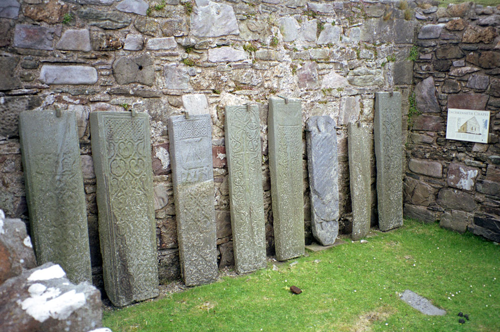
I had wanted to see Inchkenneth chapel ever since reading Boswell's account of his (and a companion's) stay on the island in 1773. A Celtic hand bell once rested on the altar, but sadly it has gone astray. Behind the chapel is the large walled garden, and hiding behind the trees is Inchkenneth House. Half of the Inchkenneth Cross can be seen at the far left. We'll get a better view of it tomorrow.


Mounted securely to the inner wall of the chapel is an amazing set of eight medieval tombstones. My favourites are the third one from the left with a Maclean Sea-Galley depicted at the top, and the next one over with the Sword-Cross.


Thursday, April 4, 2013

Inchkenneth 1

This photo from Book 1 is of Inchkenneth in Loch na Keal. The cloud-shrouded headland is Burg on the island of Mull. At its base lies the famous fossil tree. The low terrain that spans the horizon is the Ross of Mull leading out to Iona, and the bumpy terrain in the middle distance is the south tip of Inchkenneth known as The Humpies. I got lucky with this photo. I didn't notice the sea eagle soaring over Inchkenneth House until after I took the picture.


The next photo is a zoom-in on the previous one. To the far left you can see an old wall that may have been part of the monastery. To its right is the walled garden, and behind that the ruin of Inchkenneth Chapel stands in a small burial ground. Over the next few days we'll see some more of Inchkenneth. 


Wednesday, April 3, 2013

Goodbye to Eriskay - 6

Before we say goodbye to Eriskay we'll pay a visit to the island's two cemeteries. This is a photo of the north cemetery. The building behind it (lower left) is the Am Politician bar, named after the ill-fated ship filled with whisky. At top centre is St Michael's Church.

Eriskay Cemetery
Below is Father Allan Macdonald's grave in the south cemetery. There is a good book about Fr Macdonald, Amy Murray’s Father Allan’s Island, written in 1920. The island referred to in the title is Eriskay. Fr Macdonald worked throughout all the Barra Isles until 1905, when he died from influenza at the age of forty-six.

Grave of Fr Allan Macdonald
St Michael's Church
It's time to leave Eriskay. On my last visit I left by walking across the causeway. This sign got my hopes up, but I didn't see any otters.


Here's a last look back to Eriskay from near where the causeway reaches North Uist. 

We will be back.